
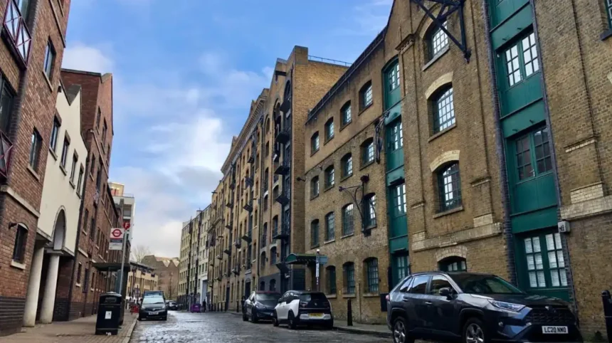
Wapping is a historic riverside neighbourhood in East London, within the London Borough of Tower Hamlets. It lies beside the River Thames, east of the Tower of London, and retains historic streets, former dock buildings and waterfront locations associated with London’s maritime economy.
- How Did Wapping Develop from a Riverside Settlement into a Maritime District?
- Why Are the London Docks Important to Wapping’s History?
- Which Historic Buildings and Streets Should Visitors Explore in Wapping?
- What Is Wapping’s Connection to Pirates and Execution Dock?
- How Did the Thames Police Shape Wapping’s Maritime Identity?
- What Can Visitors Learn About Wapping’s Maritime Architecture?
- How Did the Decline of London’s Docks Change Wapping?
- Which Riverside Walks Reveal Wapping’s Historic Connections to the Thames?
- Start at St Katharine Docks
- Continue along Wapping Wall
- Explore the historic public houses
- Continue towards Shadwell Basin and Limehouse
- How Is Wapping Connected to the Wider History of Tower Hamlets?
- How Can Visitors Explore Wapping’s Heritage Responsibly Today?
- Why Does Wapping Remain Important to London’s Historic Identity?
Wapping occupies a distinctive position in London’s geography. Its riverside location connected merchants, sailors, warehouse workers and ship operators with international trading routes. The neighbourhood developed around the movement of goods along the Thames and the industries that supported commercial shipping.
The name Wapping is commonly associated with an Anglo-Saxon settlement and the name Waeppa. Historic England’s archaeological assessment identifies Wapping as an old settlement with evidence of human activity from different periods. Its early landscape included marshland, river channels and reclaimed ground.
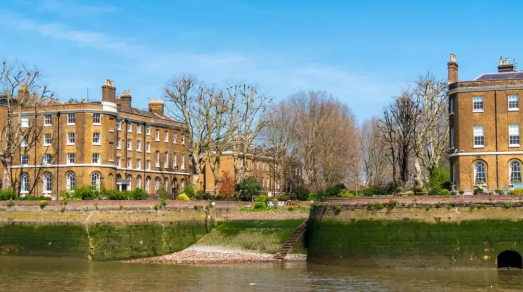
Today, Wapping combines residential streets, historic waterfront structures, modern housing and surviving industrial features. Former warehouses stand beside converted residential buildings, while public riverside routes provide views across the Thames towards Rotherhithe and other parts of South London.
The neighbourhood forms part of the wider East End, a historic area associated with London’s port economy, migration, manufacturing and working-class communities. Its location within Tower Hamlets makes it an important place for understanding how the borough developed around the river.
Visitors exploring Wapping encounter more than attractive waterfront scenery. Its streets and buildings reveal the relationship between maritime commerce, urban expansion, industrial decline and regeneration.
How Did Wapping Develop from a Riverside Settlement into a Maritime District?
Wapping developed from a riverside settlement into a maritime district as river defences, wharves, shipbuilding businesses and commercial warehouses expanded. Its position beside the Thames attracted sailors, merchants and dock workers, establishing a community closely connected with London’s international trade.
Wapping’s early development depended on managing the Thames waterfront. River defences and drainage works helped make parts of the marshy landscape suitable for settlement. Tower Hamlets’ conservation documentation records riverside embankment and wharf development from the medieval period onwards.
By the 16th century, riverside businesses served merchants transporting goods into London. Wharves provided places for vessels to unload cargo, while workshops supported the repair and equipment of ships. Sailmakers, blacksmiths, rope-makers and other trades supplied the maritime economy.
Wapping High Street became a central route through this riverside settlement. Houses, taverns and commercial premises developed close to the water because sailors and merchants needed accommodation, food, equipment and services near their workplaces.
The area’s commercial activity expanded alongside London’s growth as an international port. Ships brought commodities from Europe, Asia, Africa and the Americas. These trading connections also linked Wapping to the British Empire and the exploitation of enslaved people, particularly through commodities and commercial systems associated with colonial trade.
Visitors seeking broader historical context should explore the full historical background of Wapping and its maritime development. This contextual link connects the neighbourhood’s present-day streets with the economic and social forces that shaped its earlier development.
Wapping’s history also includes difficult living and working conditions. Crowded housing, dangerous dock work, poverty and the uneven distribution of wealth affected many riverside residents. Its historic identity therefore includes both commercial importance and the experiences of the workers who sustained London’s port.
Why Are the London Docks Important to Wapping’s History?
The London Docks transformed Wapping into a major enclosed port complex when they opened in 1805. They provided secure facilities for unloading and storing imported goods, including tobacco, wine, tea and spices, before changing shipping technology eventually made London’s inner docks less commercially competitive.
The London Docks were developed to address the limitations of London’s busy riverside wharves. Congestion, cargo theft, delays and limited warehouse capacity created pressure for more organised port facilities. Enclosed docks offered merchants greater control over goods and storage.
The London Dock Company opened the London Docks in Wapping in 1805. Their warehouses and basins handled imported commodities destined for London’s markets. Tobacco, wine, tea and spices were among the products associated with the complex.
The dock system changed the surrounding neighbourhood. Large industrial buildings replaced some smaller houses and workshops. High walls separated dock operations from surrounding streets, while entrances controlled the movement of workers, carts and merchandise.
This infrastructure connected Wapping to an extensive international supply chain. Cargo arrived by ship, entered secure storage, underwent handling or processing, and then moved onwards by road, river or other transport networks. Warehouses served as essential links between overseas suppliers and British consumers.
The docks also reflected the unequal history of global commerce. The London Museum documents how profits from Britain’s trade in enslaved Africans helped fund aspects of the London Dock Company’s development. The commodities moving through London’s port were part of wider imperial systems with profound human consequences.
The London Docks ceased operating in 1968, marking the end of a major chapter in Wapping’s commercial history. Their closure reflected broader changes in maritime transport, including containerisation, larger ships and the relocation of cargo handling to ports farther down the Thames.
Much of the original dock basin was subsequently filled or redeveloped. However, historic boundaries, sections of dock walls, surviving warehouses and the layout of the surrounding streets continue to reveal the scale of the former port.
Which Historic Buildings and Streets Should Visitors Explore in Wapping?
Wapping’s historic character survives in its riverside streets, converted warehouses, former dock entrances and traditional public houses. Key places include Wapping High Street, Wapping Pierhead, Oliver’s Wharf and the Prospect of Whitby, each illustrating a different aspect of the neighbourhood’s maritime past.
Wapping’s heritage is best understood by examining its buildings in relation to the river. The combination of narrow streets, industrial architecture and historic waterfront structures reflects the area’s development as a working port.
Wapping High Street
Wapping High Street follows the riverside settlement’s historic route. Its buildings preserve elements of the streetscape associated with sailors, dock workers, merchants and public houses. The road was laid out in the 16th century and later became a prominent part of the area’s maritime community.
Visitors should look for changes in building scale and materials. Older brick structures and converted commercial buildings indicate how residential and industrial uses have overlapped throughout Wapping’s history.
Wapping Pierhead
Wapping Pierhead contains historic houses built in 1811–13 beside the former entrance to the London Docks. These properties accommodated senior dock officials who needed to oversee activity at the port entrance. Their position demonstrates how closely residential architecture and port administration were connected.
The surviving buildings also provide evidence of the original dock layout. Although the historic basin has disappeared, the architecture helps visitors interpret the former relationship between the river, dock entrances and nearby streets.
Oliver’s Wharf
Oliver’s Wharf is a former riverside warehouse built in 1869–70. Historic England records its association with the tea trade and identifies its Gothic architectural style. The building illustrates the substantial warehouse construction that became characteristic of the Victorian Thames waterfront.
Its industrial origins are important to the area’s present appearance. Warehouse conversion has preserved elements of the historic building stock while introducing new residential uses.
The Prospect of Whitby
The Prospect of Whitby is a well-known historic riverside public house on Wapping Wall. Its location reflects the long association between riverside taverns and maritime communities. Public houses provided places for sailors, dock workers and local residents to eat, drink and meet.
Visitors can combine the pub with a walk along the Thames. Its waterfront setting provides a direct view of the river that shaped the neighbourhood’s employment, architecture and daily life.
What Is Wapping’s Connection to Pirates and Execution Dock?
Execution Dock is associated with historic public executions of people convicted of maritime crimes, including piracy. The site forms part of Wapping’s darker maritime heritage, reflecting the dangers of seafaring, the enforcement of maritime law and the historic importance of controlling trade on the Thames.
The traditional location of Execution Dock is associated with Wapping’s riverside, near the area of the present-day Overground station. For centuries, the Thames was a major commercial route, and piracy, smuggling and theft threatened the movement of valuable cargo.
Executions at Execution Dock served as public demonstrations of authority over maritime crime. Convicted pirates were subjected to punishments intended to deter others from attacking merchant vessels or disrupting shipping.
One of the most famous figures associated with the site is William Kidd, commonly known as Captain Kidd. He was executed in 1701 after being convicted of piracy. Historical accounts associate the display of executed pirates’ bodies with the tidal river, reinforcing the punishment’s public character.
The history requires careful interpretation. Piracy, privateering and maritime warfare were not always clearly separated in the political and commercial world of the 17th century. Privateers operated under government authorisation during conflicts, while pirates attacked ships without lawful permission. The distinction depended on legal status and the circumstances of particular voyages.
Modern visitors will not find a preserved execution facility comparable to a museum building. The importance of Execution Dock is primarily historical and geographical. The site is part of the riverside landscape associated with the legal systems that protected trade and punished maritime offences.
Exploring this history also reveals the contrast between Wapping’s reputation for crime and its everyday role as a residential and working district. The area’s past included sailors’ accommodation, commercial workshops, family homes and religious institutions, not only notorious criminal events.
How Did the Thames Police Shape Wapping’s Maritime Identity?
Wapping has a significant connection to the development of river policing in London. The Thames River Police was established in 1798 to protect valuable cargo and reduce theft from ships, helping create a more organised system of law enforcement along one of Britain’s busiest commercial waterways.
The Thames River Police emerged when cargo theft threatened the profitability of London’s port. Ships carried valuable goods, and the busy waterfront created opportunities for theft during loading, unloading and storage.
The force was initially established to protect cargo associated with the West India trade. Its work subsequently expanded across the Thames, and it became an important predecessor of modern river policing. The Ragged School Museum’s local history account records that the organisation was established in 1798 and assumed wider responsibilities in 1800.
Wapping’s location made it suitable for a police presence close to the working river. The neighbourhood contained dock entrances, warehouses, wharves and vessels carrying valuable merchandise. Effective policing helped protect commercial property and maintain order in this crowded environment.
The history also illustrates the relationship between trade and public institutions. As London’s port expanded, authorities needed systems to regulate cargo movement, investigate theft and protect people working on the river.
Visitors interested in this connection should pay attention to the relationship between Wapping High Street and the Thames waterfront. The area’s historic streets reveal how commercial activity, residential life and public services developed together.
The Thames River Police story also places Wapping within a broader history of London’s institutions. The neighbourhood was not simply a place where goods passed through. It contributed to the development of systems designed to manage the risks and responsibilities associated with international trade.
What Can Visitors Learn About Wapping’s Maritime Architecture?
Wapping’s maritime architecture includes brick warehouses, dock walls, former wharves, historic houses and buildings adapted for modern residential use. These structures reveal how merchants stored cargo, dock authorities managed shipping and developers reused industrial sites after commercial port activity declined.
Architecture is one of the clearest ways to understand Wapping’s development. The neighbourhood contains buildings from different periods, each reflecting changes in commerce, engineering and land use.
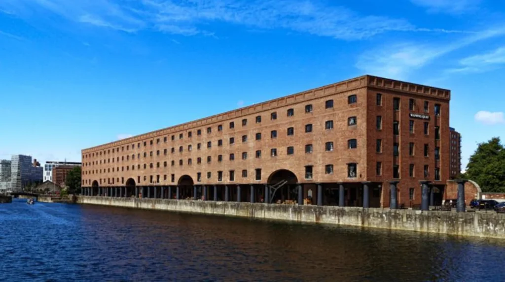
Brick warehouses were designed for storing imported goods. Their substantial walls and repetitive openings reflect the demands of commercial storage. Some surviving buildings now contain flats or other modern uses, although their industrial proportions remain visible.
Dock walls and entrances helped separate secure port facilities from public streets. These boundaries controlled access and supported the operation of enclosed docks. Sections of historic dock walls survive around redeveloped sites, providing physical evidence of the former port.
Georgian and Victorian buildings reflect the expansion of the district during periods of commercial growth. Residential terraces accommodated local households, while larger waterfront structures served dock officials, merchants and warehouse operators.
Converted warehouses demonstrate how industrial heritage has been incorporated into contemporary housing. Their reuse preserves parts of Wapping’s historic built environment while changing how the buildings function.
Tower Hamlets’ conservation assessments identify Wapping Wall and Wapping Pierhead as areas where surviving architecture and the historic street pattern contribute to the neighbourhood’s character.
Visitors should examine architectural details rather than looking only at building facades. Changes in window size, loading openings, brickwork and building height help distinguish former commercial structures from ordinary houses.
The relationship between buildings and streets is equally important. Narrow lanes and former access routes connect the modern neighbourhood to the historic movement of workers and goods between warehouses, wharves and the river.
How Did the Decline of London’s Docks Change Wapping?
Wapping changed substantially when commercial shipping declined in London’s inner docks during the second half of the 20th century. Dock closures removed traditional employment, left large industrial sites underused and created opportunities for redevelopment, warehouse conversion and new residential neighbourhoods.
The decline of London’s docks resulted from changes in global shipping. Containerisation standardised cargo handling, while larger vessels required facilities that many older enclosed docks could not efficiently accommodate. Commercial shipping increasingly moved towards ports farther downriver.
The London Docks closed in 1968, and the wider transition away from London’s traditional dock industry reshaped employment across the Docklands area.
For Wapping, the consequences extended beyond the disappearance of ships and cargo. Dock-related jobs supported transport workers, warehouse employees, repair businesses, suppliers, shops and public houses. When the docks closed, these connected economic activities also faced disruption.
Former warehouses became vacant or lost their original commercial purpose. Some buildings were demolished, while others survived because their structure and location suited alternative uses. The resulting landscape combined historic remnants, underused industrial land and changing residential patterns.
The London Docklands Development Corporation, established in 1981, formed part of the wider regeneration process. Development across Docklands brought new housing and commercial uses to areas affected by industrial decline.
In Wapping, former warehouse buildings became residential properties, and old dockland sites were adapted for new urban uses. The transformation preserved some of the physical evidence of maritime commerce while changing the neighbourhood’s population and economy.
Regeneration also created challenges. New development changed the relationship between local communities and the historic waterfront. Preserving dock walls, streets and warehouses became important for maintaining the area’s identity as residential and commercial uses evolved.
Wapping therefore represents a broader pattern in East London: the transition from a manufacturing and port economy to a mixed urban environment where heritage, housing, leisure and modern employment occupy the same landscape.
Which Riverside Walks Reveal Wapping’s Historic Connections to the Thames?
Wapping’s riverside walks connect historic streets, former warehouses, dock entrances and traditional pubs along the north bank of the Thames. Walking east from St Katharine Docks towards Limehouse allows visitors to examine how the waterfront developed and how its industrial character survives today.
The Thames Path is a long-distance walking route following the River Thames. Its urban sections provide access to historic waterfronts, bridges, residential districts and former commercial areas. In Wapping, the route offers an opportunity to connect individual buildings with the wider geography of London’s port.
A useful walking itinerary begins near St Katharine Docks, close to Tower Bridge, and continues eastwards along accessible riverside routes towards Wapping and Limehouse. Tower Hamlets’ published walking guidance identifies Wapping as a distinctive section of the borough’s riverside heritage.
Start at St Katharine Docks
St Katharine Docks opened in 1828 as a commercial dock complex designed by engineer Thomas Telford. Construction required the demolition of numerous houses and the medieval hospital of St Katharine. The docks later declined as a commercial port and were transformed into a marina.
The surviving basins and surrounding buildings introduce visitors to the engineering scale of London’s historic dock system.
Continue along Wapping Wall
Wapping Wall follows the riverside embankment. Its historic development reflects efforts to control flooding and establish a continuous working waterfront. The road and nearby buildings provide a strong sense of the relationship between river defences and port infrastructure.
Look for former warehouses, older brick walls and narrow routes connecting the street with riverside properties.
Explore the historic public houses
The Prospect of Whitby and the Town of Ramsgate are associated with Wapping’s maritime past. Their locations connect the neighbourhood’s social history with the working waterfront. Visitors can examine the surrounding streets and river views while learning how public houses served sailors and local residents.
Continue towards Shadwell Basin and Limehouse
Shadwell Basin preserves an open stretch of water from the former dock system. Its surviving entrance infrastructure provides evidence of how vessels entered and moved through the enclosed port. Further east, Limehouse Basin links historic waterways with the modern residential environment.
The full route length depends on the selected riverside paths, access points and starting location. Visitors should check current access conditions before setting out, as some waterfront sections pass through areas with restricted or changing access.
A riverside walk offers more than views. It helps explain how the river shaped the placement of buildings, the movement of workers and the growth of East London’s maritime economy.
How Is Wapping Connected to the Wider History of Tower Hamlets?
Wapping forms part of Tower Hamlets’ wider history of riverside trade, migration, industrial employment and urban regeneration. Its development connects the borough’s historic port communities with neighbouring districts, including Shadwell, Limehouse, Whitechapel and the Isle of Dogs.
Tower Hamlets developed around several interconnected communities rather than a single historic centre. The River Thames provided transport and commercial opportunities, while docks and manufacturing businesses generated employment across the East End.
Wapping’s role was closely linked to neighbouring districts. Shadwell developed around maritime employment and dock infrastructure, Limehouse became associated with shipping and riverside industries, and the Isle of Dogs grew around major enclosed docks.
These districts formed parts of a wider economic network. Goods entering the port passed through warehouses, merchants’ premises and transport routes serving London’s markets. Workers travelled between residential streets and employment sites throughout the Docklands area.
The borough’s history also reflects migration. Maritime commerce brought sailors, merchants and workers from different parts of Britain and overseas. Successive communities contributed to local businesses, religious institutions, food cultures and neighbourhood identities.
The legacy of empire remains an important part of this history. London’s wealth was connected to colonial commerce, including commodities produced through enslaved labour. Understanding Wapping requires recognising these economic relationships alongside its architecture and commercial achievements.
The present-day borough combines historic neighbourhoods with modern residential developments and major employment centres. Wapping’s historic warehouses and dock walls provide a local perspective on changes that affected East London more broadly.
Visitors interested in this wider context can explore the London Museum Docklands. Located in a surviving historic warehouse at West India Quay, the museum presents the history of London’s port, global trade, migration, slavery and the transformation of Docklands. Its galleries offer historical context for understanding Wapping and the neighbouring districts.
Explore More Area Guide
Poplar East London: A Tourist Guide to Historic Landmarks
Exploring Limehouse: Historic Streets and Riverside Attractions in Tower Hamlets
How Can Visitors Explore Wapping’s Heritage Responsibly Today?
Visitors can explore Wapping’s heritage by walking public riverside routes, observing historic architecture, visiting accessible heritage attractions and learning about the communities that shaped the district. Respecting residential areas, checking access restrictions and acknowledging difficult histories help preserve the neighbourhood’s character.
Wapping is a living residential neighbourhood rather than an open-air museum. Its historic streets contain private homes, modern apartment buildings, businesses and public spaces. Responsible exploration allows visitors to appreciate its heritage without disrupting local life.
Several practical approaches help make a visit more informative.
- Walk rather than rush between attractions. Allow time to examine warehouse facades, historic street patterns and former dock boundaries.
- Use public routes. Follow signed walking paths and check whether riverside passages are open. Do not enter private courtyards, residential buildings or restricted dockland sites.
- Read historic interpretation. Council conservation documents and museum resources explain the purpose of buildings that now have different uses.
- Recognise the full history. Include the experiences of dock workers, migrants and enslaved people in the wider story of London’s maritime wealth.
- Support local businesses. Cafés, shops and public houses help maintain the area’s contemporary community and visitor economy.
Photography is useful for recording architectural details, but visitors should respect residents’ privacy. Historic buildings are often occupied, and their present use deserves consideration.
The best time to explore depends on the visitor’s priorities. Daylight is useful for examining architectural details and walking along the river. A clear view of the Thames helps reveal the relationship between the waterfront and the historic street network. Visitors should check opening times separately for museums, public houses and other attractions.
Wapping also suits visitors combining heritage exploration with a broader East London itinerary. Its location allows connections with Tower Bridge, St Katharine Docks, Shadwell and Limehouse, depending on the chosen route and available time.
Why Does Wapping Remain Important to London’s Historic Identity?
Wapping remains important because its streets, warehouses, dock walls and riverside buildings preserve evidence of London’s maritime economy. Its transformation from a working port to a residential district demonstrates how industrial heritage continues to influence urban identity, conservation and public access.
Wapping’s significance rests on the relationship between its physical landscape and London’s wider history. The river explains the original settlement’s location, while the docks explain the scale of its industrial expansion. Historic warehouses and surviving street patterns reveal how commerce shaped the built environment.
The closure of the docks changed the neighbourhood’s economic purpose, but it did not remove every trace of its maritime past. Adapted buildings and retained industrial features continue to connect modern residents with earlier generations of workers and merchants.
Heritage conservation gives these structures continuing value. Historic buildings provide evidence of past construction methods, commercial practices and patterns of urban development. Their reuse also demonstrates how older structures can accommodate contemporary needs without erasing every feature of their original purpose.
Wapping’s story has broader implications for East London. Other former industrial areas face similar questions about preserving historic character while providing housing, public amenities and employment. The neighbourhood illustrates why regeneration involves more than replacing old buildings with new ones: it also involves understanding the significance of existing streets, waterfronts and community histories.
For tourists, Wapping offers a way to examine these changes directly. Its riverside walks reveal the geography of the former port, its historic buildings illustrate the commercial architecture of earlier centuries, and its surviving public houses connect the waterfront to everyday social life.
The area’s history also encourages a balanced understanding of London’s prosperity. Maritime trade supported employment and commercial growth, but it was also connected to imperial power, unequal working conditions and the exploitation of enslaved people. Including these realities creates a more complete account of the neighbourhood.
Exploring Wapping ultimately means examining the relationship between place, commerce and community. Within Tower Hamlets, it remains a distinctive example of how East London’s historic waterfront continues to shape the modern city.
Where is Wapping in London?
Wapping is a historic riverside neighbourhood in the London Borough of Tower Hamlets, East London. It lies on the north bank of the River Thames, east of the Tower of London.