Tower Hamlets offers visitors a direct view of East London’s changing urban landscape, from historic docklands and traditional market streets to modern skyscrapers, regenerated waterfronts and community green spaces. Located in the East End of London, the borough combines centuries of maritime history with contemporary architecture, international business and diverse neighbourhood life.
- What Makes Tower Hamlets an Important Place to Experience East London’s Changing Landscape?
- How Did Tower Hamlets Develop from Historic Docklands into Modern East London?
- Which Parts of Canary Wharf Best Show East London’s Modern Transformation?
- How Can Visitors Explore the Historic Docklands and Their Regeneration?
- Where Can Visitors Experience Traditional Markets Alongside Modern Development?
- How Do Whitechapel and Brick Lane Reflect Tower Hamlets’ Cultural Identity?
- Which Parks and Green Spaces Reveal Another Side of Tower Hamlets?
- How Is Regeneration Changing Housing, Streets and Public Spaces in Tower Hamlets?
- Which areas are experiencing significant change?
- What should visitors look for when observing regeneration?
- How Can Visitors Travel Around Tower Hamlets to Compare Its Changing Neighbourhoods?
- How Can Digital Nomads and Business Travellers Experience Tower Hamlets Beyond Its Offices?
- How Will Future Development Influence Tower Hamlets’ Urban Landscape?
- How Can Visitors Plan a Complete Tower Hamlets Changing-Landscape Walk?
- Why Is Tower Hamlets Worth Exploring for an Understanding of East London’s Future?
The London Borough of Tower Hamlets includes Canary Wharf, the Isle of Dogs, Whitechapel, Poplar, Limehouse, Bethnal Green, Bow and parts of the wider Docklands area. Each neighbourhood reveals a different stage of London’s urban development. Former industrial sites now accommodate offices, homes, restaurants and public spaces, while historic streets and markets continue to serve established communities.
Tower Hamlets Council identifies eight regeneration areas, including Canary Wharf, South Poplar and the Isle of Dogs, Whitechapel, Brick Lane and Banglatown, Shoreditch and Aldgate, Hackney Wick and Fish Island, Leaside, and Central Tower Hamlets. These areas demonstrate how planning, housing, transport, commerce and public space shape the borough’s future.
For travellers, the best way to understand this transformation is to explore the borough on foot, use its public transport connections and compare historic landmarks with contemporary developments.
What Makes Tower Hamlets an Important Place to Experience East London’s Changing Landscape?
Tower Hamlets illustrates East London’s transformation through historic docklands, financial districts, traditional markets, residential regeneration and public green spaces. Its combination of industrial heritage and contemporary development allows visitors to examine how economic change, transport investment and community life reshape an urban environment.
The borough occupies a strategic position along the River Thames, east of the City of London. Its geography connects historic trading districts with modern commercial centres and residential neighbourhoods. The Thames, former docks, canals and railway infrastructure continue to influence how people move through the area.
The transformation is particularly visible around Canary Wharf, where former dockland infrastructure sits alongside tall office buildings, landscaped squares, shopping facilities and waterfront walkways. In Whitechapel and Poplar, established high streets and residential communities exist alongside redevelopment projects.
Tower Hamlets is also one of London’s most culturally diverse boroughs. Its neighbourhoods reflect successive waves of migration, industrial employment and commercial growth. Bangladeshi heritage is especially prominent around Whitechapel and Brick Lane, while the Docklands retains physical evidence of the shipping industries that shaped East London’s economy.
The borough’s changing landscape is therefore not limited to architecture. It includes changes in employment, housing, transport accessibility, public amenities and the relationship between new developments and existing communities.
Visitors gain a fuller understanding by examining both the physical environment and the social history behind it.
How Did Tower Hamlets Develop from Historic Docklands into Modern East London?
Tower Hamlets developed through maritime trade, industrial employment, population growth and successive waves of urban redevelopment. The expansion and later decline of the docks reshaped local employment, while regeneration from the late twentieth century transformed former industrial land into commercial districts, homes and public spaces.
The area’s history extends well beyond the modern office towers of Canary Wharf. The River Thames supported trade, transport and shipbuilding, while docks and warehouses created employment for generations of East London residents.
The West India Docks opened in 1802 and became an important part of London’s maritime infrastructure. The East India Docks followed in 1806, supporting trade connected with Britain’s commercial networks in Asia. Warehouses, shipyards, workers’ housing and transport links developed around these facilities.
During the nineteenth century, industrial expansion increased the population and intensified pressure on housing and public health. The need for accessible outdoor space became increasingly important. Victoria Park opened in 1845 and remains a major example of public investment in East London’s urban environment.
The twentieth century brought further change. Containerisation altered shipping requirements, and the traditional London docks declined before their closure. The formation of the London Docklands Development Corporation in 1981 marked a major stage in the redevelopment of former dockland areas.
Canary Wharf subsequently emerged as a major financial and commercial district. The Docklands Light Railway, which opened in 1987, improved transport connections and supported the area’s transformation. More recent development has expanded residential accommodation, retail facilities, hospitality venues and public spaces.
To explore the earlier industrial and social context, read the full [Tower Hamlets history and heritage guide] to understand how dockside communities, migration and industrial expansion shaped the neighbourhoods visitors see today.
The historic landscape remains visible in dock basins, warehouse buildings, traditional street layouts, surviving industrial structures and established residential areas. These features help explain why modern Tower Hamlets differs from a newly built business district without an industrial past.
Which Parts of Canary Wharf Best Show East London’s Modern Transformation?
Canary Wharf demonstrates East London’s shift from dockland industry towards international finance, residential development and leisure. Visitors can examine contemporary architecture, landscaped waterfronts, public squares and transport infrastructure while observing how new buildings integrate with historic docks and established neighbourhoods.
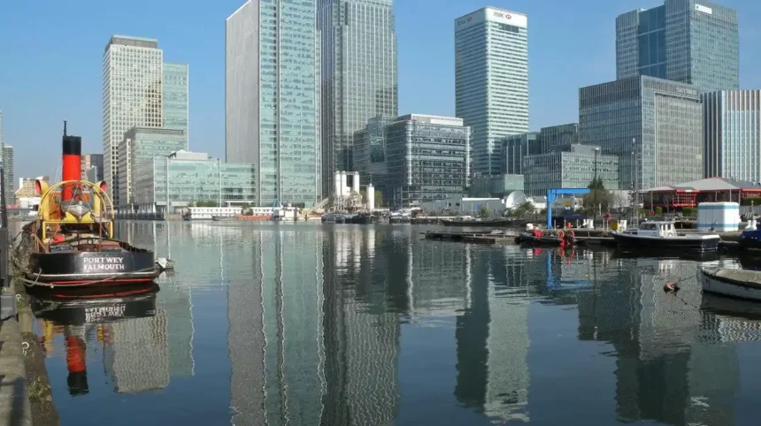
Canary Wharf is one of the most recognisable examples of regeneration in Tower Hamlets. Its towers accommodate businesses across finance and other professional sectors, while the surrounding district includes shops, restaurants, hotels, residential buildings and pedestrian routes.
The former dockland setting remains an essential part of the experience. North Dock and South Dock provide open-water spaces between modern buildings, connecting the district’s maritime geography with its current commercial identity.
What can visitors see around Canary Wharf?
- Canada Square: An open public square surrounded by high-rise office buildings. The space hosts events and provides a ground-level perspective on the financial district.
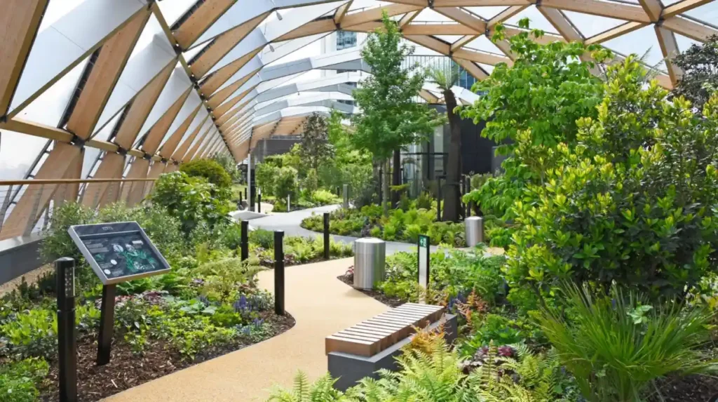
- Crossrail Place Roof Garden: A landscaped rooftop garden above the Elizabeth line station, featuring planted pathways and trees within a distinctive roof structure.
- Jubilee Park: A green space with lawns, water features and planted areas between major commercial buildings.
- South Dock and North Dock: Waterfront areas where visitors can observe the relationship between historic dock basins, modern construction and pedestrian routes.
These spaces demonstrate how public realm design contributes to the experience of a high-density commercial district. Public realm refers to outdoor areas accessible to the public, including streets, squares, parks and walkways.
Crossrail Place Roof Garden also illustrates how developers incorporate public spaces into large transport and commercial projects. Visitors can move between retail areas, landscaped spaces and transport facilities without leaving the central district.
Canary Wharf is particularly useful for photography because different viewpoints reveal contrasting architectural scales. A view from the water emphasises the skyline, while walking among the towers highlights building entrances, public art, landscaping and street-level activity.
How Can Visitors Explore the Historic Docklands and Their Regeneration?
The historic Docklands reveal how shipping, warehousing and industrial employment shaped East London before redevelopment changed the area’s economy. Former docks, surviving warehouses, waterfront paths and museum collections help visitors connect contemporary buildings with the maritime industries that preceded them.
The Docklands area includes former commercial waterways and industrial sites around Limehouse, Poplar, the Isle of Dogs and Canary Wharf. Its redevelopment followed the decline of traditional cargo handling and the closure of the historic docks.
The most useful way to explore this history is to combine waterfront walks with visits to surviving buildings and heritage institutions.
Which landmarks explain the Docklands transformation?
West India Quay retains historic warehouse buildings associated with the former West India Docks. Their brick façades and waterfront setting contrast with the surrounding modern development.
Limehouse Basin connects the area’s industrial waterways with a contemporary residential and leisure environment. The basin demonstrates how former transport infrastructure now forms part of a different urban landscape.
The Isle of Dogs waterfront provides views of residential developments, dock basins, pedestrian bridges and Canary Wharf’s commercial skyline. Walking between these settings reveals how redevelopment has introduced new uses to land once associated primarily with shipping and storage.
The London Museum Docklands, housed in a historic warehouse at West India Quay, interprets London’s relationship with the river, trade and dockside communities. It is a useful starting point for understanding the economic forces behind the changing landscape. Check the museum’s official visitor information before travelling, as exhibitions, opening arrangements and access details change.
Visitors should also distinguish between physical regeneration and historical preservation. Regeneration introduces new buildings, infrastructure or uses, while preservation protects features that communicate a place’s historical significance. Tower Hamlets contains examples of both approaches.
Where Can Visitors Experience Traditional Markets Alongside Modern Development?
Tower Hamlets’ street markets preserve everyday commercial activity within a rapidly changing urban environment. Brick Lane, Whitechapel Market, Petticoat Lane and Columbia Road Flower Market provide contrasting examples of food retail, clothing, flowers and independent trading within established East London neighbourhoods.
Markets are central to understanding how Tower Hamlets functions beyond its financial district. They connect residents, independent traders, visitors and local businesses through established streets and public spaces.
The borough’s markets reflect different trading traditions and community histories. Their continued presence also shows that urban change does not involve replacing every traditional activity with offices or new residential buildings.
Which markets are worth including in a visit?
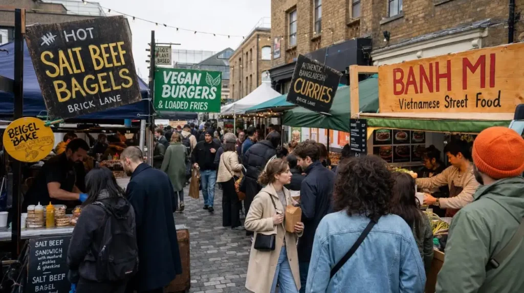
Brick Lane Market is associated with vintage clothing, street food, art and independent retail. The street also reflects the area’s history of French Huguenot, Jewish and Bangladeshi settlement. Its commercial character connects migration, entrepreneurship and changing consumer habits.
Whitechapel Market runs along Whitechapel Road. Its stalls sell fresh produce, spices, clothing, cultural goods and jewellery. The market provides a view of an established high street serving local residents as well as visitors.
Petticoat Lane Market, centred around Middlesex Street and nearby streets, is known for clothing, fashion and other goods. Its commercial environment illustrates the long-standing importance of street trading in East London.
Columbia Road Flower Market offers a different experience through flowers, plants, independent shops and nearby cafés. It is particularly suitable for visitors exploring the relationship between small businesses and a neighbourhood’s public spaces.
Tower Hamlets Council lists Brick Lane Market on Sundays, Columbia Road Flower Market on Sundays and Whitechapel Market from Monday to Saturday. Visitors should verify current hours before setting out, particularly on public holidays or during special events.
How do markets help explain neighbourhood change?
Markets provide evidence of how local economies adapt. Independent traders operate alongside established retailers, restaurants, new housing and commercial developments. The result is a street environment shaped by both long-standing community needs and changing visitor demand.
For travellers, walking between Whitechapel and Brick Lane reveals changes in shopfronts, building uses, food businesses and street activity. This experience offers a useful contrast with the more formally planned commercial spaces around Canary Wharf.
Market visits are most productive when travellers leave time to explore adjacent streets rather than concentrating solely on the stalls. Local cafés, historic buildings and everyday shopping areas provide additional context for understanding the neighbourhood.
How Do Whitechapel and Brick Lane Reflect Tower Hamlets’ Cultural Identity?
Whitechapel and Brick Lane demonstrate how migration, religious institutions, food businesses, independent retail and community organisations shape East London’s cultural landscape. Their streets combine historic buildings with contemporary businesses, showing how established neighbourhood identities continue alongside regeneration and changing commercial activity.
Whitechapel and Brick Lane are closely connected but offer different ways to experience Tower Hamlets. Whitechapel Road is a major commercial thoroughfare with markets, transport links and public institutions. Brick Lane is known for food, independent shops, street art and its association with Bangladeshi heritage.
These neighbourhoods also illustrate the relationship between urban change and cultural continuity. New restaurants and shops enter the local economy, while established businesses and community institutions maintain links with earlier generations.
What should visitors look for in Whitechapel?
Whitechapel’s streets combine traditional retail with major redevelopment. The area around Whitechapel station is particularly useful for observing the impact of improved transport connections on a busy urban centre.
The Elizabeth line has strengthened connections between Whitechapel, central London and destinations farther east and west. The District and Hammersmith & City lines, together with London Overground services, also support movement through the area.
Visitors can examine the relationship between transport infrastructure, the local market, housing and civic buildings. These elements show how a neighbourhood functions as a place to live and work rather than solely as a destination for sightseeing.
What makes Brick Lane distinctive?
Brick Lane’s identity reflects successive communities and commercial changes. French Huguenot settlement, Jewish migration and the growth of the Bangladeshi community contributed to the area’s religious, culinary and commercial character.
Restaurants, food shops and independent retailers continue to make this heritage visible. Visitors can explore the surrounding streets to see how older buildings accommodate contemporary businesses.
Street art and changing shopfronts also illustrate how cultural expression contributes to the appearance of an urban neighbourhood. These features are part of an evolving environment rather than a static historical display.
For a more complete visit, travellers should approach the area as a living community. Respectful photography, consideration for residents and support for local businesses help ensure that exploring the neighbourhood does not reduce its cultural identity to a tourist attraction.
Which Parks and Green Spaces Reveal Another Side of Tower Hamlets?
Tower Hamlets combines historic public parks, landscaped commercial gardens, community green spaces and former industrial land converted for recreation. Victoria Park, Mudchute Park and Farm, Island Gardens and Crossrail Place Roof Garden show how outdoor spaces support biodiversity, recreation and neighbourhood identity.
Green spaces provide a different perspective on East London’s development. They show how planners, residents and organisations have responded to population growth, industrial decline and the need for accessible outdoor recreation.
Which green spaces should visitors explore?
Victoria Park opened in 1845 following public campaigns for recreational space in the East End. Its landscape includes open lawns, lakes, mature trees and historic features. The park’s creation demonstrates how public green space became part of the response to nineteenth-century urban overcrowding.
Mudchute Park and Farm occupies 32 acres on the Isle of Dogs. It developed from land formed by material excavated during dock dredging. Local campaigning helped protect the site from proposed high-rise development, and the Mudchute Association was established in 1977. Today, the site combines a working farm, open countryside and community activities.
Island Gardens provides riverside lawns and views across the Thames towards Greenwich. Its landscape offers a useful contrast with the dense commercial development around Canary Wharf. The park also reflects earlier efforts to preserve the river view as industrial activity expanded around the Isle of Dogs.
Crossrail Place Roof Garden introduces planted space into a major transport and commercial development. Its design demonstrates how greenery can be incorporated into dense urban settings rather than being restricted to large traditional parks.
These locations reveal different approaches to urban planning. Some protect historic landscapes, others preserve community-led spaces, and others integrate planting into new development.
For visitors, combining a commercial district with a park creates a more complete understanding of Tower Hamlets. The comparison shows how green space affects the appearance, accessibility and everyday use of the borough.
How Is Regeneration Changing Housing, Streets and Public Spaces in Tower Hamlets?
Regeneration in Tower Hamlets combines housing development, transport improvements, commercial investment, public-space design and support for local economies. Its outcomes depend on how new infrastructure connects neighbourhoods, how affordable housing is delivered and how existing communities participate in decisions affecting their surroundings.
Regeneration is the coordinated redevelopment or improvement of an area to address physical, economic, social or environmental needs. In Tower Hamlets, it includes large commercial projects and smaller neighbourhood improvements.
The council identifies housing, employment, high streets, infrastructure and greener neighbourhoods among its regeneration priorities. It also emphasises partnership working with transport authorities, housing associations, developers and community organisations.
Which areas are experiencing significant change?
South Poplar and the Isle of Dogs form an important development area around Canary Wharf, Blackwall and surrounding residential neighbourhoods. Planning priorities include additional homes, employment opportunities, improved connections and better integration between existing communities and new developments.
Whitechapel combines market activity, established residential streets, civic facilities and improved transport connections. The Elizabeth line has strengthened its position within London’s transport network.
Central Tower Hamlets, including established neighbourhoods with local shopping streets and residential areas, illustrates the importance of improving existing places rather than concentrating all investment in major commercial centres.
Leaside, around the Lea River corridor and surrounding development areas, forms part of the borough’s broader approach to coordinating land use, infrastructure and urban growth.
These areas differ in their existing buildings, community needs and development pressures. Their regeneration cannot be understood solely by counting new towers or construction sites.
What should visitors look for when observing regeneration?
Look at how new buildings connect with the surrounding streets. Ground-floor shops, pedestrian crossings, public seating, planting and accessible entrances indicate how development meets everyday needs.
Examine the transition between older residential streets and new apartment buildings. Differences in building height, materials, street layouts and public access show how redevelopment changes the physical environment.
Transport infrastructure is equally important. Bridges, railway stations, walking routes and cycle connections influence whether residents can reach workplaces, shops, parks and public services conveniently.
Housing also forms a central part of the regeneration debate. Tower Hamlets approved its Housing Strategy for 2026–2036 in February 2026, addressing housing supply, quality, safety and affordability. Its priorities reflect the continuing pressure on local housing.
Visitors should distinguish between completed improvements, construction currently under way and projects still at the planning stage. A proposed bridge or housing scheme is not equivalent to an operational facility.
How Can Visitors Travel Around Tower Hamlets to Compare Its Changing Neighbourhoods?
Tower Hamlets is accessible by Underground, Docklands Light Railway, Elizabeth line, London Overground, bus, river services and walking routes. Using public transport between Canary Wharf, Whitechapel, Limehouse and the Isle of Dogs helps visitors compare different neighbourhoods without relying on a car.
The borough’s transport network is part of its changing landscape. Rail infrastructure has supported commercial growth, improved connections and increased access to employment and leisure destinations.
The Docklands Light Railway, known as the DLR, serves Canary Wharf, Poplar, Limehouse, the Isle of Dogs and other East London destinations. Its elevated sections offer views of waterways, housing estates, construction sites and office buildings.
The Elizabeth line provides connections through Whitechapel and Canary Wharf, linking these areas with central London and destinations beyond the capital. Underground services and London Overground routes provide further access to local neighbourhoods.
Which routes make a useful sightseeing itinerary?
A practical itinerary begins at Whitechapel, where visitors can explore the market and established commercial streets before travelling towards Limehouse or Canary Wharf.
Continue to West India Quay to examine historic warehouse buildings and former dock infrastructure. From there, walk around the waterfront and explore the modern commercial district.
Finish at Canary Wharf, where the skyscrapers, public squares, planted gardens and dock basins illustrate a different stage of urban development. Visitors with additional time can travel to Mudchute or Island Gardens to explore the Isle of Dogs beyond the financial centre.
This sequence works because it moves from established neighbourhoods to historic industrial infrastructure and then to contemporary development.
Check current Transport for London journey information before travelling. Construction work, service disruption, station accessibility and event-related changes affect individual journeys.
What should pedestrians consider?
Use signed public routes and designated crossings, particularly around major roads, bridges and construction areas. Dockside paths and pedestrian connections vary in layout and access.
Some developments contain privately managed spaces that are open to the public under specific conditions. Visitors should follow posted rules and check access restrictions where necessary.
Walking also provides opportunities to notice small-scale changes that are less visible from a train, including traditional shopfronts, historic buildings, street markets and community facilities.
How Can Digital Nomads and Business Travellers Experience Tower Hamlets Beyond Its Offices?
Tower Hamlets offers business travellers and remote workers access to commercial districts, cafés, public spaces, cultural attractions and transport connections. Canary Wharf provides a concentration of workplaces and amenities, while Whitechapel and Brick Lane offer alternative settings for breaks and neighbourhood exploration.
Canary Wharf is a practical base for business visitors because its commercial buildings sit close to shops, restaurants, hotels and public transport. Travellers with free time between meetings can explore the docks, landscaped squares and public art.
Crossrail Place and the surrounding shopping areas provide places to take breaks. However, not every public space is suitable for working on a laptop, and seating availability varies.
For remote working, cafés and dedicated workspaces offer different facilities. Visitors should check Wi-Fi availability, opening hours, noise levels, power sockets and purchase requirements before choosing a venue.
Whitechapel and Brick Lane provide a different atmosphere, with independent food businesses, markets and streets that are less dominated by high-rise office buildings. These areas are useful for a lunch break or an evening walk.
The borough’s public libraries and Idea Stores also support community learning and access to information. Visitors should check individual facilities for public computer access, Wi-Fi, opening hours and rules for using workspaces.
Business travellers can use their downtime to compare how different parts of Tower Hamlets accommodate work, recreation and residential life. This broader perspective explains why the borough is more than a financial district.
How Will Future Development Influence Tower Hamlets’ Urban Landscape?
Future development in Tower Hamlets will continue to shape housing, employment, transport links, public spaces and environmental infrastructure. The council’s regeneration priorities emphasise coordinated growth, affordable homes, improved connectivity and community participation, making these issues central to understanding the borough’s changing urban environment.
The borough’s future landscape depends on decisions about land use, infrastructure investment, housing requirements and the preservation of local identity. Development proposals also need to respond to environmental pressures and the demands of existing communities.
Housing and neighbourhood design: New housing affects population density, local services, streets and public amenities. The availability of affordable homes and suitable community facilities influences whether development serves a broad range of residents.
Transport and connectivity: New pedestrian links, public transport capacity and safer walking and cycling routes influence how easily people move between previously disconnected areas. Projects such as the proposed South Dock Bridge illustrate efforts to improve connections around Canary Wharf and South Quay.
Green infrastructure: Parks, street trees, planted roofs, waterways and accessible open spaces contribute to the environmental quality of a densely developed borough. Their design and maintenance influence how well new neighbourhoods support everyday recreation.
Community participation is another important part of the process. Tower Hamlets Council provides consultation opportunities through its Let’s Talk Tower Hamlets platform, allowing residents and other participants to engage with proposals and local decisions.
For visitors, future development is best understood through observation rather than assumptions. A building site indicates ongoing change, but planning documents and official project updates establish the intended purpose, timetable and status of a scheme.
Explore More Area Guide
Best Places to Watch Tower Hamlets Change | East London
Scenic Spots in Tower Hamlets for Visitors and Photographers
How Can Visitors Plan a Complete Tower Hamlets Changing-Landscape Walk?
A well-planned Tower Hamlets visit combines historic docklands, contemporary architecture, traditional markets and public green spaces. Visitors can organise a route around Whitechapel, Brick Lane, West India Quay and Canary Wharf, then extend the journey to Victoria Park or Mudchute for a broader view.
The right itinerary depends on available time, transport preferences and interests. A short visit can focus on one district, while a full day allows visitors to compare several neighbourhoods.
What can visitors do in half a day?
Start at Whitechapel to explore the market and surrounding streets. Continue towards Brick Lane for its food businesses, independent shops and cultural character.
Travel to West India Quay to examine historic warehouses and the waterfront. Finish at Canary Wharf, where public spaces and high-rise buildings reveal the scale of modern development.
This route prioritises the contrast between established commercial neighbourhoods, industrial heritage and contemporary business infrastructure.
What can visitors do in a full day?
Begin in Whitechapel and Brick Lane in the morning, when markets and independent businesses bring activity to the streets. Continue to West India Quay around midday to explore the Docklands setting.
Spend the afternoon around Canary Wharf’s dockside paths, landscaped squares and Crossrail Place Roof Garden. If time permits, travel to Mudchute Park and Farm or Island Gardens to experience the Isle of Dogs beyond the commercial centre.
Alternatively, visitors interested in historic parks can devote a separate visit to Victoria Park. Its nineteenth-century origins provide context for understanding how public green space became part of East London’s urban development.
Before setting out, check market schedules, museum information, park access and transport services. Comfortable walking shoes are useful because the most revealing comparisons often emerge while moving between neighbourhoods rather than remaining at a single attraction.
Why Is Tower Hamlets Worth Exploring for an Understanding of East London’s Future?
Tower Hamlets provides a detailed view of how a historic urban borough responds to economic change, population growth and development pressures. Its docklands, markets, parks, transport infrastructure and commercial districts reveal the relationship between heritage, regeneration and the needs of local communities.
The borough’s changing landscape is visible at multiple scales. Canary Wharf shows the development of a major commercial district, while West India Quay preserves evidence of maritime trade. Whitechapel and Brick Lane demonstrate the continuing importance of cultural identity and independent commerce.
Victoria Park and Mudchute Park and Farm reveal different approaches to protecting open space within a densely populated part of London. Transport connections link these contrasting environments and make it possible to explore them within a single trip.
The central lesson is that regeneration involves more than replacing old buildings with new ones. It also changes how people travel, work, shop, live and use public space. The long-term significance of development depends on how effectively new investment connects with existing neighbourhoods and serves the people who live there.
For travellers exploring East London, Tower Hamlets offers a practical way to observe these changes directly. Walking between its historic streets, waterfronts, modern developments and green spaces provides a grounded understanding of how London’s urban environment continues to evolve.
What is Tower Hamlets famous for?
Tower Hamlets is known for Canary Wharf’s modern skyline, historic Docklands, Brick Lane’s cultural heritage, traditional street markets and green spaces such as Victoria Park. The borough combines maritime history with contemporary business, housing and urban regeneration.