The changing urban landscape of Tower Hamlets reveals how East London has developed from a historic port and industrial district into a centre for finance, housing, culture and public spaces. Across the borough, waterfront promenades, elevated viewpoints, former docks and modern squares provide opportunities to observe the relationship between London’s historic buildings and contemporary development.
- Which places in Canary Wharf offer the clearest views of urban change?
- Where can visitors watch the relationship between Canary Wharf and the River Thames?
- What can visitors see at Island Gardens and across the Thames?
- Where can visitors explore the changing landscape of West India Quay?
- Where can visitors see Canary Wharf from a greener perspective?
- How does Mile End Park reveal changes in East London’s urban landscape?
- Which historic waterfront locations help explain Tower Hamlets’ modern skyline?
- Which public parks show how Tower Hamlets balances development with green space?
- When is the best time to observe Tower Hamlets’ changing cityscape?
- How can visitors plan a walking route to see Tower Hamlets’ changing skyline?
- 1. Start at Canada Square
- 2. Visit Crossrail Place Roof Garden
- 3. Walk to West India Quay
- 4. Finish at Island Gardens
- Why are Tower Hamlets’ changing landscapes important to London’s future?
Canary Wharf’s high-rise skyline, the waterways of the Isle of Dogs, the historic streets around Wapping and the open spaces near the River Thames each present a different view of this transformation. These locations help visitors understand how transport infrastructure, commercial investment, housing and public access shape the borough’s identity.
Tower Hamlets sits immediately east of the City of London and includes areas such as Poplar, Limehouse, Whitechapel, Bethnal Green, Wapping, Stepney and the Isle of Dogs. Its geography connects the financial district with the River Thames, the former London Docklands and residential neighbourhoods that reflect successive periods of urban change.
Which places in Canary Wharf offer the clearest views of urban change?
Canary Wharf offers some of the clearest views of Tower Hamlets’ changing skyline through its waterfront promenades, landscaped squares and modern office towers. Public spaces around Canada Square, Jubilee Park and Crossrail Place show how commercial development integrates buildings, transport, greenery and pedestrian access.
Canary Wharf is a major business district on the Isle of Dogs. Its development transformed former dockland into a concentration of offices, residential buildings, shopping facilities and transport connections. The skyline provides a visible record of London’s shift from port-based employment towards financial and professional services.
Canada Square is a useful starting point. Its surrounding towers create a dense urban environment, while pedestrian routes connect office buildings with shops, restaurants and public squares. Visitors can observe how ground-level activity relates to the height and density of modern construction.
Jubilee Park provides a contrasting perspective. The landscaped public space sits within the surrounding office district and creates an accessible green setting between commercial buildings. The contrast illustrates the role of public realm design in dense urban areas.
Crossrail Place Roof Garden offers another perspective. Located above the Elizabeth line station, it combines planted walkways, seating and a distinctive timber roof structure. The garden is free to visit, subject to its published opening arrangements, and gives visitors an opportunity to examine how green spaces fit into modern transport infrastructure.
These places work particularly well for visitors interested in architecture, photography and contemporary London. Walk between the squares and waterfront to compare building heights, materials, planting and pedestrian routes rather than viewing the skyline from a single position.
Where can visitors watch the relationship between Canary Wharf and the River Thames?
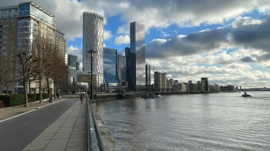
The Thames waterfront around Canary Wharf and the Isle of Dogs provides direct views of the river, modern buildings and historic dockland geography. Public promenades and riverside spaces reveal how waterways continue to influence transport, architecture, recreation and development across East London.
The River Thames remains a defining feature of Tower Hamlets. Its bends shaped the location of wharves, warehouses, docks and industrial facilities. Today, the same riverfront contains residential developments, office buildings, landscaped paths and transport infrastructure.
Riverside routes on the Isle of Dogs allow visitors to observe changes in land use along the water. Historic dock entrances and surviving industrial features sit within a landscape that includes modern apartment blocks and commercial buildings. This mixture reflects the gradual redevelopment of former port land.
The Thames also provides a wider view of London’s urban structure. Looking across the water reveals buildings on both banks, differences in architectural scale and the relationship between the river and the surrounding street network.
Visitors should distinguish publicly accessible riverside paths from private residential terraces and restricted development sites. Access varies along the river, so a continuous waterside route should not be assumed.
For a more informative visit, compare the riverfront with the inland streets. The waterfront highlights large-scale development and infrastructure, while nearby residential roads reveal the everyday services, shops and housing that support the district.
What can visitors see at Island Gardens and across the Thames?
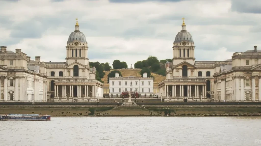
Island Gardens provides a public riverside park on the southern tip of the Isle of Dogs, with views across the Thames towards Greenwich. Its open lawns, mature trees and waterfront setting show how historic dockland neighbourhoods retain accessible green space beside modern development.
Island Gardens is one of the most recognisable places for observing the relationship between Tower Hamlets and Greenwich. The park faces the historic Greenwich waterfront, where the Old Royal Naval College and surrounding riverside buildings form a distinctive architectural scene.
The view offers a different perspective from Canary Wharf. Instead of looking upwards at a dense cluster of office towers, visitors see the river as an open space separating two historic parts of London. The contrast demonstrates how waterways connect neighbourhoods while also defining their physical boundaries.
The park is suitable for a quiet walk, riverside photography and observing river traffic. Its lawns and trees provide a natural foreground, while the opposite bank supplies architectural detail.
Island Gardens also helps visitors understand the importance of public open space in a densely developed borough. The London Borough of Tower Hamlets maintains a network of parks and green spaces, ranging from neighbourhood gardens to larger recreational areas.
The nearby Greenwich Foot Tunnel provides a pedestrian connection beneath the Thames, with entrances on both sides of the river. Visitors should check current access arrangements before travelling, particularly if accessibility or lift availability is important.
Island Gardens works well as part of a walking route through the Isle of Dogs. Combining the park with nearby residential streets and former dockland areas provides a broader picture of how the neighbourhood has changed.
Where can visitors explore the changing landscape of West India Quay?
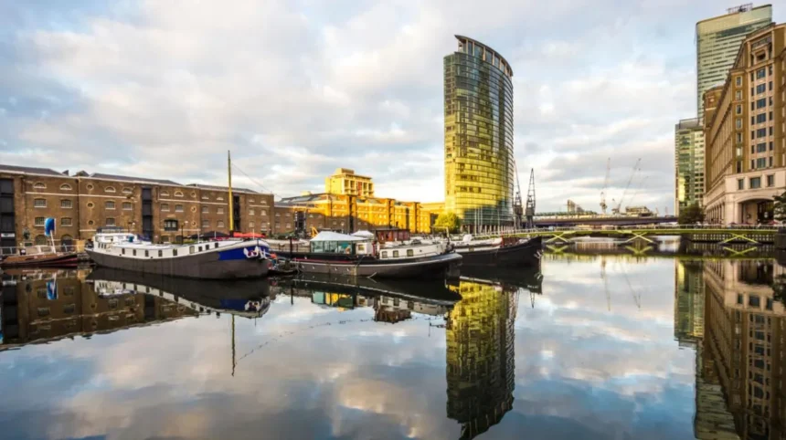
West India Quay combines surviving dockside warehouses, waterside walkways and contemporary buildings in one compact part of Tower Hamlets. The area demonstrates how historic commercial infrastructure has been adapted for museums, hospitality, leisure and public access while retaining connections to London’s maritime past.
West India Quay is one of the most useful locations for understanding the transition from working docks to a modern urban district. The surviving warehouse buildings provide a visible contrast with the surrounding office towers and residential developments.
The historic warehouses were built for the storage and handling of goods arriving through London’s port. Their substantial brick construction reflects the practical demands of nineteenth-century commercial activity. Today, the buildings contribute to the area’s architectural character and support new uses.
The London Museum Docklands, located in a historic warehouse at No. 1 Warehouse, explains the development of the port and its effects on London. Its galleries cover international trade, the experiences of dock workers, the history of slavery and the redevelopment of Docklands. The museum’s permanent galleries offer free entry, although visitors should check the official website for current opening details.
The quay itself provides a useful setting for observing the relationship between preserved industrial buildings and newer construction. Walk along the waterside and note how the scale, materials and layouts differ between historic warehouses and modern commercial buildings.
This is also a practical location for visitors who want to combine outdoor exploration with an indoor cultural visit. The nearby Canary Wharf and West India Quay transport links make it accessible without a car.
For historical context beyond the physical setting, explore the borough’s wider story through [Insert Anchor Text for Tower Hamlets History Article Here]. This single historical background link connects the modern waterfront to the trade, migration and industrial activity that shaped the area.
Where can visitors see Canary Wharf from a greener perspective?
Mudchute Park and Farm offers a distinctive view of Canary Wharf from open fields, trees and rural-style paths on the Isle of Dogs. Its 32-acre site combines an urban farm, wildlife habitats and walking routes, placing the modern skyline beside a contrasting landscape.
Mudchute is particularly useful for visitors who want to understand the contrast between urban development and open land. The farm occupies a substantial area of the Isle of Dogs, where residential buildings, transport links and commercial towers surround green spaces.
Its open landscape makes the Canary Wharf skyline easier to appreciate as a whole. Instead of standing directly beneath the towers, visitors can see their relationship with the surrounding neighbourhood and the remaining open land.
The site includes grazing fields, animal enclosures, trees and nature trails. The farm also supports educational activities and community programmes. Its rural character distinguishes it from the landscaped squares and paved promenades of the nearby business district.
Mudchute is a practical choice for families, photographers and visitors interested in urban ecology. It also demonstrates how a large green space provides a different experience from the compact public gardens associated with office developments.
Allow time to explore the walking paths rather than treating the farm only as a viewpoint. The changing angles reveal how vegetation, open land and modern buildings occupy the same urban environment.
Check the farm’s official visitor information before travelling, particularly for animal areas, facilities and opening times. Respect marked boundaries and avoid entering restricted areas to obtain photographs.
How does Mile End Park reveal changes in East London’s urban landscape?
Mile End Park reveals how former industrial land and areas affected by wartime bombing have been reshaped into a long public green corridor. Its canal paths, ecological spaces, recreation facilities and Green Bridge demonstrate how urban planning connects communities with nature.
Mile End Park follows a route between Limehouse and Victoria Park, linking different neighbourhoods through open space. The London Borough of Tower Hamlets describes it as a 32-hectare linear park, created across land that experienced industrial use and substantial damage during the Second World War.
The park provides a different way to observe urban change from the views around Canary Wharf. Instead of concentrating on tall buildings, it shows how green infrastructure, public recreation and ecological management influence the structure of a city.
The Green Bridge is one of its most distinctive features. Designed by architect Piers Gough, it opened in July 1999 and carries pedestrians and cyclists over Mile End Road. Trees, grass and planting create a green crossing over a busy traffic corridor.
The bridge addresses a common urban-planning problem: major roads divide public spaces and make walking between them difficult. Its design reconnects sections of the park while allowing traffic to continue below.
The Regent’s Canal towpath provides another useful route for observing the relationship between transport history and contemporary recreation. Visitors can compare the canal’s waterside environment with nearby roads, railway infrastructure, housing and sports facilities.
Mile End Park also contains ecology facilities, an Art Pavilion and recreational areas. These uses demonstrate how former industrial land supports public amenities and community activities.
For a longer walk, follow the park towards Limehouse or Victoria Park, checking the route and any local access restrictions before setting off. The park’s combination of green spaces, transport infrastructure and waterways makes it valuable for understanding the wider transformation of East London.
Which historic waterfront locations help explain Tower Hamlets’ modern skyline?
West India Quay, the Isle of Dogs and the surviving dockside landscapes help explain why Tower Hamlets looks different today. These locations connect historic maritime trade with modern office development, housing and transport, showing how former industrial sites have acquired new urban functions.
Tower Hamlets’ modern landscape reflects successive changes in employment, infrastructure and land use. The historic docks supported international trade and warehouse activity. As shipping patterns changed and traditional dock operations declined, large areas required new uses.
The redevelopment of London’s Docklands created space for commercial offices, homes, transport infrastructure and leisure facilities. Canary Wharf became one of the most visible outcomes, while surviving warehouses and dock basins retain evidence of the area’s earlier purpose.
West India Quay is a particularly accessible place to observe this relationship. The historic warehouse frontage stands beside a contemporary commercial district, making differences in building materials and architectural scale easy to identify.
Limehouse Basin offers another perspective on the historic relationship between waterways and urban transport. The basin connects the Regent’s Canal with the Limehouse Cut and the River Thames. Its marina and surrounding buildings demonstrate how former transport infrastructure now supports leisure boating, waterside walking and residential life.
These locations also reveal the limits of viewing regeneration only through new buildings. Changes to employment, housing, public access and the use of former industrial land are equally important. A modern skyline is one visible result of a much wider economic and social process.
Visitors interested in this transformation should combine outdoor exploration with a visit to the London Museum Docklands. Its historical interpretation provides context for the warehouses, dock basins and commercial buildings visible across the surrounding district.
Which public parks show how Tower Hamlets balances development with green space?
Tower Hamlets’ public parks reveal how green space remains part of a densely developed urban borough. Victoria Park, Mile End Park and Tower Hamlets Cemetery Park provide different environments for observing the relationship between historic landscapes, local communities, biodiversity and surrounding buildings.
The London Borough of Tower Hamlets manages a diverse network of parks and open spaces. The council reports more than 120 parks and green spaces across the borough, ranging from small gardens to major public parks. These spaces support recreation, community activities and nature conservation.
Victoria Park offers historic landscaping, lakes, mature trees and open lawns. Opened in 1845, it was established to provide public recreation for East London’s growing population. Its historic features and surrounding urban neighbourhoods illustrate how public parks became an important part of London’s development.
Tower Hamlets Cemetery Park presents a different landscape. The cemetery opened in 1841 and closed for burials in 1966 before becoming public open space. Today, it combines historic memorials, woodland paths and habitats for wildlife. It provides a quieter setting for examining how former institutional land can support conservation and public recreation.
These parks offer a useful contrast with Canary Wharf. Office towers and new residential buildings demonstrate intensive development, while parks show the importance of retaining accessible outdoor space within the urban environment.
Visitors should use designated paths, respect wildlife and check local notices before visiting. Park conditions, facilities and opening arrangements vary by location.
When is the best time to observe Tower Hamlets’ changing cityscape?
The best time to observe Tower Hamlets depends on the landscape being photographed or explored. Morning light suits waterfront walks, afternoon visits provide clear views of public spaces, and early evening reveals illuminated office buildings, changing river conditions and the transition from business activity to leisure.
The borough’s different environments produce different results throughout the day. Visitors planning a photography trip should consider the direction of sunlight, weather conditions, seasonal daylight and the accessibility of their chosen location.
Morning visits to Island Gardens provide an opportunity to explore the Greenwich-facing waterfront before the day becomes busy. The river and historic buildings create a distinctive composition, while the park offers space to stop without obstructing pedestrian routes.
Canary Wharf is particularly interesting during the transition between daylight and evening. Office towers reflect changing light, while illuminated buildings become more prominent as the surrounding public spaces grow darker. Crossrail Place Roof Garden provides an architectural setting, although visitors should check its closing time before planning a late visit.
West India Quay is useful during daylight hours because natural light makes the details of the historic warehouses easier to examine. The contrast between older brick buildings and newer towers becomes clearer when visitors can see their materials and proportions.
Weather also affects visibility. Clear conditions improve distant skyline views, while rain and low cloud alter the appearance of tall buildings. Wet pavements create reflections, but slippery paths require additional care.
Visitors should check current opening times, public transport services and any restrictions before travelling. Private terraces and commercial rooftops are not automatically open to the public, even when they offer attractive views.
Explore More Area Guide
Scenic Spots in Tower Hamlets for Visitors and Photographers
Best Quiet Places to Visit in Tower Hamlets, East London
How can visitors plan a walking route to see Tower Hamlets’ changing skyline?
A practical walking route connects Canary Wharf, Crossrail Place, West India Quay and selected riverside spaces. This approach combines contemporary architecture, historic dockland features and public green areas without requiring visitors to cross the entire borough in one trip.
A focused itinerary helps visitors compare different stages of urban development while keeping travel time manageable.
1. Start at Canada Square
Explore the office towers, public square and pedestrian routes. Observe how commercial buildings shape the central business district.
2. Visit Crossrail Place Roof Garden
Examine the relationship between transport infrastructure, architecture and planting. Check current opening hours before arrival.
3. Walk to West India Quay
Compare surviving warehouses with the modern buildings around the dock. Include the London Museum Docklands if you want historical context.
4. Finish at Island Gardens
Travel towards the southern end of the Isle of Dogs for open river views and a contrast with Canary Wharf’s dense skyline.
The route is best treated as a flexible itinerary rather than a guaranteed continuous riverside walk. Use the Docklands Light Railway (DLR), Jubilee line or Elizabeth line to shorten transfers where appropriate. The best connection depends on the order of your stops and current service conditions.
Visitors with limited time can concentrate on Canada Square, Crossrail Place and West India Quay. Those with a longer visit can add Mudchute Park and Farm or Island Gardens to see the skyline from a greener, more open setting.
Why are Tower Hamlets’ changing landscapes important to London’s future?
Tower Hamlets demonstrates how a major city adapts former industrial land to changing economic needs. Its combination of offices, housing, transport links, historic structures and public green spaces illustrates the importance of balancing development, heritage, environmental quality and public access.
The borough’s changing landscape is relevant beyond architecture and tourism. New buildings affect employment patterns, housing supply, transport demand and the use of public space. Regeneration also raises questions about affordability, local identity and the preservation of historic environments.
Canary Wharf represents the growth of a modern business district, while West India Quay retains visible evidence of the commercial port that preceded it. Island Gardens and Mudchute show how public open spaces remain part of this evolving urban structure.
Transport is another important element. The DLR, Jubilee line and Elizabeth line connect Tower Hamlets with other parts of London and influence how people access workplaces, homes and visitor destinations. The relationship between transport and development is particularly visible around Canary Wharf.
Public parks provide a complementary perspective. They offer recreation, ecological value and places for residents to spend time outside densely built commercial areas. The council’s network of parks demonstrates the continuing role of green infrastructure in the borough.
Visitors who explore several of these locations gain a broader understanding of urban change than they would from a single skyline photograph. The contrast between modern towers, historic warehouses, waterways and parks reveals how different periods of London’s history continue to shape the same neighbourhood.
Tower Hamlets is therefore a useful destination for anyone interested in the relationship between London’s past, present and future. Its public viewpoints and waterfront spaces make that transformation visible at street level, across the river and from the green spaces that remain within the city.
Where is the best place to see the changing skyline in Tower Hamlets?
Canary Wharf is one of the best places to observe Tower Hamlets’ changing skyline. Canada Square, Jubilee Park and Crossrail Place Roof Garden offer views of modern office towers, public spaces and contemporary architecture.