Stepney is a historic neighbourhood in the East End of London, within the London Borough of Tower Hamlets. Its character reflects centuries of migration, maritime trade, religious life, working-class communities and urban development. Visitors exploring Stepney encounter medieval church architecture, historic streets, community landmarks and cultural connections that explain how East London developed into one of the capital’s most diverse areas.
- What makes Stepney an important historic neighbourhood in East London?
- Which historic buildings should visitors explore in Stepney?
- Why is St Dunstan and All Saints Church significant to Stepney’s history?
- How did Stepney develop from a medieval settlement into an urban neighbourhood?
- What can visitors discover around Stepney Green?
- Which religious and cultural landmarks reflect Stepney’s diverse communities?
- What historic streets and conservation areas are worth exploring in Stepney?
- Where can visitors discover Stepney’s Jewish heritage?
- How did maritime trade and the docks influence Stepney?
- Which nearby attractions complement a visit to Stepney?
- How can visitors plan a walking tour of Stepney’s historic places?
- What is the best time to visit Stepney’s historic attractions?
- How does Stepney preserve its historic identity during modern development?
- Why should Stepney be included in an East London heritage itinerary?
The neighbourhood sits close to Whitechapel, Limehouse, Mile End and Bethnal Green. This location makes Stepney a useful starting point for visitors interested in London’s history beyond the major attractions of central London. Its heritage is visible in surviving buildings, religious institutions, street layouts and the relationship between older residential areas and modern regeneration.
What makes Stepney an important historic neighbourhood in East London?
Stepney is an established East London neighbourhood known for its medieval parish heritage, historic churches, maritime connections and long history of migration. Its buildings and streets reveal how religious institutions, trade, housing and community life shaped the wider East End over several centuries.
Stepney developed as part of the historic county of Middlesex before becoming incorporated into the expanding urban area of London. Its historical identity is closely associated with Stepney parish, an extensive ecclesiastical area that once covered settlements now recognised as separate East London neighbourhoods.
The historic parish included land associated with Whitechapel, Bethnal Green, Poplar, Limehouse and other surrounding districts. As London expanded, population growth and administrative changes divided this wider area into smaller local communities.
Stepney’s development followed several interconnected patterns. Agriculture and rural settlement characterised its earlier history, while London’s expansion increased demand for housing, transport and commercial activity. Its position near the River Thames and the docks also connected the wider district to international trade.
The neighbourhood subsequently became home to successive immigrant communities, including Jewish families arriving from Eastern Europe and, later, substantial Bangladeshi communities. These communities established businesses, religious institutions, cultural organisations and social networks that continue to influence the area.
Stepney therefore represents more than a collection of old buildings. It provides a way to understand the changing relationship between London’s historic institutions, industrial development, migration and modern urban life.
Which historic buildings should visitors explore in Stepney?
Visitors interested in Stepney’s historic architecture should begin with St Dunstan and All Saints Church, then explore surviving historic streets and nearby religious landmarks. These locations demonstrate the neighbourhood’s medieval origins, changing architectural character and enduring importance within East London.
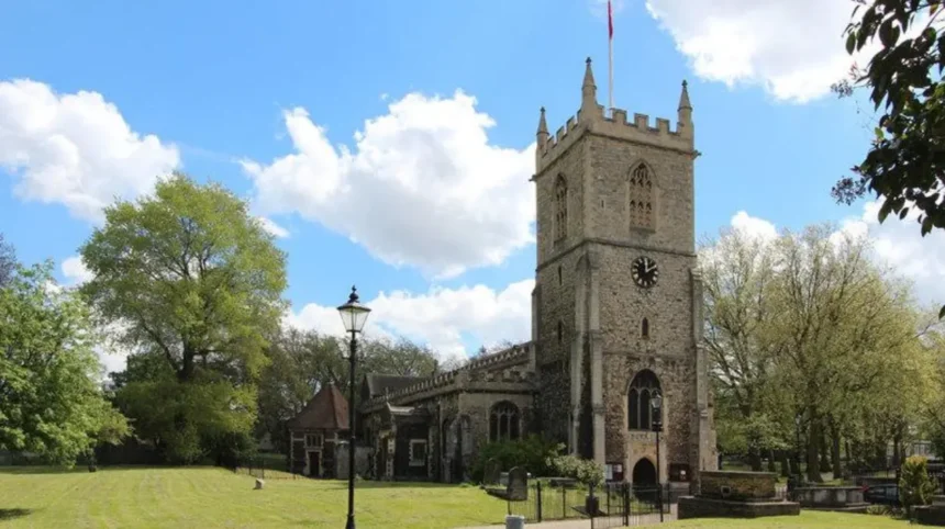
St Dunstan and All Saints Church is the most prominent historic landmark associated with Stepney. The church stands on Stepney High Street and has roots extending back to the medieval period. Its surviving fabric, churchyard and long-standing parish role make it an important destination for visitors interested in London’s religious history.
The church is traditionally associated with the year 952, when a church at Stepney was reportedly established or recorded in historical accounts. The present building incorporates medieval elements, including a substantial tower, while other sections reflect subsequent alterations and restoration.
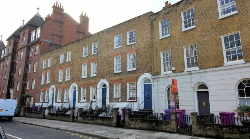
The surrounding area also contains residential buildings that illustrate the architectural changes accompanying London’s growth. Georgian houses, Victorian terraces and later housing developments demonstrate how the neighbourhood evolved as its population increased.
Stepney Green is particularly relevant to this architectural history. Its open space and nearby buildings provide a contrast to the denser streets around Whitechapel Road and Commercial Road.
Visitors should distinguish between buildings within Stepney itself and landmarks in neighbouring districts. Whitechapel, Limehouse and Mile End all contain important heritage sites, but each has a separate local identity. Planning a walking route around Stepney’s historic core helps visitors appreciate these distinctions.
Why is St Dunstan and All Saints Church significant to Stepney’s history?
St Dunstan and All Saints Church is a landmark of Stepney’s medieval parish history. Its historic tower, churchyard and continuing religious role connect present-day East London with centuries of worship, local administration and community life.
St Dunstan and All Saints Church is often described as the historic parish church of Stepney. Its significance comes from its long association with the local population and the wider parish that once extended across much of the East End.
The church’s history predates many of the streets and residential developments surrounding it today. Over time, rebuilding, repairs and changes in religious practice altered the structure, while its continued use preserved its place in local life.
The church tower is a particularly recognisable feature. Historic churches often served as both religious buildings and local landmarks, helping residents identify the centre of their community before modern transport networks and street signage became widespread.
The churchyard adds another historical dimension. Burial grounds associated with old parish churches provide evidence of earlier generations and the social history of the surrounding settlement. Visitors should respect the church’s religious function and follow any restrictions on photography, access or visiting hours.
The site also helps explain the relationship between medieval institutions and modern neighbourhoods. Although administrative boundaries changed as London grew, the church remained a physical link to Stepney’s earlier identity.
For a wider understanding of how the neighbourhood developed, this landmark should be considered alongside Stepney’s housing history, the growth of the docks and the arrival of successive migrant communities.
How did Stepney develop from a medieval settlement into an urban neighbourhood?
Stepney developed from a historically extensive parish into a densely settled part of East London as the capital expanded. Agricultural land, religious institutions, transport routes, dock employment and residential construction all contributed to its transformation from rural surroundings into an urban neighbourhood.
During the medieval period, Stepney formed part of the landscape beyond the densely built centre of London. Its parish served communities spread across a broad area, reflecting the importance of the church in organising local life.
London’s growth gradually changed this landscape. Population expansion increased demand for homes and services, while roads connected the East End more closely with the commercial centre and the River Thames.
The development of docks and riverside industries in the wider East End created employment in shipping, warehousing, manufacturing and associated trades. Workers settled in accessible residential districts, and the demand for affordable housing encouraged dense construction.
During the nineteenth century, Stepney became part of a rapidly industrialising urban environment. Terraced housing, commercial premises and local institutions accommodated a growing population. Crowded living conditions and poverty also became significant concerns in parts of the East End, prompting later public health and housing reforms.
The twentieth century brought further changes through wartime destruction, post-war rebuilding, changes in industry and the decline of traditional dock employment. New housing developments reshaped parts of Stepney, while migration introduced new languages, businesses and cultural institutions.
Today, Stepney combines surviving historic structures with modern residential buildings and community facilities. Its present-day character reflects these overlapping periods rather than one single architectural or historical era.
For readers researching the area’s deeper origins, the article on [Stepney’s history and historical development] provides a dedicated background link connecting the neighbourhood’s medieval roots with its modern identity.
What can visitors discover around Stepney Green?
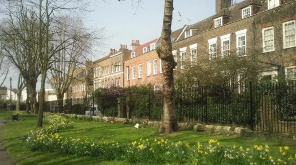
Stepney Green offers visitors an open public space surrounded by residential streets and historic buildings. It provides a practical starting point for exploring the neighbourhood on foot, observing local architecture and understanding the relationship between green space and urban development.
Stepney Green is a useful stop for travellers who want to explore East London at a slower pace. Unlike major tourist destinations built around a single attraction, the area rewards attention to its streetscape, housing and everyday community life.
The green itself offers space to pause between visits to historic landmarks. Its surroundings include residential buildings from different periods, helping visitors recognise changes in building materials, architectural styles and urban planning.
The area’s open space also illustrates how public green areas function within densely populated neighbourhoods. Parks and greens provide opportunities for walking, sitting and informal recreation while preserving a visible connection between the built environment and outdoor space.
Visitors should plan their route around pedestrian access and the location of nearby transport stops. Stepney Green Underground station serves the District and Hammersmith & City lines, providing connections with other parts of London. The station is distinct from Stepney Green itself, which refers to the open space and surrounding neighbourhood.
A short visit can be combined with St Dunstan and All Saints Church and a walk towards Whitechapel or Mile End. This creates a compact itinerary without requiring extensive travel between attractions.
Which religious and cultural landmarks reflect Stepney’s diverse communities?
Stepney’s religious and cultural landscape reflects centuries of social change, including Christian parish life, Jewish migration and the growth of Bangladeshi communities. Historic churches, nearby synagogues and local mosques provide context for understanding the East End’s changing population.
St Dunstan and All Saints Church represents Stepney’s long-established Christian heritage. Its continuing religious function connects the neighbourhood with the parish structures that shaped local life before modern borough boundaries existed.
Jewish migration significantly influenced the wider East End during the nineteenth and early twentieth centuries. Families arriving from Eastern Europe established religious institutions, shops, mutual-aid organisations and cultural networks in districts including Whitechapel and Stepney. These communities helped shape local commerce and political life.
Bangladeshi migration became another defining influence, particularly from the mid-twentieth century onwards. Bangladeshi residents established businesses, restaurants, mosques, community associations and educational initiatives throughout Tower Hamlets. The wider Whitechapel and Brick Lane areas are especially associated with this heritage.
Religious buildings provide a useful way to explore these histories, but visitors should distinguish between Stepney’s own landmarks and sites located in neighbouring districts. A mosque or synagogue in Whitechapel is part of the broader East End cultural landscape rather than necessarily being within Stepney’s historic centre.
Visitors should check opening arrangements before entering active religious buildings. Modest clothing, quiet behaviour and respect for worshippers are appropriate. Some sites welcome visitors outside prayer times, while others restrict access to worshippers or organised groups.
These landmarks demonstrate how migration shaped local identity. They also show that East London’s history extends beyond industrialisation to include faith, education, family networks and the development of community institutions.
What historic streets and conservation areas are worth exploring in Stepney?
Stepney’s conservation areas preserve historic residential streets, architectural details and public spaces that reveal the neighbourhood’s development. Stepney Green, York Square, Carlton Square and Albert Gardens offer useful examples of how Georgian and Victorian buildings survive within modern East London.
A conservation area is a designated location recognised for its special architectural or historic interest. Tower Hamlets Council manages conservation areas through planning policies intended to preserve or enhance their distinctive character. The borough has 58 conservation areas, including Stepney Green and several other historic locations.
Stepney Green Conservation Area is particularly relevant to visitors interested in historic residential architecture. Its character includes mature trees, period houses, mansion blocks and buildings along Mile End Road. The contrast between these structures and nearby post-war housing illustrates the neighbourhood’s changing development.
York Square provides another useful location for observing historic residential streets. Its relationship with St Dunstan and All Saints Church connects the area’s built environment with Stepney’s religious history.
Carlton Square and Albert Gardens offer additional examples of historic housing and planned residential spaces. Their architectural character reflects periods when residential squares and terraces formed important parts of London’s urban expansion.
Visitors should explore these areas respectfully. Many historic houses remain private homes rather than visitor attractions. The most appropriate activities include viewing façades from public pavements, observing architectural details and following established walking routes.
Photographs of doorways, brickwork, windows and rooflines help document differences between building periods. Visitors should avoid entering private gardens or courtyards without permission.
Where can visitors discover Stepney’s Jewish heritage?
Stepney’s Jewish heritage is visible in the former East London Synagogue, historic educational buildings and the wider East End’s migration history. These places document how Jewish communities established religious, educational and commercial institutions during periods of major social change.
The former East London Synagogue at 52 Rectory Square is an important heritage site associated with the area’s Jewish community. The building dates from 1877 and is Grade II listed, reflecting its recognised architectural and historical significance. Its former religious use provides evidence of the institutions established by Jewish residents in the East End.
The building’s history is part of a wider story of migration. During the nineteenth and early twentieth centuries, Jewish families arriving from Eastern Europe settled in East London and developed synagogues, schools, businesses and charitable organisations.
These institutions provided more than places of worship. Schools supported education, community organisations offered assistance to families, and local businesses helped sustain neighbourhood economies.
The former Stepney Jewish Primary and Infants School, built in 1906, provides another example of this history. Following its closure in the 1960s, the building was converted into artists’ studios, demonstrating how a historic institutional building acquired a different use.
These buildings also demonstrate how heritage survives when a building’s original function changes. Historic structures remain part of the neighbourhood’s identity even when their occupants, activities or ownership arrangements change.
Visitors should confirm current access arrangements before planning a visit. The former synagogue is now used as apartments, so it is not a public synagogue or an ordinary visitor attraction. Its exterior and documented history are the appropriate focus for independent heritage exploration.
How did maritime trade and the docks influence Stepney?
Maritime trade shaped Stepney through employment, population growth and migration across the wider East End. Nearby docks attracted sailors, warehouse workers and traders, while riverside industries helped create demand for housing, shops and community institutions in surrounding neighbourhoods.
Stepney’s proximity to the River Thames placed it within the wider commercial environment of London’s historic port. During the expansion of maritime trade, docks and warehouses employed people in loading cargo, transporting goods, repairing vessels and supporting shipping operations.
The commercial importance of the river extended beyond the immediate waterfront. Workers needed places to live, eat, shop and access public services. Stepney’s residential streets formed part of the urban landscape supporting this wider economy.
Maritime employment also connected East London to international migration. Bengali sailors, often described historically as lascars, worked on commercial ships and developed connections with communities around London’s docks. Over time, Bengali migration contributed to the cultural and social development of Stepney and neighbouring districts.
The decline of traditional dock employment during the twentieth century changed the local economy. Mechanisation, containerisation and the relocation of port activities transformed the docks and reduced demand for some forms of traditional labour.
Later redevelopment introduced new housing, commercial buildings and employment opportunities across the wider Docklands area. Stepney’s own development also reflected post-war rebuilding and changes in housing policy.
Understanding this maritime background helps explain why Stepney’s history includes both local residential life and international connections. The neighbourhood was never isolated from wider economic changes; its growth reflected London’s role as a major trading city.
Which nearby attractions complement a visit to Stepney?
Visitors can extend a Stepney heritage walk into nearby Whitechapel, Mile End and Limehouse. These neighbouring districts offer additional historic streets, cultural landmarks, green spaces and transport connections that place Stepney’s history within the wider East London landscape.
Whitechapel lies west of Stepney and offers a useful extension for visitors interested in migration history, street markets and the development of East London’s commercial districts. Its historic streets and cultural institutions complement Stepney’s residential and religious heritage.
Mile End provides access to green space and further connections with the area’s historic transport routes. Mile End Park offers open space for walking and relaxation, making it suitable for visitors who want to balance architectural exploration with time outdoors.
Limehouse offers a different perspective through its historic relationship with the Thames and maritime trade. Narrow Street and the surrounding riverside environment help illustrate how shipping, warehouses and dock-related industries influenced the development of East London.
Brick Lane, in the wider Spitalfields and Whitechapel area, is associated with successive migrant communities, independent businesses and Bangladeshi cultural heritage. It is especially relevant to visitors interested in the connections between migration, food and urban identity.
These districts should be treated as separate destinations within the wider East End rather than as interchangeable parts of Stepney. Their proximity makes it possible to combine several locations in a day, but the amount of walking depends on the chosen route and the time spent at each stop.
A practical itinerary starts at St Dunstan and All Saints Church, continues through Stepney Green and nearby historic squares, and then moves towards Whitechapel or Mile End. Visitors with more time can add Limehouse as a separate section of the day.
How can visitors plan a walking tour of Stepney’s historic places?
A walking tour of Stepney works best when it connects St Dunstan and All Saints Church, Stepney Green, historic residential squares and nearby cultural landmarks. A planned route reduces unnecessary backtracking and gives visitors time to appreciate the area’s architectural and social history.
Start at St Dunstan and All Saints Church, the neighbourhood’s principal historic landmark. Check the church’s official website for opening times before travelling, as access depends on its service schedule and other activities.
Continue towards Stepney Green to examine the relationship between public space and historic residential architecture. From there, explore nearby streets and squares, including York Square, where the surrounding buildings provide further examples of the area’s architectural heritage.
A suggested itinerary includes these stops:
- St Dunstan and All Saints Church: Begin with the medieval parish church and its historic tower.
- Stepney Green: Explore the public green and the surrounding residential streets.
- York Square: Observe historic houses and the relationship between architecture and the church.
- Rectory Square: Learn about the former East London Synagogue and Stepney’s Jewish heritage from the public street.
- Whitechapel: Extend the visit to explore the wider East End’s commercial and cultural history.
The route should be adapted to individual interests, available time and mobility requirements. Visitors concentrating on architecture can spend longer around Stepney Green, while those interested in migration history can extend their walk towards Whitechapel.
Wear comfortable footwear and allow time for crossings, rest stops and checking directions. Stepney’s historic sites sit within an active residential neighbourhood, so pavements, roads and public spaces remain part of everyday community life.
For a more detailed visit, consult Tower Hamlets Council’s conservation guidance and Historic England’s building records. These sources help distinguish officially listed heritage buildings from structures that are historically interesting but do not have statutory listing.
What is the best time to visit Stepney’s historic attractions?
Spring and summer provide longer daylight hours for exploring Stepney’s streets, churchyard and green spaces. Autumn and winter remain suitable for architectural walks, although visitors should check daylight, weather conditions and opening arrangements before setting out.
Stepney is an urban neighbourhood rather than a single ticketed attraction with one operating season. Most independent walking routes depend on access to public streets and open spaces, while individual buildings have their own visiting arrangements.
Spring is suitable for observing mature trees and landscaped public spaces. Summer offers longer daylight hours, which help visitors combine Stepney with neighbouring East London districts. Autumn provides opportunities to examine architectural details without the same emphasis on outdoor recreation.
Winter visits require more attention to daylight and weather. Historic building façades remain visible, but wet pavements and reduced daylight can affect walking routes. Visitors should plan outdoor sections accordingly.
The church’s published schedule is a useful starting point for anyone who wants to enter St Dunstan and All Saints rather than view it from outside. Its official website lists regular services and weekday opening arrangements, subject to schedule changes.
There is no single best month for every visitor. Architecture enthusiasts can visit throughout the year, while those planning longer walks benefit from checking local conditions and allowing sufficient time to return to their transport connection.
Explore More Area Guide
Mile End Guide: Parks, Heritage and London Attractions
Exploring Wapping: Historic Riverside Heritage in Tower Hamlets
How does Stepney preserve its historic identity during modern development?
Stepney preserves its historic identity through listed buildings, conservation areas, surviving public spaces and the continued use of older structures. Local planning policies help protect architectural character while allowing buildings and neighbourhoods to respond to changing housing and community needs.
Historic preservation is the process of protecting buildings, places and features that have architectural, cultural or historical significance. In Stepney, this includes medieval religious architecture, historic housing and buildings associated with the neighbourhood’s social history.
Tower Hamlets Council identifies conservation areas as locations of special architectural or historic interest. Its planning framework aims to preserve or enhance their character, while listed-building controls provide additional protection for buildings of recognised national importance.
These protections matter because Stepney’s historic environment is not limited to isolated monuments. Its character also depends on relationships between buildings, streets, gardens and open spaces.
Modern development presents practical challenges. The neighbourhood needs homes, transport infrastructure and community facilities, but redevelopment can also change historic streetscapes. Conservation policies help planning authorities assess the effects of proposals on buildings and their surroundings.
The reuse of historic buildings offers one way to retain their physical character while accommodating new functions. The conversion of the former Stepney Jewish Primary and Infants School into artists’ studios illustrates how a building can continue to contribute to local life after its original educational purpose ends.
Visitors also contribute to heritage awareness by learning about local history and respecting the places they explore. Responsible tourism includes keeping public areas clean, respecting private property and recognising that historic streets remain living residential environments.
Stepney’s future identity will depend on how its architectural heritage, community institutions and housing needs are managed together. Its historic character remains relevant because it documents the processes that shaped East London and continues to inform how the neighbourhood is understood.
Why should Stepney be included in an East London heritage itinerary?
Stepney deserves a place on an East London heritage itinerary because it connects medieval parish history, historic residential architecture, religious landmarks and migration. Its compact historic core offers visitors a practical way to understand the social and architectural changes that shaped the East End.
The neighbourhood’s most important attraction is the relationship between its different historical layers. St Dunstan and All Saints Church represents its medieval origins, while Stepney Green and nearby squares illustrate later residential development. The former East London Synagogue and historic school buildings document the area’s changing religious and cultural communities.
Stepney also provides context for understanding the growth of London’s docks, the movement of workers and the development of dense urban housing. These themes connect its local history with wider changes in London’s economy and population.
For first-time visitors, the best approach is to concentrate on the historic core before extending the journey into Whitechapel, Mile End or Limehouse. This keeps the visit manageable while allowing additional exploration according to personal interests.
The neighbourhood suits travellers who value historic architecture, social history and independent walking routes. It also offers residents an opportunity to explore local heritage beyond the better-known attractions of central London.
Stepney’s significance rests on its surviving buildings, changing communities and place within the development of East London. Exploring these features provides a clearer understanding of the area’s past and the forces that continue to shape its present.
What are the best historic places to visit in Stepney?
The best historic places include St Dunstan and All Saints Church, Stepney Green, York Square and historic residential streets that reflect East London’s architectural heritage.