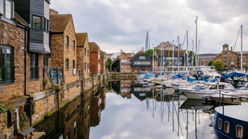
East London’s riverside heritage centres on the River Thames, the historic Port of London, former docks, maritime trade, riverside warehouses and the communities that shaped Tower Hamlets. Located in the East End of London, the borough combines centuries of waterfront history with modern residential developments, cultural attractions, public walking routes and working commercial spaces.
- What Makes Tower Hamlets Important to East London’s Riverside Heritage?
- How Did the River Thames Shape Tower Hamlets’ History?
- Which Historic Docks Can Visitors Explore in Tower Hamlets?
- Where Can Visitors Discover Historic Riverside Architecture in Wapping?
- What Can Visitors Learn About Maritime History at the Museum of London Docklands?
- How Did Canary Wharf Transform East London’s Riverside Landscape?
- Which Riverside Walks Connect Tower Hamlets’ Historic Sites?
- What Is the Significance of Limehouse Basin in East London’s Maritime History?
- How Does East India Dock Basin Combine Heritage and Wildlife?
- What Does Tower Hamlets’ Riverside Architecture Reveal About Trade and Industry?
- How Did International Trade and Migration Shape Tower Hamlets’ Riverside Communities?
- How Can Visitors Plan a Riverside Heritage Walk Around Tower Hamlets?
- When Is the Best Time to Explore Tower Hamlets’ Riverside Heritage?
- Why Is Tower Hamlets’ Riverside Heritage Important to East London’s Future?
For tourists and leisure travellers, Tower Hamlets provides access to historic riverside districts, dockland architecture, museums and waterfront viewpoints. Canary Wharf, Limehouse, Wapping and the Isle of Dogs each reveal a different part of East London’s relationship with the river. Their buildings and public spaces explain how maritime commerce transformed the area and influenced London’s development.
The borough’s riverside heritage also connects industrial history with contemporary city life. Former docks now accommodate offices, homes, restaurants and cultural venues, while surviving historic buildings preserve evidence of the port’s commercial past. Exploring these locations on foot provides a practical way to understand the relationship between London’s river, its economy and its communities.
What Makes Tower Hamlets Important to East London’s Riverside Heritage?
Tower Hamlets is important to East London’s riverside heritage because its Thames-side districts supported maritime trade, dock operations, ship-related industries and international commerce. Historic warehouses, dock basins, converted industrial buildings and surviving waterfront streets explain how the river shaped the borough’s economy and urban development.
Tower Hamlets occupies a strategic position along the northern bank of the River Thames. Its riverside geography includes Wapping, Limehouse, the Isle of Dogs and parts of the historic docklands around Poplar. These districts developed through their proximity to shipping routes, wharves, warehouses and commercial facilities.
The river provided transport for goods entering and leaving London. Ships carried commodities from British ports and overseas trading centres. Dock workers, warehouse employees, merchants, sailors and manufacturers supported the industries surrounding the waterfront.
The Port of London became one of the most important commercial gateways in Britain. Its growth increased demand for enclosed docks, secure storage facilities and efficient connections between ships, warehouses and inland markets.
Tower Hamlets retains evidence of this development in its street layouts, surviving industrial structures and former dock entrances. These features help visitors distinguish the borough’s maritime heritage from the more recent office towers and residential buildings surrounding the waterfront.
The area is also important because its history reflects changes in employment, migration and urban planning. Port expansion attracted workers from different parts of Britain and overseas. Their communities contributed to the cultural identity of the East End.
How Did the River Thames Shape Tower Hamlets’ History?
The River Thames shaped Tower Hamlets by providing a transport route for goods, supporting waterfront employment and encouraging the development of docks and warehouses. From early riverside settlements to the expansion of commercial shipping, the river influenced local industry, population growth and urban planning.
The Thames served as a major transport corridor long before modern road and railway networks developed. Its navigable waters connected London with other British ports and international maritime routes. Riverside settlements benefited from access to ships, cargo and commercial activity.
During the medieval period, riverside communities in the East End supported fishing, boatbuilding, trading and other activities connected with the water. As London expanded, the demand for imported goods increased. The riverside became an increasingly important location for commercial storage and distribution.
By the eighteenth century, congestion on the Thames had become a major problem for shipping. Ships often waited in the river to unload cargo, while merchants faced difficulties protecting valuable goods. These pressures encouraged the construction of enclosed commercial docks.
The West India Docks opened in 1802 on the Isle of Dogs. Built to handle expanding overseas trade, they introduced enclosed basins, controlled entrances and substantial warehouse facilities. The docks strengthened the area’s role in Britain’s maritime economy.
The river also influenced the location of roads, industrial premises and workers’ housing. Streets developed around dock entrances, wharves and routes used to move goods. This relationship between waterways and urban infrastructure remains visible throughout the historic docklands.
To understand the longer development of the neighbourhoods visitors encounter today, explore the [Insert Anchor Text for Tower Hamlets History Article Here] for the wider historical background behind East London’s changing identity.
Which Historic Docks Can Visitors Explore in Tower Hamlets?
Visitors exploring Tower Hamlets’ historic docks should focus on West India Docks, Millwall Dock and the surviving dock basins around Canary Wharf and the Isle of Dogs. These locations demonstrate how enclosed waterways supported cargo handling, warehouse storage and London’s international trading economy.
West India Docks
The West India Docks opened in 1802 to improve the handling and security of imported goods. Their construction transformed the Isle of Dogs into a major commercial district. Today, surviving dock basins and surrounding buildings provide a clear view of the area’s transition from port facilities to a modern business centre.
Millwall Dock
Millwall Dock opened in 1868 and expanded the commercial infrastructure of the Isle of Dogs. Its water basins and surrounding industrial land supported shipping and cargo operations. The district now contains residential developments and modern infrastructure alongside reminders of its dockland origins.
West India Quay
West India Quay preserves historic dockside warehouses associated with the West India Docks. The buildings illustrate the importance of secure storage for goods arriving by sea. Their location beside the former commercial waterways makes this area a useful starting point for understanding the architecture of London’s historic port.
These locations show how dock infrastructure operated as part of a connected system. Ships entered enclosed basins, cargo moved to warehouses and merchants distributed goods through London and beyond.
The surviving water basins also explain why modern redevelopment has retained many historic dock layouts. The original waterways remain defining features of the urban landscape even where their commercial function has changed.
Visitors should distinguish between historic dock structures and newer waterfront buildings. Modern towers represent the financial and commercial economy that developed after the decline of traditional dock employment, while the basins and warehouses preserve the area’s maritime character.
Where Can Visitors Discover Historic Riverside Architecture in Wapping?
Wapping is one of Tower Hamlets’ most distinctive historic riverside districts. Its narrow streets, former warehouses, old wharf buildings and Thames-side pathways preserve the physical character of a neighbourhood shaped by shipping, maritime employment and riverside commerce.
Wapping developed close to the Thames, where shipping and port-related employment shaped everyday life. The neighbourhood’s built environment reflects the need for access to the river, storage for cargo and accommodation for people working in maritime industries.
Historic warehouses are among the most recognisable features of Wapping. Their robust brickwork, large openings and substantial construction reflect the practical requirements of commercial storage. Some former industrial buildings have been converted into residential properties, restaurants and other uses.
Wapping High Street provides a route through the neighbourhood, connecting historic streets with sections of the waterfront. The surrounding lanes reveal a more intimate urban landscape than the large commercial developments found farther east around Canary Wharf.
The river-facing buildings also help visitors understand the relationship between private industry and public space. Former wharves served commercial purposes, whereas modern riverside paths provide opportunities for walking and viewing the Thames.
Wapping is particularly useful for travellers interested in architectural change. Its buildings show how historic industrial premises can retain their original character while accommodating contemporary uses.
Access to individual waterfront sections varies because some riverside areas remain privately managed. Visitors should follow public footpaths and respect residential access restrictions.
What Can Visitors Learn About Maritime History at the Museum of London Docklands?
The Museum of London Docklands explains how the River Thames, the Port of London, overseas trade, migration and dock employment shaped the capital. Its collections and exhibitions provide historical context for the warehouses, dock basins and industrial landscapes that visitors encounter across Tower Hamlets.
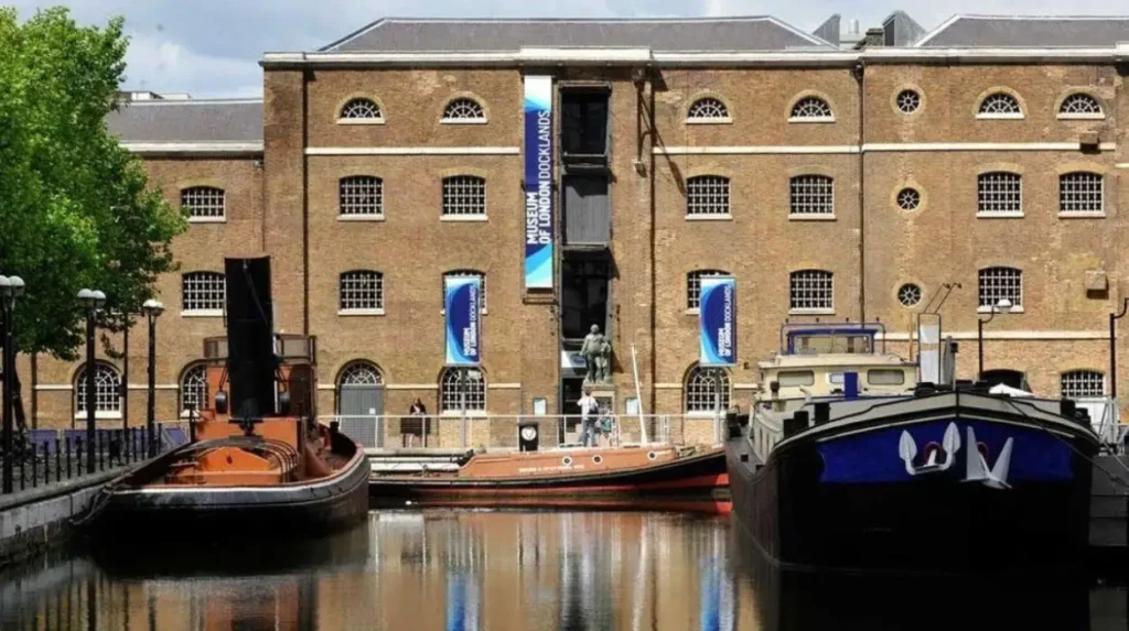
The Museum of London Docklands occupies a historic warehouse at West India Quay. The building itself forms part of the story because it demonstrates how commercial structures were designed to support the storage and distribution of imported goods.
The museum examines the development of the Port of London from its early trading history through the expansion of the docks and the transformation of the waterfront. Its subject matter includes international commerce, slavery and the Atlantic economy, industrialisation, dock labour and migration.
This historical context is essential for understanding the wider significance of Tower Hamlets. The borough’s riverside buildings were not isolated structures. They belonged to a commercial network connecting London with ports and communities across the world.
The museum also helps visitors understand the human consequences of maritime trade. Dock employment shaped family life, housing demand and neighbourhood identity. Changes in shipping technology and cargo handling eventually reduced demand for many traditional dock jobs.
Visitors should check the museum’s official visitor information for current opening hours, admission arrangements and exhibition details before travelling. Museum displays and temporary exhibitions change over time.
For travellers with limited time, the museum provides a useful introduction before exploring West India Quay, Canary Wharf or the historic streets around Wapping.
How Did Canary Wharf Transform East London’s Riverside Landscape?
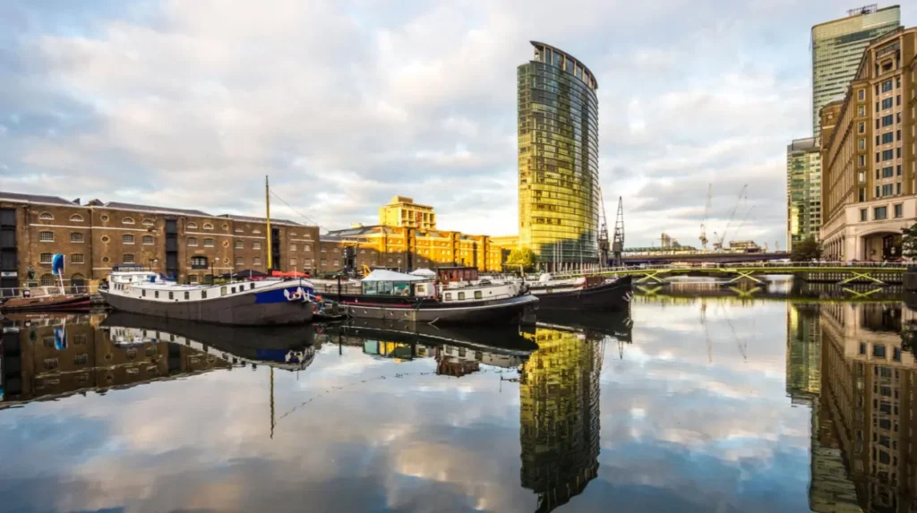
Canary Wharf transformed East London’s riverside landscape by redeveloping former dockland into a major financial and commercial district. Its office towers, public spaces, shopping facilities and retained dock basins demonstrate the shift from traditional port employment towards finance, professional services and contemporary urban living.
Canary Wharf stands on the Isle of Dogs, where the West India Docks once supported substantial maritime trade. The decline of traditional commercial shipping during the twentieth century left large areas of dockland available for redevelopment.
The London Docklands Development Corporation was established in 1981 to encourage regeneration in the former docklands of East London. Its work supported changes to land use, infrastructure and investment across the wider area.
Canary Wharf subsequently emerged as a major business district. Office towers, transport connections, shops and public spaces reshaped the former industrial landscape. The district now forms an important part of London’s financial services economy.
The relationship between historic docks and modern buildings is particularly visible around the retained waterways. Dock basins continue to provide open water spaces among large commercial structures. This arrangement preserves a recognisable feature of the former port while supporting contemporary urban activity.
Visitors can explore publicly accessible waterfront areas, view the skyline and follow pedestrian routes around the docks. The area also offers cafés, restaurants and indoor facilities for travellers taking a break from sightseeing.
Canary Wharf demonstrates that riverside heritage includes more than preserved historic buildings. The surviving water infrastructure and the pattern of development reveal how the same location has served different economic purposes across successive generations.
Which Riverside Walks Connect Tower Hamlets’ Historic Sites?
Riverside walks in Tower Hamlets connect historic streets, former warehouses, dock basins and modern waterfront developments. Useful areas include Wapping, Limehouse Basin, West India Quay and Canary Wharf, where publicly accessible paths provide opportunities to explore the Thames and dockland heritage.
The Thames Path is a long-distance walking route that follows sections of the River Thames through London and other parts of southern England. In Tower Hamlets, riverside sections give visitors access to historic waterfront districts and views across the river.
Wapping is suited to visitors interested in older streets, former wharves and warehouse architecture. Its riverside environment provides a direct connection between the historic built landscape and the river that supported its development.
Limehouse offers a different perspective. Limehouse Basin connects the Regent’s Canal with the Thames through a historic dock and marina environment. The basin illustrates the relationship between river transport and London’s inland canal network.
West India Quay connects historic warehouses with the commercial district around Canary Wharf. Visitors can compare preserved dockland buildings with modern offices without travelling far between the two environments.
The Isle of Dogs provides further opportunities to explore retained dock basins and landscaped waterfront spaces. The route chosen depends on the available time, mobility requirements and access to particular riverside sections.
Before setting out, check current pedestrian access and any local restrictions. Some sections of the riverbank pass through privately managed property or close to working infrastructure, so a continuous uninterrupted riverside route is not guaranteed.
What Is the Significance of Limehouse Basin in East London’s Maritime History?
Limehouse Basin is historically significant because it connected the River Thames with London’s inland canal network. Formerly known as Regent’s Canal Dock, it transferred goods between seagoing vessels and canal boats. Today, its marina, waterways and pedestrian surroundings preserve this transport heritage.
Limehouse Basin occupies a strategic position between the Thames and Regent’s Canal. Its connection to the inland waterways enabled cargo to move between ships arriving at London and destinations farther inland.
The basin supported a transport system that linked river shipping with canal infrastructure. Goods arriving by sea transferred to smaller vessels for distribution through the canal network. This reduced dependence on congested streets and connected London’s port with other commercial areas.
The surrounding neighbourhood developed around maritime employment, warehouses and transport facilities. Narrow Street preserves elements of the area’s historic street pattern, while the marina introduces a contemporary recreational use for the water.
The basin now accommodates narrowboats, yachts and visiting pleasure craft. Its lock and swing bridge demonstrate the practical requirements of managing vessel movements between waterways and roads.
The Canal & River Trust provides visitor information and explains the basin’s role within the wider canal network. The area is accessible from Limehouse DLR station, making it a convenient stop for visitors travelling without a car.
Limehouse Basin also illustrates a wider theme in Tower Hamlets: historic transport infrastructure remains relevant after its original commercial function changes. The waterways now support leisure, residential activity and walking routes while retaining their connection to London’s industrial development.
How Does East India Dock Basin Combine Heritage and Wildlife?
East India Dock Basin combines maritime heritage with an urban nature reserve. The former commercial dock in Tower Hamlets now supports wildlife, wildflower meadows and salt-marsh habitat, while its location beside the Thames preserves a visible connection with East London’s historic shipping industry.
East India Dock Basin served ships associated with the East India Company and Britain’s overseas trading networks. Its original function reflected London’s demand for facilities that handled cargo arriving from international markets.
The former dock has a different purpose today. The site is recognised as a nature reserve, with habitats that include wildflower meadows and salt marsh. These features provide an ecological contrast with the surrounding roads, commercial buildings and residential developments.
The basin also provides views across the Thames. Visitors can observe the relationship between the historic waterway and the contemporary riverside landscape without entering a museum.
Its location demonstrates that heritage sites do not always require intact warehouses or preserved machinery to communicate their history. A surviving dock basin can explain the former geography of trade while supporting environmental conservation.
Opening arrangements vary by season, so visitors should check current access information before planning a visit. The reserve is listed by the Greenspace Information for Greater London network, which documents open spaces and nature reserves across the capital.
For travellers interested in photography, walking and urban nature, East India Dock Basin adds an ecological dimension to a riverside heritage itinerary.
What Does Tower Hamlets’ Riverside Architecture Reveal About Trade and Industry?
Tower Hamlets’ riverside architecture reveals the practical requirements of maritime commerce through brick warehouses, dock walls, historic wharves and surviving industrial structures. These buildings demonstrate how cargo storage, ship access and transport shaped the borough before redevelopment introduced offices, housing and contemporary public spaces.
Historic warehouses were designed to accommodate large quantities of imported goods. Their substantial brick walls, storage floors and loading openings reflected the demands of commercial operations. Warehouses near the river reduced the distance between ships and storage facilities.
West India Quay preserves a particularly important example of this architecture. Its former warehouse buildings now sit beside the modern commercial district, making the contrast between nineteenth-century storage and contemporary office construction easy to identify.
Wapping contains further examples of warehouse architecture and historic dockland streets. The London Dock, constructed in Wapping in 1805, handled goods including wine, tobacco, spices and tea. The dock operated until 1968, after which the area’s industrial functions changed.
Blackwall Yard adds another dimension to the borough’s maritime history. Established in 1614, it became a major shipbuilding site. Historic vessels associated with local shipyards include the Great Eastern, designed by Isambard Kingdom Brunel, and the Cutty Sark, which was associated with the area’s shipbuilding connections.
Historic England’s local heritage resources document listed buildings, industrial premises and other structures across Tower Hamlets. These records help visitors identify the architectural significance of individual sites and distinguish protected historic features from newer construction.
Riverside architecture also records the social history of the East End. Dock workers, sailors, merchants and industrial employees depended on the facilities surrounding the water. Their work influenced local housing, transport routes, public houses and community institutions.
Visitors should examine buildings in relation to their surroundings rather than as isolated landmarks. A warehouse beside a dock basin communicates the connection between storage and shipping, while a former shipyard reveals the importance of vessel construction and repair.
How Did International Trade and Migration Shape Tower Hamlets’ Riverside Communities?
International trade and migration shaped Tower Hamlets by attracting workers, merchants, sailors and families to the riverside economy. The docks connected East London with global trading networks, while successive waves of migration influenced local employment, housing, religious institutions, food culture and neighbourhood identity.
The port economy created demand for a large workforce. Dock labourers unloaded cargo, warehouse employees stored goods, and shipbuilders maintained vessels. Merchants, transport workers and service businesses supported the same commercial network.
These industries connected Tower Hamlets with places around the world. Cargo included sugar, coffee, rum, tobacco, tea and other commodities. The trade in these goods generated wealth while also reflecting Britain’s imperial expansion and the exploitation of enslaved African people.
The history of West India Docks is inseparable from the Atlantic slave trade and plantation slavery in the Caribbean. The docks opened in 1802 to handle goods associated with West Indian plantations. Their development formed part of a wider commercial system that benefited from enslaved labour.
Understanding this history requires recognising both the commercial importance of the docks and the human suffering underpinning parts of their trade. Museums and historic records provide evidence of these connections and their continuing significance.
Migration also transformed East London’s communities. People arrived for employment, established businesses and developed social institutions. Over time, different communities contributed to the borough’s religious, cultural and commercial life.
The riverside economy changed dramatically when traditional docks declined during the twentieth century. Containerisation, larger ships and changes in cargo handling shifted shipping activity away from London’s enclosed central docks. West India and Millwall Docks ended general cargo operations in 1980.
The consequences extended beyond industrial sites. Dock closures affected employment, local businesses and communities that depended on port-related work. Subsequent regeneration introduced new jobs and investment, but it also changed the relationship between residents and the waterfront.
Visitors exploring Tower Hamlets should therefore understand maritime heritage as both an architectural and social subject. The riverside tells a story of commerce, migration, industrial change and the unequal distribution of the benefits and costs of international trade.
How Can Visitors Plan a Riverside Heritage Walk Around Tower Hamlets?
Visitors can plan a Tower Hamlets riverside heritage walk by combining historic waterfront streets, dock basins, warehouse architecture and museum visits. A practical itinerary links Wapping, Limehouse Basin, West India Quay and Canary Wharf, with public transport providing connections between starting points and destinations.
The best route depends on the type of heritage visitors want to explore. A walking itinerary focused on industrial architecture differs from one centred on museums, nature or modern waterfront development.
Begin around Wapping
Explore historic streets, former warehouses and publicly accessible Thames-side paths. This area introduces the relationship between riverside employment and the older built environment of the East End.
Continue to Limehouse Basin
Examine the marina, lock and connection between the Thames and Regent’s Canal. This stop explains how inland waterways supported London’s cargo distribution network.
Visit West India Quay
Explore the historic warehouse setting and visit London Museum Docklands. The museum provides context for the docks, international trade, slavery, migration and industrial change.
Finish at Canary Wharf
Walk around accessible dockside spaces and compare historic waterways with modern offices and public areas. This final stop demonstrates the transformation of the former docklands into a contemporary business district.
These locations do not form a single short riverside path. Visitors should check walking distances, pedestrian connections and current access conditions before treating them as one continuous route.
The official Love Tower Hamlets visitor website describes several local walks, including the Thames Path route from Tower Bridge to Canary Wharf and a walk from Limehouse Basin towards Canary Wharf. These provide useful starting points for planning a self-guided itinerary.
Public transport helps visitors adapt the route to available time. Docklands Light Railway stations serve Limehouse, Westferry and the Canary Wharf area. London Underground, Elizabeth line and bus connections provide further options, depending on the destination.
Travellers should allow additional time for museum visits, photography and stops at historic buildings. Checking current museum hours and river-path access before departure reduces unnecessary detours.
Explore More Area Guide
How Tower Hamlets Blends Historic East London With Modern Life
Tower Hamlets Guide to East London’s Changing Landscape
When Is the Best Time to Explore Tower Hamlets’ Riverside Heritage?
The best time to explore Tower Hamlets’ riverside heritage depends on daylight, weather and the planned activities. Daytime visits provide better conditions for examining architectural details and navigating waterfront paths, while museum visits offer an indoor alternative during rain or colder weather.
Spring and summer provide longer daylight hours for walking and photography. These seasons also make it easier to combine dockland sightseeing with outdoor stops at Limehouse Basin or East India Dock Basin.
Autumn provides opportunities to examine the area’s historic buildings and waterways in changing light. Shorter days require more careful planning, particularly when an itinerary includes several locations or less familiar walking routes.
Winter visits benefit from a flexible schedule. Travellers can prioritise indoor attractions such as London Museum Docklands before exploring nearby waterfront spaces when conditions allow.
Weather affects the practical experience of riverside walks. Rain, wind and reduced daylight make suitable footwear, warm clothing and route planning important. Visitors should check forecasts and any local access notices before setting out.
Museum opening hours and temporary exhibitions change. Confirming current arrangements through official visitor information is more reliable than assuming every attraction operates on the same schedule throughout the year.
Why Is Tower Hamlets’ Riverside Heritage Important to East London’s Future?
Tower Hamlets’ riverside heritage remains important because it connects East London’s industrial past with contemporary regeneration, cultural tourism, public spaces and environmental conservation. Historic docks and warehouses provide evidence of the borough’s development while informing how planners preserve local identity during continued urban change.
The former docklands demonstrate how major economic shifts reshape cities. Traditional shipping declined as containerisation changed the requirements of cargo handling. Redevelopment subsequently introduced financial services, housing, retail and leisure facilities to large areas of former industrial land.
This transformation created new economic opportunities while changing the character of historic neighbourhoods. Modern Canary Wharf illustrates the growth of financial services, whereas surviving warehouses in Wapping and West India Quay preserve evidence of earlier commercial activity.
Heritage conservation provides a way to retain historic buildings and local identity within changing urban environments. Listed structures, conservation areas and documented industrial sites help identify features that require careful management.
Environmental considerations are also important. Former dock basins can support wildlife and provide open water spaces within densely developed neighbourhoods. East India Dock Basin demonstrates how an industrial waterway can acquire ecological value alongside its historical significance.
Riverside paths provide opportunities for walking, sightseeing and public access to the waterfront. Their continued value depends on safe access, maintenance and clear information about publicly accessible routes.
Tourism contributes another reason to preserve the area’s heritage. Museums, historic architecture and waterfront walks help visitors understand London’s relationship with international trade, migration and industrial development. They also connect individual landmarks to the wider story of East London.
For residents and visitors alike, the most meaningful way to explore Tower Hamlets is to consider its past and present together. Historic docks explain the borough’s origins as a major commercial district, while modern buildings, public spaces and nature reserves show how the same landscape continues to evolve.
Tower Hamlets’ riverside heritage is therefore not limited to preserved structures. It encompasses the Thames, historic transport infrastructure, industrial architecture, communities and the ongoing redevelopment of East London’s waterfront.
What is Tower Hamlets famous for in East London?
Tower Hamlets is known for its maritime history, historic docks, riverside warehouses, multicultural communities and modern Canary Wharf district. Its waterfront reflects centuries of trade, industrial development and urban regeneration along the River Thames.