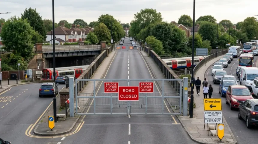
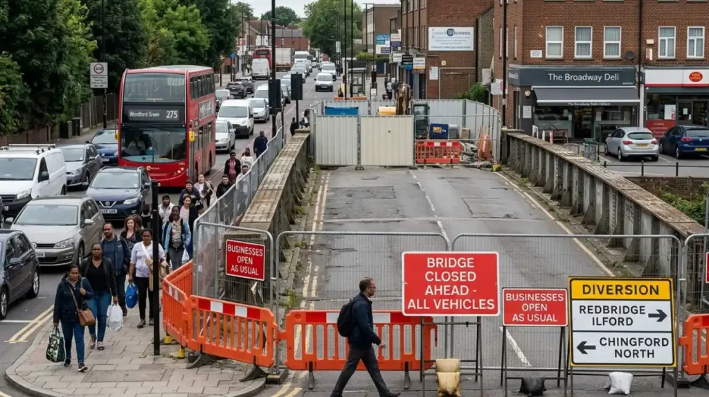
Broadmead Road Bridge closure in Woodford Green has caused sustained disruption across Redbridge since July 2023, with traffic diverted away from a key crossing over the Central line and local roads absorbing the extra flow. The closure affects about 15,000 vehicle journeys a day, and the most direct signed local diversion has been via Broadlands Avenue and Broadlands Crescent.
What is Broadmead Road Bridge?
Broadmead Road Bridge is a key road bridge in Woodford Green, Redbridge, carrying traffic over the Central line and connecting local routes in north-east London. It serves daily car, bus, and service journeys, so its closure has affected commuting, access, and neighbourhood traffic patterns since July 2023.
Broadmead Road Bridge is part of the local road network in the west of Redbridge, not a motorway or trunk road. Its role is practical rather than strategic, but that makes it important for everyday travel. When a local bridge like this closes, traffic does not disappear. It shifts onto residential streets, junctions, and nearby corridors that were never designed for that volume.
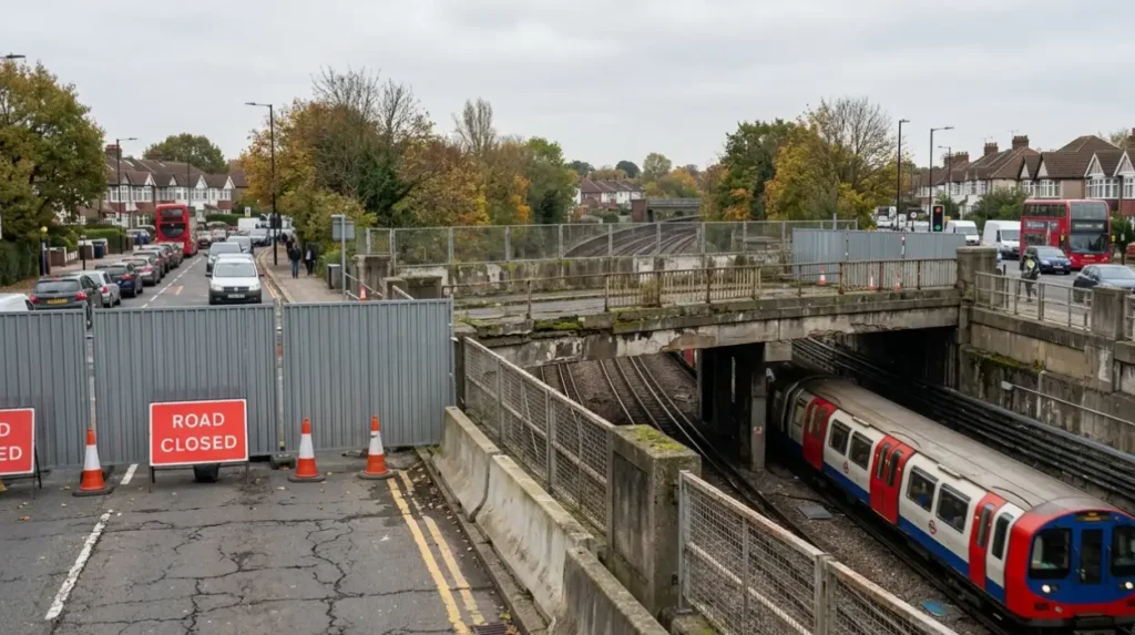
The bridge spans the Central line, which adds engineering and rail-safety complexity to any repair plan. Structural issues were found in the bridge, including cracks in the concrete and corrosion in internal metal reinforcement, which led to the closure to motor traffic. That means the problem is not just surface damage. It is tied to the bridge’s load-bearing structure and the need to keep passengers and road users safe.
Why was the bridge closed?
The bridge was closed after structural defects were identified, including cracks in the concrete and corrosion in the internal reinforcement, creating a safety risk for motor traffic. Closure began in July 2023 to prevent serious injury while investigations and repair planning continued.
The closure was not a routine maintenance measure. It followed the discovery of defects serious enough to require immediate action. According to reports, the road was shut as soon as the defects were identified, which is standard practice when a structure carrying vehicles over a live railway raises safety concerns. The bridge had been a four-lane route before closure, so losing it removed a substantial piece of local road capacity.
Maintenance responsibility sits with Redbridge Council, which has also sought central Government support for repair costs. The London Assembly has said the bridge has caused major disruption for residents and businesses, while Transport for London has supported bus diversions, signal retiming, and survey work. That shows the closure is a local engineering issue with wider transport consequences across east and north-east London.
How has the closure affected traffic?
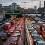
The closure has shifted about 15,000 daily vehicle movements onto alternative roads, increasing congestion, delaying journeys, and putting extra pressure on local streets and junctions across Woodford Green and nearby areas.
The biggest impact is delay. Broadmead Road was a direct route, and closing it forces drivers to reroute through roads that add both distance and time. The BBC reported that the diversion itself became difficult because another bridge on the route had been reduced to one lane due to a weakened footway. That means traffic congestion has not only moved, it has concentrated.
Local residents feel the effect in several ways. School runs take longer. Delivery vehicles spend more time in the area. Bus reliability suffers when road space becomes inconsistent. Businesses also face reduced footfall when customers avoid clogged routes or abandon trips altogether. The result is a chronic traffic problem rather than a short-term inconvenience.
This type of closure also changes driver behaviour. Some drivers stay on rat-runs through side streets. Others spread onto parallel roads, creating new bottlenecks. Over time, road noise, stop-start movement, and parking pressure increase on streets that were designed for lower volumes. That makes the closure a neighbourhood issue as much as a transport issue.
Which alternative routes are being used?
The main local diversion reported for Broadmead Road closure uses Broadlands Avenue and Broadlands Crescent in both directions, while wider trips also shift onto nearby roads such as Brady Road and Loughborough Lane.
The simplest alternative route identified in local reporting is Broadlands Avenue and Broadlands Crescent, used in both directions. That route suits short local trips, but it is still a residential corridor, not a high-capacity distributor road. When traffic volume rises, junction delay and queuing follow quickly.
A wider diversion context has also been discussed through Brady Road and Loughborough Lane. These are small roads, so they absorb only limited extra traffic before conditions worsen. The wider network also includes routes that connect toward Chigwell Road, Station Road, and surrounding east London corridors, depending on the destination. Drivers heading to different parts of Redbridge, Waltham Forest, and the Central line corridor use different combinations of local roads.
For clarity, the best route depends on the journey type:
- Local residential access often uses Broadlands Avenue and Broadlands Crescent.
- Longer cross-area trips spread into nearby connecting streets and main roads.
- Public transport and essential services rely on timetable adjustments and road-space management supported by TfL and Redbridge Council.
Alternative routes should be understood as a network response, not a single replacement road. The closure has no perfect substitute because Broadmead Road Bridge previously carried a heavy daily flow directly over the railway line.
What does this mean for residents?
Residents face longer journeys, more congestion on side streets, more noise, and more pressure on parking, safety, and local air quality because traffic has been redistributed through neighbourhood roads.
For residents, the closure is a daily quality-of-life issue. People living near diversion routes experience more passing traffic, especially at peak hours. Children walking to school, cyclists, and older residents all face a busier and less predictable street environment. Those effects are common when a major local link closes for a long period.
There is also a fairness issue. The burden of the closure does not fall evenly across the borough. Some streets absorb a disproportionate share of traffic, while other parts of Redbridge are less affected. That creates frustration when residents feel they are carrying the cost of a problem they did not create. It also makes traffic management harder because solutions in one place can push congestion somewhere else.
Another impact is time lost. Short journeys that used to take a few minutes now require planning. Visiting shops, reaching rail stations, and accessing health services can take longer. These changes sound small in isolation, but they accumulate across months and years. That is why the closure has remained a major local issue rather than a passing disruption.
What is the historical context?
The bridge has a long-running maintenance and safety history, with TfL reporting issues to Redbridge Council in 2014 and the closure later following a sequence of remedial works and ongoing structural concerns.
The current closure sits within a longer timeline. Transport for London first reported issues with Broadmead Road Bridge to Redbridge Council in 2014. That detail matters because it shows the problem was identified years before the 2023 closure. The bridge did not fail overnight. It moved through a long phase of monitoring, remedial action, and growing concern.
By the time the road closed in July 2023, the issue had become urgent. The closure was a protective measure, not an isolated event. It followed years of engineering concern, which is common with ageing bridge assets carrying both road traffic and rail infrastructure beneath. In dense urban areas, bridge maintenance often becomes a major policy issue because repair costs are high and responsibilities are split across organisations.
The repair challenge is also financial. Reports have placed the repair cost at at least £25 million, with no confirmed funding in place at the time of reporting. That figure explains why the closure has lasted so long. A structure over a live railway needs detailed design, safety planning, and capital funding before reopening can happen.
How are authorities responding?
Redbridge Council is responsible for the bridge, TfL has supported diversion and signal work, and central Government has been asked to help fund repairs, but a final solution remains tied to finance and engineering approval.
The response has involved several public bodies. Redbridge Council holds maintenance responsibility and has appealed for central Government help with the repair bill. TfL has supported the borough by helping with bus diversions, retiming traffic signals, and survey work. That kind of support helps reduce network pressure, but it does not solve the underlying structural problem.
The situation shows how urban bridge closures often depend on coordination between local government, transport operators, and national funding channels. Roads, rail, and planning rules intersect. When one bridge sits over a railway line, the repair programme must satisfy road safety standards and rail protection requirements at the same time. That slows delivery but reduces risk.
Public statements from London Assembly and parliamentary figures have kept pressure on the issue because the disruption is broad and visible. Residents and businesses have pushed for action because a long closure changes the economic geography of a place. The bridge is not just a structure. It is part of how the district works.
Why does this matter for East London?
Broadmead Road Bridge matters beyond Woodford Green because it affects commuting patterns, local business access, bus reliability, and cross-borough traffic flows across east and north-east London.
The closure has broader regional relevance because east London road networks are tightly connected. A single blocked route sends pressure into adjacent boroughs and onto connecting corridors. That can affect journey times for workers, shoppers, and visitors travelling across Redbridge and into nearby districts.
It also matters for local economic activity. Where access is harder, some people change habits. They travel less, arrive later, or choose different destinations. For high-street businesses, that can reduce trade. For public transport users, delays and road congestion can weaken confidence in buses and shared travel. That is why the bridge closure has become a test case for how east London handles long-duration infrastructure disruption.
There is a planning lesson too. London depends on ageing infrastructure, and repair decisions often become more expensive the longer they are delayed. Broadmead Road Bridge shows how a single structural problem can affect mobility, public finance, and neighbourhood life at the same time. That makes it a useful case study for readers following East London transport, council policy, and infrastructure news.
What happens next?
The next stage depends on securing funding, completing detailed repair plans, and carrying out engineering work that restores safe two-way traffic over the railway line. Until then, diversion routes and traffic management remain the practical reality.
The main question is not whether the bridge matters. It does. The question is when a funded repair programme can move from planning to construction. Until that happens, the closure remains in place and the diversion network carries the burden. The bridge has already been closed for a long period, and the reports available show no simple or immediate fix.
For local readers, the practical message is straightforward. Use alternative routes with extra travel time built in. Expect peak-hour congestion around the diversion network. Plan school runs, deliveries, and appointments with a margin for delay. The closure has become a permanent local travel factor, not a temporary roadworks note.
Broadmead Road Bridge is now one of the clearest examples of how a single infrastructure fault can reshape local movement in East London. Its impact stretches from daily commutes to community life, and its resolution depends on engineering, finance, and coordinated public action.
Why is Broadmead Road Bridge closed?
Broadmead Road Bridge was closed because engineers found serious structural defects, including cracks in the concrete and corrosion inside the bridge reinforcement. The closure started in July 2023 to prevent safety risks for drivers and the Central line running underneath.