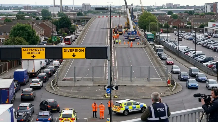
The Dagenham Flyover, known as the A13 Lodge Avenue Flyover, undergoes full closure for replacement from July 2026 to July 2028. This Transport for London project impacts 100,000 daily vehicles on the key East London route.
- What is the Dagenham Flyover?
- Where is the Dagenham Flyover located?
- Why is the Dagenham Flyover closing?
- When does the Dagenham Flyover closure start and end?
- What are the traffic impacts of the Dagenham Flyover closure?
- What are the official diversion routes during Dagenham Flyover closure?
- How will public transport change during the closure?
- What safety measures apply during construction?
- What is the historical context of the Dagenham Flyover?
- What are the economic and environmental implications?
- How does this fit into broader A13 improvements?
What is the Dagenham Flyover?
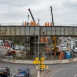
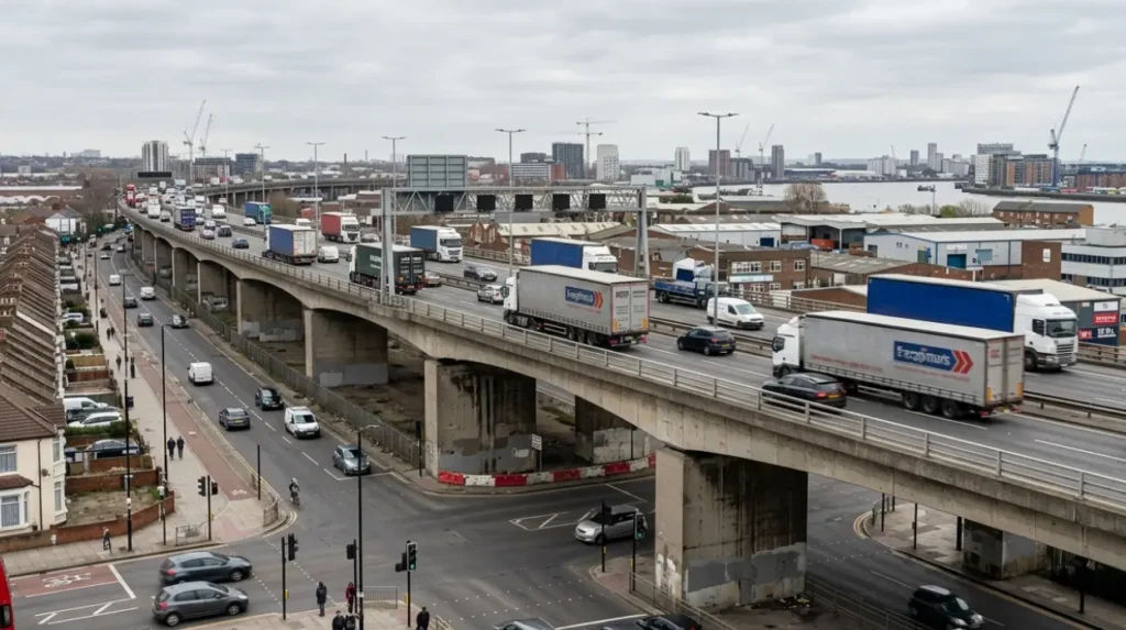
The Dagenham Flyover is the A13 Lodge Avenue Flyover, a 283-metre concrete bridge structure built in 1973 that carries eastbound A13 trunk road traffic over Lodge Avenue and local roads in Barking, London Borough of Barking and Dagenham.
The A13 trunk road links Central London to Essex through East London boroughs such as Newham and Barking and Dagenham. Lodge Avenue Flyover elevates two lanes of eastbound traffic above Lodge Avenue, a residential road connecting Barking town centre to industrial zones near the River Thames. Daily volumes exceed 100,000 vehicles, including 47 per cent freight from Essex ports to the City of London.
Routine inspections since 2010 identified concrete cracking, bearing corrosion, and fatigue from heavy loads. Bearings received replacement during three weekend closures in March and April 2023. The structure operates under the A13 Design-Build-Finance-Operate (DBFO) contract awarded to Road Management Services in 2000.
Replacement addresses 53 years of service under increased electric vehicle weights and de-icing salt exposure. The flyover spans from 283 metres northeast of Movers Lane junction to near Merrielands Crescent, at coordinates 51.535°N, 0.092°E.
Where is the Dagenham Flyover located?
The Dagenham Flyover locates on the A13 trunk road in Barking, London Borough of Barking and Dagenham, spanning Lodge Avenue between Ripple Road roundabout and Gascoigne Road, bordering residential areas and Creekmouth industrial zones.
Eastbound A13 traffic from Central London via East India Dock Road reaches the flyover after Gascoigne Road. Lodge Avenue underneath serves 50,000 local residents, linking north to Barking Power Station site and south to Thames-side factories. Proximity to Barking Riverside development heightens traffic demands.
Nearby landmarks include Eastbury Comprehensive School and Ripple Road Medical Centre. The site sits adjacent to A123 Ripple Road and A1153, forming full access junctions. Position between Barking town centre and Dagenham amplifies regional connectivity impacts.
Historical A13 evolution traces from Roman Watling Street, with 1970s flyovers responding to post-war housing growth. Current bottlenecks occur at Lodge Avenue and Renwick Road junctions.
Why is the Dagenham Flyover closing?
The Dagenham Flyover closes fully from July 2026 for two years to demolish and replace the 1973 structure due to irreversible structural deterioration, including corroded bearings, cracked concrete, and fatigue from 100,000 daily vehicles.
Inspections confirmed 30 per cent abutment corrosion accelerated by East London humidity and salts. 2023 bearing repairs proved temporary; full lifespan expired. Replacement costs £48 million but yields 50-year service under Eurocode standards.
Like-for-like design maintains two eastbound lanes while upgrading reinforcements. Economic analysis favours rebuild over repeated maintenance. Similar A13 River Lea Crossing received refurbishment in the 2020s using VolkerFitzpatrick methods.
TfL’s £2 billion road renewal programme prioritises such projects. Closure aligns with A13 DBFO lifecycle mandates since 2000.
When does the Dagenham Flyover closure start and end?
Site setup for Dagenham Flyover closure begins July 2026, with full construction and traffic diversions starting immediately after, completing the two-year replacement by July 2028.
Planning originated in 2014 TPS study, with Dragados UK refining designs since. Delays from 2025 stemmed from stakeholder consultations and assessments. Demolition occupies year one; new erection year two, including six-month defect testing.
TfL schedules avoid peak summer where possible. DBFO penalties deter overruns. Completion supports Thames River Crossings by 2030.
Precedents like 2023 closures caused minimal backups over weekends. Handover includes one-year monitoring.
What are the traffic impacts of the Dagenham Flyover closure?
Dagenham Flyover closure diverts 80,000-100,000 daily A13 eastbound vehicles to local roads and A406 North Circular from July 2026, adding 30 minutes to journeys and peaking at 45-minute delays off-peak.
Westbound A13 remains open. TfL models predict 20 per cent shift to public transport. Freight disruptions incur £5 million economic cost annually.
Peak-hour backups extend to quiet residential streets. 2023 bearing works previewed minor delays. Daily impacts affect Barking and Dagenham commuters, London-Essex freight, and 50,000 locals.
Mitigations include adaptive signals on Lodge Avenue and real-time apps. Historical Gallows Corner flyover replacement caused hour-long side-road queues.
What are the official diversion routes during Dagenham Flyover closure?
Eastbound diversions route A13 traffic via Lodge Avenue Junction off-slip, Porters Avenue, Wood Lane, Heathway, and Ripple Road; westbound via A1306 Ripple Road, Heathway, Hedgemans Road, Woodward Road, Lodge Avenue to A13 on-slip, indicated by signs from May 2026 to February 2027.
Alternative westbound HGVs follow A1306 Ripple Road, Heathway, Wood Lane, Longbridge Road, Lodge Avenue. Goresbrook interchanges use Choats Manor Way, Choats Road, Renwick Road, River Road.
New Goresbrook Road layouts debut in 2026. Local B-roads like Gascoigne Road absorb volume. Signage covers night works 10pm-6am Monday-Saturday.
Examples: Eastbound from Alfred’s Way links Lodge Avenue Junction circulatory system. TfL apps provide live updates.
How will public transport change during the closure?
TfL increases Elizabeth Line and District Line services by 10 per cent, adds bus priority on diversions, and expands Oyster contactless use targeting 20 per cent driver shift from Barking to Liverpool Street.
Elizabeth Line absorbs 15,000 daily drivers. Routes 100, 400, 460 divert via Victoria Road alternatives, skipping Massetts Road, Brighton Road, Povey Cross Road.
Cycle lanes widen on A406. Peak fares cap at £5. 2023 closures achieved 8 per cent mode shift. Apps integrate ETAs with diversions.
What safety measures apply during construction?
Safety deploys 24/7 traffic stewards, concrete barriers, variable message signs, 50mph limits, and night works 10pm-6am; workers use full harnesses under CDM 2015 regulations targeting zero incidents.
Public zones enforce 20mph on Lodge Avenue. Weekly audits track compliance. TfL averages 0.5 incidents per £10 million spend.
Examples: River Lea project recorded no lost-time injuries. Dust suppression and noise barriers protect residents.
What is the historical context of the Dagenham Flyover?
Dagenham Flyover built in 1973 as A13 upgrade amid post-war East London housing boom, handling initial 50,000 daily vehicles now doubled, evolving from Roman Watling Street via 1930s modernisations.
Ripple Road interchange followed in 1999. 1970s concrete piers now obsolete under heavier loads. Department of Transport oversaw pre-TfL construction.
Bearing inspections dated to 2009 A13/Lodge Avenue review. 2016 London Assembly confirmed no collapse risk pre-replacement.
What are the economic and environmental implications?
Closure costs £5 million in delays but generates 200 construction jobs, £20 million local spend, and £150 million long-term A13 reliability; new flyover uses 20 per cent recycled materials, cuts emissions 15 per cent post-2028.
Freight savings reach £10 million yearly. Barking GDP grows 2 per cent. Lifecycle carbon savings hit 10,000 tonnes.
Examples: A13 Riverside Tunnel (1.3km, opening 2026) unlocks 5,000 homes in Castle Green. EV reinforcements handle 40-tonne axles.

How does this fit into broader A13 improvements?
Dagenham Flyover replacement integrates £300 million TfL A13 DBFO programme, including River Lea refurbishment, Renwick Road junction, Movers Lane 2030, and 1.3km Riverside Tunnel mitigating Lodge Avenue bottlenecks.
A13 carries 150,000 vehicles daily; upgrades reduce congestion 12 per cent. DBFO since 2000 mandates replacements.
Sequence: Bearings 2023, flyover 2026-2028. Aligns Barking Riverside transit. Thames Gateway regeneration adds 28,300 homes.
What is the Dagenham Flyover?
The Dagenham Flyover is the elevated eastbound A13 Lodge Avenue Flyover in Barking and Dagenham. Built in 1973, it carries traffic over Lodge Avenue and nearby local roads as part of one of East London’s busiest transport corridors.