

Tower Hamlets occupies a distinctive stretch of East London where the River Thames connects medieval London, Victorian docks, historic riverside communities and the modern Docklands skyline. The borough’s southern boundary follows the Thames in a broad curve, creating a continuous setting for heritage attractions, walking routes, waterside architecture, public spaces and views across the river.
- What makes the Thames in Tower Hamlets important for visitors?
- What can visitors see at the Tower of London beside the Thames?
- Why should visitors explore Tower Bridge?
- What can visitors discover at St Katharine Docks?
- Where can visitors walk beside the Thames in Wapping?
- What is the Thames Path and how does it work around Tower Hamlets?
- What historic riverside features can visitors find in Wapping?
- What can visitors experience around Canary Wharf and the Isle of Dogs?
- How does the modern Docklands connect with the historic Thames?
- Where are the best places for Thames views in Tower Hamlets?
- How can visitors plan a Thames-focused day in Tower Hamlets?
- What should visitors know about safety and river conditions?
- Why is the Thames in Tower Hamlets important for the future of East London tourism?
For visitors, the Thames provides a clear way to understand Tower Hamlets geographically. The western riverside begins around the Tower of London and Tower Bridge. The route continues through St Katharine Docks and Wapping before reaching the regenerated Docklands around Canary Wharf and the Isle of Dogs. Each section presents a different stage in London’s relationship with the river.
The area combines internationally recognised landmarks with quieter riverside spaces. Tower Bridge provides Victorian engineering and elevated Thames views. St Katharine Docks provides a marina environment beside historic warehouses. Wapping retains Georgian riverside architecture and former dockland character. Canary Wharf presents modern commercial architecture, landscaped public spaces and an extensive collection of public art.
What makes the Thames in Tower Hamlets important for visitors?
The Thames in Tower Hamlets combines major heritage landmarks, historic docks, riverside walking routes, modern architecture, public art and distinctive views into one accessible East London destination for sightseeing, leisure, photography and cultural exploration.
The river is central to the borough’s identity. Tower Hamlets Council describes the Thames as forming the southern boundary of the borough and identifies the Tower of London and Tower Bridge as dominant features of its riverside panorama. The council also identifies Canary Wharf as a major European financial centre shaped by the regeneration of the historic Docklands.
This geographical concentration makes the riverside particularly useful for visitors with limited time. A single walking itinerary connects several different environments without requiring long journeys between attractions.
The western section is strongly associated with medieval and Victorian London. The eastern section demonstrates the transformation from working docks to offices, housing, restaurants, cultural spaces and public realm.
The Thames also provides a practical orientation point. Visitors can use the river as a continuous reference while moving between Tower Hill, Wapping, Shadwell and the Isle of Dogs.
What can visitors see at the Tower of London beside the Thames?
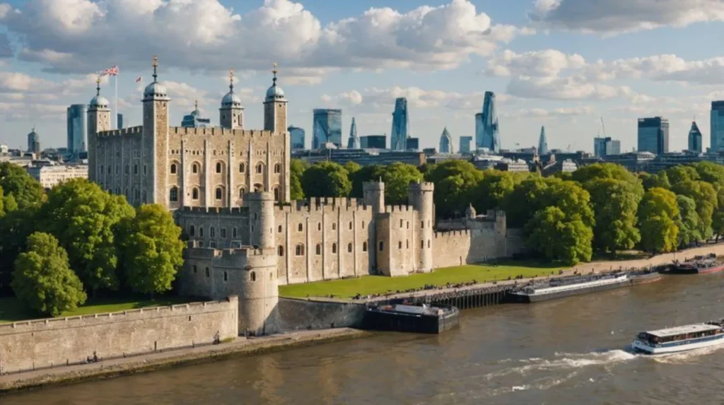
The Tower of London is a UNESCO World Heritage Site centred on the White Tower, an 11th-century Norman fortress established by William the Conqueror and strategically positioned beside the Thames as a defensive gateway to London.
The Tower of London is one of the most significant historic sites on the Tower Hamlets riverside. UNESCO inscribed it as a World Heritage Site in 1988 under criteria relating to cultural influence and architectural significance. The property covers 7.5 hectares.
The White Tower forms the core of the complex. William the Conqueror established the fortress after the Norman Conquest, and the site developed through successive royal building programmes. Henry III and Edward I expanded the fortress during the 13th and early 14th centuries.
The Tower had several functions across its history. It operated as a fortress, royal palace, prison, armoury and repository for important state materials. Its relationship with the river was fundamental because the Thames provided a transport route and helped establish the Tower as a gateway to London.
The river entrance known as Traitors’ Gate is particularly relevant to the riverside setting. The water entrance allowed prisoners and other important arrivals to enter the fortress directly from the Thames.
As you explore the modern riverside, you are crossing land with a deep heritage. Read about the full to understand its origins.
UNESCO identifies the Tower’s position at a bend in the Thames as an important part of its significance. Its location connected royal authority, defence and control of access to the capital.
Visitors should therefore view the Tower from both land and river perspectives. The riverside reveals why the location was strategically important rather than treating the fortress as an isolated monument.
Why should visitors explore Tower Bridge?
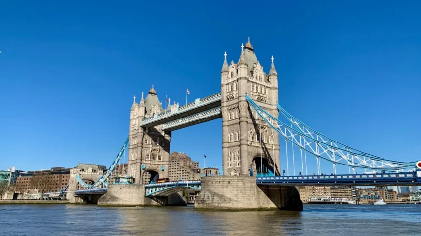
Tower Bridge is a working Victorian bascule and suspension bridge opened in 1894, offering riverside views, high-level walkways, glass floors and access to historic Victorian engine rooms that explain its engineering purpose.
Tower Bridge is one of London’s defining landmarks and forms a major visual gateway into the Pool of London. It opened on 30 June 1894 and was designed to maintain road traffic while allowing tall vessels to reach the docks further upstream.
The bridge has two distinctive towers connected by high-level walkways. Visitors entering the attraction can see these walkways from 42 metres above the River Thames. The experience also includes glass floors that provide a direct view towards the river and road below.
The Victorian Engine Rooms explain the original mechanism used to operate the bridge. The bridge lifts were historically powered by steam engines before later systems replaced the original machinery.
Tower Bridge remains operational as a road crossing. Its bascules continue to lift for river traffic. This makes the bridge both a heritage attraction and an active piece of London infrastructure.
The bridge is also an important photography location. Views towards the Tower of London, the City skyline and the Thames create strong visual connections between medieval, Victorian and modern London.
Visitors interested in engineering should allow additional time for the internal exhibition. Those focused on sightseeing can experience the surrounding riverside without entering the attraction.
What can visitors discover at St Katharine Docks?
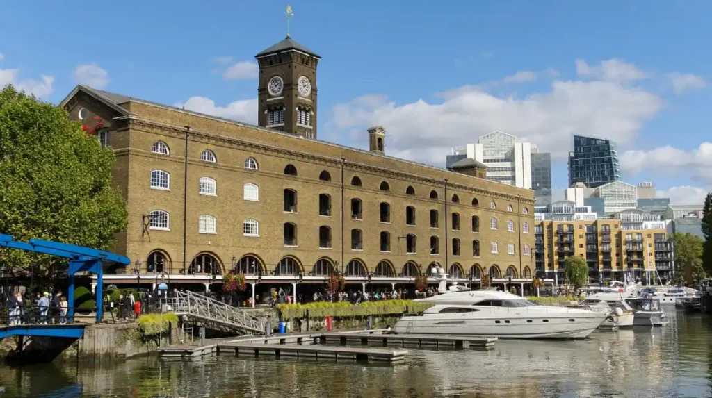
St Katharine Docks is a historic marina beside Tower Bridge created in the 19th century and now used for waterside leisure, dining, walking and sightseeing around preserved dock structures and modern waterfront development.
St Katharine Docks provides a quieter environment immediately east of the Tower of London and Tower Bridge. The dock complex opened in 1828 after a major redevelopment scheme associated with engineer Thomas Telford.
The construction transformed the area substantially. Around 1,250 houses were demolished alongside the medieval Hospital of St Katharine to create the dock basins. The resulting docks were designed for commercial activity but struggled to accommodate larger ships.
The docks experienced decline after the Second World War and closed in 1968. They were subsequently regenerated as a marina and visitor destination.
Historic buildings remain part of the character of the site. Ivory House is identified by Tower Hamlets as the surviving historic warehouse on the site and retains elements of the original warehouse character.
The Dickens Inn is another recognisable building. It was constructed between 1793 and 1799 as a spice warehouse and now operates as a hospitality venue.
For visitors, the attraction lies in the contrast between the enclosed dock basins and the open Thames nearby. The area works well as a stop between Tower Bridge and Wapping.
Where can visitors walk beside the Thames in Wapping?
Wapping offers one of the strongest historic riverside walking experiences in Tower Hamlets, combining the Thames Path with former warehouses, Georgian houses, old stairs, memorial gardens, dock basins and views towards central London.
Wapping provides a direct connection between the river’s industrial past and its modern public walking network. The Thames Path passes through several historically important sites before connecting with Wapping High Street and surrounding dock areas.
Wapping Pierhead contains two facing terraces of Georgian houses originally associated with dock officials. Wapping Old Stairs provides another direct connection with the river and represents the historic pattern of riverside access.
The Hermitage Riverside Memorial Garden provides a landscaped section beside the Thames. It includes Wendy Taylor’s memorial sculpture commemorating East London civilians who died during the Second World War.
Another Wendy Taylor sculpture, Voyager, stands along the route. Its form references a ship’s propeller and reinforces the maritime character of the area.
The Wapping section demonstrates why the Thames Path is more than a recreational trail. It links public access with industrial archaeology, architecture, memorials and former working waterfronts.
The route also provides opportunities to observe the changing river environment. Tidal conditions influence the Thames foreshore, so visitors should remain within safe public areas and follow local signs.
What is the Thames Path and how does it work around Tower Hamlets?
The Thames Path is a long-distance riverside walking route following the River Thames, with the London section connecting major landmarks, historic waterfronts and public spaces through a continuous network of signed paths and local routes.
The Thames Path extends for approximately 180 miles from the Thames Barrier area through London towards the river’s source in Gloucestershire. The route officially opened in 1996 after the creation of 16 miles of new riverside path and three bridges.
The Tower Hamlets section forms part of the wider London riverside network. The route between the Thames Barrier and Tower Bridge is approximately 9 miles, or 14.5 kilometres, while the Tower Bridge-to-Putney section continues for approximately 10 miles, or 16 kilometres.
Visitors do not need to complete a full section in one outing. Short walks provide access to specific attractions. A visitor can concentrate on Tower Bridge and St Katharine Docks, continue through Wapping, or extend the route towards the Isle of Dogs.
Walking conditions vary according to the location. Some sections run directly beside the river, while others pass through streets, dock areas or developed waterfronts.
The Thames Path also provides a useful structure for digital nomads and business travellers. Short riverside walks can fit around meetings because Tower Hill, Wapping and Canary Wharf have strong public transport connections.
What historic riverside features can visitors find in Wapping?
Wapping contains surviving evidence of London’s former maritime economy, including dockside buildings, Georgian residences, historic river stairs, former warehouse areas, memorial landscapes and connections between the Thames and inland dock infrastructure.
Wapping developed around the needs of London’s docks and river traffic. Its historic buildings reflect the importance of maritime employment and administration.
Wapping Pierhead is particularly significant because its Georgian terraces were built for dock officials. Their location close to the river demonstrates the relationship between residential architecture and the former commercial waterfront.
Wapping Old Stairs is another important feature. Historic stairs connected the built-up riverside with the foreshore and landing points. These structures demonstrate how people accessed the Thames before modern pedestrian infrastructure.
The route also connects with the Wapping Wood Canal and Hermitage Basin. The canal network formed part of the wider system linking dock facilities with the river.
Tower Hamlets’ own riverside walking guide identifies these features as part of a route connecting Wapping with St Katharine Docks.
For heritage-focused visitors, this area provides a concentrated introduction to the physical geography of London’s former port.
What can visitors experience around Canary Wharf and the Isle of Dogs?
Canary Wharf presents the modern side of the Tower Hamlets riverside, combining high-rise commercial architecture, landscaped public spaces, dock basins, restaurants, transport connections and an extensive collection of permanent public artworks.
Canary Wharf developed from the historic Docklands into one of London’s major financial districts. Tower Hamlets describes the area as an internationally recognised Docklands centre and a major European financial hub.
The skyline is dominated by high-rise commercial buildings, creating a strong contrast with the lower historic architecture around Wapping and Tower Hill.
Visitors can also explore public art throughout the estate. Canary Wharf Group’s public art programme contains more than 100 permanent works, including sculptures, murals, architectural installations and light-based works.
The collection includes works such as Ocean Rise by Aphra Shemza, Captivated by Colour by Camille Walala and Skystation by Peter Newman.
This makes Canary Wharf useful for visitors who want a riverside experience that extends beyond historic attractions. Public art provides another layer of interpretation across the modern waterfront.
The docks also preserve the geographical structure of the former port. Water remains central to the district even though its economic function has changed from cargo handling to finance, retail, hospitality, offices and residential development.
How does the modern Docklands connect with the historic Thames?
Modern Docklands represents a major transformation in the Thames waterfront, changing former commercial dock areas into a mixed urban district while retaining water basins, historic buildings, public spaces and visual connections with the river’s maritime past.
The history of Tower Hamlets is closely linked to the port of London. The Museum of London Docklands documents this transformation from a major port environment to the regenerated Docklands seen today. Tower Hamlets Council identifies the museum as an important resource for understanding this history.
The change was driven by the decline of traditional docks and the relocation of cargo handling to larger facilities downstream. Former docklands then became available for redevelopment.
Canary Wharf is the most visible result of this transformation. The district retains water-based geography but now supports financial services, offices, retail, leisure and public art.
This contrast is one of the defining characteristics of the Tower Hamlets Thames. Visitors can move from a Norman fortress to a Victorian bridge, a 19th-century dock, Georgian riverside houses and a contemporary financial skyline within a relatively compact area.
The waterfront therefore functions as a chronological journey through London’s urban development.
Where are the best places for Thames views in Tower Hamlets?
The strongest Thames views in Tower Hamlets come from Tower Bridge, the Tower of London riverside, Wapping, St Katharine Docks and the wider Docklands waterfront, where historic structures and modern London skylines appear together.
Tower Bridge provides elevated views from its high-level walkways at approximately 42 metres above the river. These views cover substantial parts of central and eastern London.
The riverside around the Tower of London offers a lower-level perspective. Here, the relationship between the fortress, Tower Bridge and the river is especially clear.
St Katharine Docks provides a different visual environment. The enclosed basins, yachts, warehouses and surrounding buildings create a marina setting close to the Thames.
Wapping offers longer and quieter river views. The route around Wapping Pierhead and the riverside gardens presents historic buildings alongside the tidal river.
Canary Wharf provides the strongest modern skyline. High-rise towers surround dock basins and public spaces, creating views that demonstrate the scale of Docklands redevelopment.
The best viewpoint therefore depends on the visitor’s purpose. Heritage visitors should prioritise Tower Bridge and the Tower of London. Architecture-focused visitors should include Canary Wharf. Walkers should explore Wapping.
How can visitors plan a Thames-focused day in Tower Hamlets?
A Thames-focused day works best when visitors follow the river from Tower Hill through Tower Bridge and St Katharine Docks, continue into Wapping and finish around Canary Wharf or the Isle of Dogs.
Start at Tower Hill, where the Tower of London and Tower Bridge provide immediate access to two major landmarks. Allow dedicated time for the Tower of London if the priority is medieval history.
Continue towards Tower Bridge. Visitors entering the bridge can explore the high-level walkways and Victorian Engine Rooms. The bridge also provides a useful transition between the historic western riverside and the dockland areas further east.
Continue through St Katharine Docks for a marina environment and preserved dock architecture. The route then leads towards Wapping.
In Wapping, follow the Thames Path and explore Wapping Pierhead, Wapping Old Stairs and Hermitage Riverside Memorial Garden. The Tower Hamlets walking route specifically connects these riverside features with St Katharine Docks and nearby dock infrastructure.
Finish around Canary Wharf if time permits. The modern skyline, dock basins, public art and landscaped areas provide a strong contrast with the historic riverside visited earlier.
Public transport makes the itinerary adaptable. Tower Hill provides Underground access, while Canary Wharf is served by major rail and Underground connections.
Explore More Area Guide
Top Leisure Destinations in Tower Hamlets, East London 2026
Tower Hamlets Attractions for First-Time Visitors 2026
What should visitors know about safety and river conditions?
Visitors should treat the Thames as a tidal working river, remain on designated public paths, observe barriers and warning signs, keep away from unstable foreshore areas and check route conditions before longer riverside walks.
The Thames is an active waterway rather than a static recreational lake. Tides change the appearance and accessibility of the foreshore, while river traffic continues throughout London.
The Thames Path guidance highlights the dangers associated with cold water, strong currents, tidal conditions and mud. It also warns that people can become cut off by changing tides.
Visitors should therefore avoid entering the river or walking onto exposed foreshore areas unless they are following an authorised activity with appropriate safety arrangements.
Long-distance walkers should also check for temporary diversions. The wider Thames Path network experiences occasional closures and diversions caused by construction and infrastructure works. Current route information is particularly important for visitors planning extended walks beyond the core Tower Hamlets attractions.
For ordinary sightseeing, the established riverside paths and public spaces provide the appropriate environment. Comfortable footwear is useful for longer walks because the itinerary combines paved streets, riverside paths and historic dock areas.
Why is the Thames in Tower Hamlets important for the future of East London tourism?
The Thames in Tower Hamlets will remain important to East London tourism because heritage conservation, public riverside access, Docklands regeneration, cultural programming and modern commercial development continue to concentrate major visitor experiences around the waterfront.
The borough’s riverside already demonstrates several phases of London’s development. The Tower of London represents Norman and medieval royal power. Tower Bridge represents Victorian engineering. St Katharine Docks represents nineteenth-century commercial infrastructure. Wapping preserves the character of a historic dockside community. Canary Wharf represents modern Docklands regeneration.
UNESCO also identifies the relationship between the Tower of London and its wider setting as an important conservation consideration. Views into, out of and across the World Heritage Site remain significant because new development can affect the perception of the Tower and its relationship with the Thames.
This makes the river a continuing planning and heritage asset rather than simply a scenic feature.
For tourists, the result is a destination with substantial depth. A short visit can focus on landmark attractions. A longer visit can include walking, architecture, museums, public art, historic docks and modern commercial districts.
The Thames therefore provides one of the clearest ways to explore the changing identity of Tower Hamlets. Its riverside connects the borough’s historic foundations with its contemporary role as a major East London destination.
What are the best things to explore around the Thames in Tower Hamlets?
The best riverside attractions include the Tower of London, Tower Bridge, St Katharine Docks, Wapping, the Thames Path, Canary Wharf and the Isle of Dogs. Together, they cover history, architecture, walking, views, public art and leisure.