
Limehouse is a historic riverside neighbourhood in the London Borough of Tower Hamlets, East London. It is known for its maritime heritage, Georgian architecture, historic pubs, canal connections and walking routes beside the River Thames. The neighbourhood combines surviving industrial landmarks with modern residential developments, making it a rewarding destination for visitors interested in London’s docklands history and waterside attractions.
- What Is Limehouse Known for in Tower Hamlets?
- How Did Limehouse Develop from a Maritime Settlement into a Modern Neighbourhood?
- Which Historic Streets and Buildings Should Visitors Explore in Limehouse?
- Narrow Street and its riverside architecture
- The Grapes and Limehouse’s historic pubs
- St Anne’s Church
- Historic industrial features
- What Can Visitors See at Limehouse Basin?
- Where Can Visitors Enjoy Riverside Walks Around Limehouse?
- What Other Attractions and Green Spaces Are Near Limehouse?
- How Can Visitors Reach Limehouse and Get Around the Area?
- Is Limehouse suitable for a walking itinerary?
- Is parking available near Limehouse Basin?
- What should visitors know about accessibility?
- When Is the Best Time to Explore Limehouse?
- How Can Visitors Plan a Half-Day Itinerary in Limehouse?
- Why Does Limehouse Remain Important to East London’s Heritage?
Limehouse sits between the City of London and the Isle of Dogs, close to Canary Wharf. Its streets reveal the development of London’s commercial waterfront, while Limehouse Basin connects the Regent’s Canal with the Thames. Visitors can explore historic Narrow Street, admire St Anne’s Church, walk beside moored boats and discover how canals and docks shaped the East End.
The area is accessible by Docklands Light Railway (DLR), making it suitable for a half-day visit, a longer East London walking itinerary or a short excursion between business appointments. Its combination of architecture, waterways, public spaces and historic landmarks offers a clear introduction to the changing identity of Tower Hamlets.
What Is Limehouse Known for in Tower Hamlets?
Limehouse is known for its maritime history, historic streets, Limehouse Basin, riverside walks and distinctive architecture in Tower Hamlets. Its waterfront developed around shipping and canal transport, while surviving landmarks and regenerated docklands now attract walkers, architecture enthusiasts and visitors exploring East London’s industrial past.
Limehouse developed beside the River Thames as a centre of maritime commerce. Its location gave merchants, boatbuilders, ropemakers and dock workers direct access to London’s shipping network. The neighbourhood’s historic identity remains visible in its street names, riverside buildings, canal infrastructure and surviving public landmarks.
The name Limehouse is associated with lime kilns used to produce quicklime, a material employed in building mortar. Historic England records the settlement’s name in 1367 as le Lymostes, with lime kilns documented at Limekiln Dock by 1363. These early industrial activities established the foundations of the area’s commercial character.
Limehouse later became an important interchange between maritime shipping and inland waterways. Barges transported goods from the Thames into Britain’s canal network, connecting London with industrial and commercial centres farther inland.
Today, the neighbourhood offers several distinct experiences. Narrow Street provides a sense of its historic riverside setting, Limehouse Basin presents its canal heritage, and St Anne’s Church introduces visitors to its architectural and religious history. Nearby Canary Wharf adds a modern commercial skyline to the landscape.
Limehouse is particularly suitable for independent exploration because its main attractions are connected by walkable streets and waterside paths. Visitors can combine architectural sightseeing with photography, a canal-side stroll or a longer walk towards Wapping and Canary Wharf.
How Did Limehouse Develop from a Maritime Settlement into a Modern Neighbourhood?
Limehouse developed from a medieval riverside settlement into a busy maritime and industrial district, supported by shipping, rope-making, pottery and canal transport. Following wartime destruction and the decline of commercial docks, redevelopment transformed parts of the waterfront into residential, leisure and marina spaces.
Limehouse’s history reflects the wider economic development of London’s East End. Its proximity to the Thames supported river-based industries long before the arrival of modern transport systems.
During the medieval period, the settlement grew along the river, where commerce centred on maritime activity. The foreshore between Narrow Street and the Thames was reclaimed during the late sixteenth century, and wharves appeared during the late sixteenth and early seventeenth centuries. Archaeological investigations have identified evidence of historic waterfront structures and industrial activity.
The neighbourhood developed additional industries in the eighteenth century. A porcelain factory on Narrow Street operated during the 1740s and produced wares associated with early English porcelain manufacturing. Ropemaking also supported the maritime economy, supplying ships with ropes for rigging, anchors and other essential equipment.
The opening of the Regent’s Canal Dock in 1820 marked another major stage in Limehouse’s development. The dock, now known as Limehouse Basin, allowed cargo to transfer between seagoing vessels and inland canal boats. Goods such as coal and timber moved through this transport network, linking London’s waterfront with markets across Britain.
The nineteenth century also brought social and cultural change. Limehouse became associated with one of London’s early Chinese communities, particularly around Limehouse Causeway, Pennyfields and West India Dock Road. This history forms part of the broader story of migration, trade and changing communities in the East End.
The Second World War caused substantial damage to parts of Limehouse. Subsequent changes to transport, industry and dock operations altered the neighbourhood’s historic street pattern. Commercial dock activity declined during the twentieth century, and the closure of the basin to commercial traffic in 1969 marked the end of its original role as a major cargo interchange.
Later regeneration introduced new housing, improved public spaces and leisure facilities. The basin became a marina, while the wider Docklands area developed new commercial and residential districts. Modern Limehouse therefore retains traces of its maritime past within a neighbourhood shaped by changing economic uses.
To explore this transformation in greater depth, connect this visitor guide with the full Limehouse Maritime History and Industrial Heritage Guide. This is the single historical-background anchor for readers who want a more detailed account of the area’s origins and development.
Which Historic Streets and Buildings Should Visitors Explore in Limehouse?
Limehouse’s historic streets and buildings reveal its maritime character through Georgian houses, old warehouses, riverside pubs and landmark churches. Narrow Street, St Anne’s Church and the surviving dock infrastructure provide visitors with accessible places to examine the neighbourhood’s architecture, social history and relationship with the River Thames.
Narrow Street and its riverside architecture
Narrow Street is one of the most recognisable historic streets in Limehouse. It runs close to the River Thames and preserves the area’s connection with waterfront commerce, traditional buildings and riverside public houses.
Walking along Narrow Street reveals a mixture of older brick buildings and later residential developments. The street’s setting illustrates how Limehouse evolved from a working waterfront into a residential neighbourhood while retaining elements of its historic identity.
Visitors should look for changes in building height, brickwork, entrances and the relationship between the street and the river. These features help explain the area’s gradual development rather than presenting it as a uniform historic district.
The Grapes and Limehouse’s historic pubs
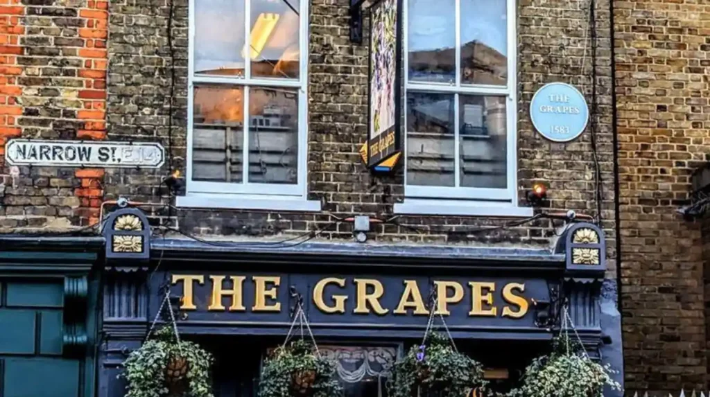
The Grapes is a well-known riverside pub at 76 Narrow Street. Its location reflects the longstanding relationship between public houses and the working communities of London’s waterfront.
Historic pubs served dock workers, sailors, merchants and local residents. They also functioned as social meeting places in neighbourhoods shaped by irregular working hours and maritime trade.
The Grapes remains a prominent point of interest for visitors walking along Narrow Street. Anyone planning to eat or drink there should check current opening hours, menu information and access arrangements before visiting.
St Anne’s Church
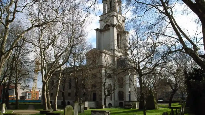
St Anne’s Church stands on Commercial Road and is one of Limehouse’s most significant architectural landmarks. Designed by Nicholas Hawksmoor, an English architect known for his monumental churches, it was built between 1714 and 1724 and consecrated in 1730.
The church was constructed to serve the growing parish of Limehouse. Its prominent tower and distinctive architectural form distinguish it from the surrounding streetscape. Its maritime associations are also notable: the church’s elevated position and historic features connected it with navigation on the Thames.
The adjacent churchyard became a public garden in 1887 after its use for burials ended. This space offers visitors a quieter place to appreciate the building and its surroundings. The church’s exterior is a useful starting point for understanding Limehouse’s eighteenth-century religious and civic development.
Historic industrial features
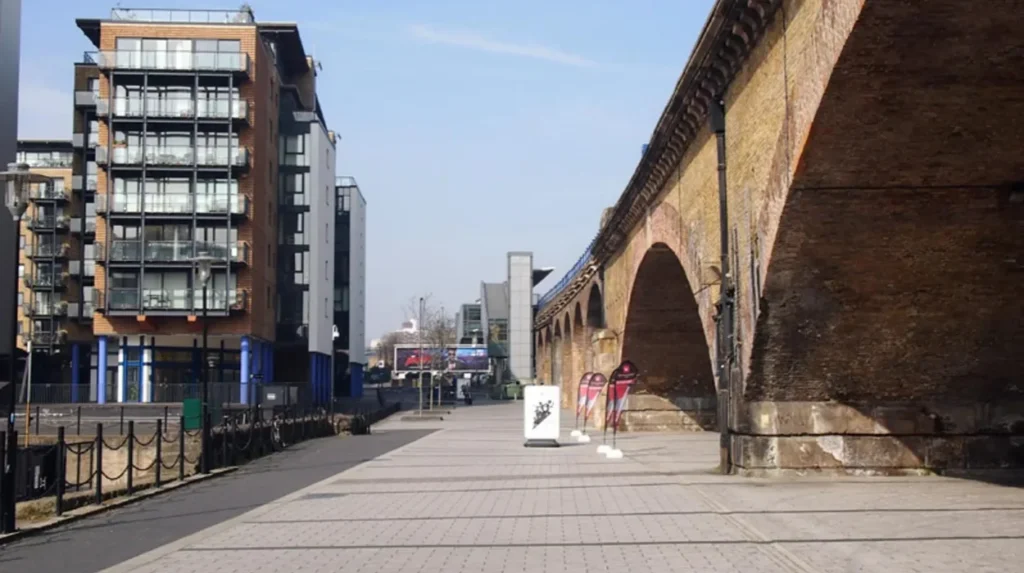
Limehouse’s maritime history survives in more than traditional houses and pubs. Old wharf locations, canal structures, railway infrastructure and remnants of dock engineering reveal how goods moved through the neighbourhood.
Some industrial features are incorporated into the modern built environment. The Docklands Light Railway follows sections of historic railway infrastructure, while the basin retains locks and bridges associated with waterborne transport.
Observing these details helps visitors recognise that Limehouse’s heritage includes practical engineering as well as architecture. The area’s historic character is best understood through the relationship between its streets, waterways, industrial sites and public buildings.
What Can Visitors See at Limehouse Basin?
Limehouse Basin is a marina and historic canal dock linking the Regent’s Canal with the River Thames. Visitors can watch boats, explore waterside paths, observe lock infrastructure and view the surrounding Docklands skyline while learning how nineteenth-century canal transport supported London’s commercial economy.
Limehouse Basin is one of the area’s defining attractions. Originally known as Regent’s Canal Dock, it opened in 1820 as a transfer point between seagoing ships and inland canal boats. Its location connected the Thames with the Regent’s Canal and the wider British inland waterway network.
The basin’s historic role was straightforward. Larger ships delivered cargo to the dock, where goods were transferred to smaller boats that could navigate inland canals. Coal, timber and other commodities travelled through this network to serve London’s businesses and communities elsewhere in Britain.
The scale of its former operations is reflected in historical figures cited by the Canal & River Trust. In 1865, records show that 1,500 ships and 15,336 barges entered the dock. These figures demonstrate the importance of the basin during the peak period of commercial canal traffic.
What should visitors look for at the basin?
The marina now accommodates narrowboats, yachts and visiting pleasure craft. Walking around the water provides clear views of the boats, bridges and surrounding buildings.
The entrance swing bridge is another notable feature. It opens to allow suitable vessels to pass between the Thames and the basin. Traffic signals and barriers control movement when the bridge operates, demonstrating that the waterway remains a functioning navigation route.
The Accumulator Tower is a particularly important industrial landmark. Built in 1869, it helped maintain hydraulic pressure for machinery used to operate cranes, locks and swing bridges. The structure represents an earlier phase of industrial engineering, when pressurised water powered equipment across the dock.
Visitors should also look for the changing skyline beyond the marina. Modern buildings in the Canary Wharf district contrast with the historic dock infrastructure, making the basin an effective location for photography and architectural observation.
How much does it cost to visit?
Access to Limehouse Basin for a walk is free, according to the Canal & River Trust. The public-facing waterside environment makes it suitable for visitors planning a low-cost day out.
The basin itself is primarily an outdoor attraction. Costs arise from optional activities, refreshments or purchases at nearby businesses rather than general access to the water’s edge. Facilities such as toilets are limited, so visitors should plan accordingly.
The marina is an operational waterway, not a public swimming area. Visitors should respect mooring areas, obey signs and keep clear of working locks and moving vessels.
Where Can Visitors Enjoy Riverside Walks Around Limehouse?
Visitors can follow waterside routes around Limehouse Basin, along the Thames Path and beside Limehouse Cut. These walks combine canal infrastructure, historic streets, boats and modern Docklands views, offering options for short circular outings and longer journeys towards neighbouring East London districts.
Walking is one of the easiest ways to explore Limehouse because several attractions are close to the waterways. Routes connect the marina with Narrow Street, nearby green spaces and longer pedestrian paths along the Thames and canals.
The Limehouse Basin circular walk
The Canal & River Trust publishes a circular route around Limehouse Basin measuring approximately 1 mile (1.6 kilometres). The route starts and finishes near Limehouse DLR station and passes the marina, canal infrastructure and historic features.
This short walk suits visitors with limited time. It offers an introduction to the neighbourhood without requiring a full-day itinerary. Allow extra time for photography, observing boats and exploring nearby streets.
The route includes pedestrian bridges and paths around the basin. Surfaces and access arrangements vary, so visitors requiring step-free access should check the current route information before setting out.
Walking beside the River Thames
The Thames Path is a long-distance walking route following the river through London and beyond. In Limehouse, the riverfront offers views of passing vessels, historic buildings and the evolving Docklands skyline.
The riverside environment changes with the tide and weather. Visitors can observe commercial vessels and leisure craft while gaining a sense of how the Thames continues to function as a working river.
Walkers should remain on designated paths and observe riverside safety signs. River edges, steps and surfaces become slippery in wet weather. The Thames is tidal, so it is important to avoid climbing down onto exposed foreshore areas without checking safety information.
Exploring Limehouse Cut
Limehouse Cut is an important part of London’s canal history. Authorised by the River Lee Act 1766, it created a more direct navigable connection between the River Lea system and the Thames, reducing the need for barges to navigate a longer tidal route around the Isle of Dogs.
The canal’s towpath provides a different experience from the open riverside. Visitors encounter narrower waterways, bridges, residential streets and industrial remnants. The route is useful for walkers interested in engineering, urban geography and the relationship between canals and London’s historic economy.
The Canal & River Trust identifies a route of approximately 2 miles (3.2 kilometres) along Limehouse Cut towards Queen Elizabeth Olympic Park, although the exact distance depends on the selected starting and finishing points.
For longer walks, check the latest towpath conditions and route guidance. Canal paths are shared environments in which walkers and cyclists need to leave space for each other.
What Other Attractions and Green Spaces Are Near Limehouse?
Limehouse’s surrounding attractions include local gardens, Ropemakers Fields, Canary Wharf and the Museum of London Docklands. These places extend a visit beyond the historic waterfront, combining outdoor recreation, architectural sightseeing and exhibitions that explain the commercial, social and maritime development of London’s Docklands.
Ropemakers Fields
Ropemakers Fields is a public green space near Limehouse Basin. Its name recalls the area’s historic ropemaking industry, which supplied ropes and rigging for ships and other maritime uses.
The park provides an open space close to the canal and residential streets. It is suitable for a short break during a walking itinerary, particularly for visitors exploring the basin and Narrow Street.
The surrounding area also illustrates how former industrial land has been adapted for modern urban use. Visitors can combine a walk through the park with views of nearby waterways and the infrastructure associated with Limehouse’s maritime past.
St Anne’s Churchyard Gardens
The gardens beside St Anne’s Church provide a small public green space within the historic neighbourhood. The former burial ground became public gardens in 1887, preserving an open setting around Hawksmoor’s church.
The gardens are useful for visitors interested in historic landscapes and urban heritage. Their location also makes them a convenient stop when walking between Commercial Road, the church and Limehouse Basin.
Museum of London Docklands
The Museum of London Docklands, located at West India Quay, explores the history of the River Thames, the Port of London and the communities shaped by maritime commerce.
Its exhibitions provide context for understanding the wider economic system in which Limehouse developed. Visitors can learn about cargo handling, dock labour, migration and the transformation of London’s waterfront.
The museum is particularly useful for travellers who want more historical context than a street walk provides. Check the museum’s official website for current exhibitions, opening hours, admission arrangements and accessibility information before travelling.
Canary Wharf
Canary Wharf is a modern commercial district close to Limehouse. Its office towers, public spaces, shops and waterside paths illustrate the transformation of the former Docklands into a major business centre.
The contrast between Limehouse’s older streets and Canary Wharf’s contemporary skyline is one of the area’s most distinctive geographical features. Visitors can combine a historic walk with modern architecture, cafés and shopping.
Canary Wharf also suits business travellers staying in the district who want to explore nearby heritage during a break from meetings. The DLR connects the two areas, while pedestrian routes provide additional options for exploring the wider waterfront.
How Can Visitors Reach Limehouse and Get Around the Area?
Limehouse is accessible by Docklands Light Railway, with Limehouse station serving the neighbourhood and providing connections across East London. Visitors can explore the main attractions on foot, combine walking with public transport, and check live travel information before starting their journey.
Limehouse station is the most convenient public transport starting point for many visitors. The station is served by the Docklands Light Railway, which connects the neighbourhood with Canary Wharf, the City of London and other destinations across the Docklands network.
The station is close to Limehouse Basin, making it a practical starting point for a short circular walk. From there, visitors can continue towards Narrow Street, the Thames waterfront and nearby green spaces.
Is Limehouse suitable for a walking itinerary?
Yes. The basin, historic streets and church can be combined into a compact itinerary, while the Thames Path and Limehouse Cut offer options for longer walks.
A practical route starts at Limehouse station, continues around the basin, follows nearby streets towards Narrow Street and The Grapes, and then returns through the neighbourhood. Visitors with additional time can explore St Anne’s Church or extend the walk along the canal.
Allow additional time for stops and route changes. Canal bridges, traffic crossings and the precise entrances to waterside paths affect the time needed to move between locations.
Is parking available near Limehouse Basin?
Parking is limited around Limehouse Basin, and the Canal & River Trust advises that there is no parking at the basin itself. Public transport is therefore a practical option for visitors arriving from elsewhere in London.
Drivers should check local parking restrictions, controlled parking zones and current charges before travelling. Parking rules differ between public roads and private facilities, and spaces near the waterfront are not guaranteed.
What should visitors know about accessibility?
Accessibility varies between Limehouse’s historic streets, canal towpaths and modern developments. Some paths include steps, narrow sections, uneven surfaces or bridges that affect wheelchair access and mobility.
Visitors requiring step-free routes should check current station access information and the Canal & River Trust’s route guidance before departure. For longer walks, it is sensible to identify accessible entrances and alternative routes in advance.
When Is the Best Time to Explore Limehouse?
Limehouse is suitable for visits throughout the year, with daylight hours offering the clearest conditions for exploring historic streets, canal paths and riverside attractions. Spring and summer provide longer walking opportunities, while quieter weekday periods suit visitors interested in architecture, photography and local history.
Morning visits provide an opportunity to explore Limehouse Basin before continuing along the riverside. Daylight also helps visitors identify architectural details, read heritage information and navigate the canal paths.
Spring and summer offer longer days for combining Limehouse with Canary Wharf or the Museum of London Docklands. Autumn provides changing riverside views, while winter visits benefit from a shorter itinerary and checks on weather conditions.
The Thames is tidal, and the weather affects exposed waterside paths. Check forecasts, route notices and local travel updates before setting out. Visitors planning to enter a church, pub or museum should also verify opening hours, as these differ from access to public outdoor spaces.
Explore More Area Guide
Tower Hamlets Waterfront Guide: Historic London Riverside
Tower Hamlets Guide to East London’s Hidden Neighbourhoods and Local Culture
How Can Visitors Plan a Half-Day Itinerary in Limehouse?
A half-day Limehouse itinerary combines the basin, Narrow Street, St Anne’s Church and a riverside walk. Starting at Limehouse DLR station keeps travel straightforward, while optional stops at local gardens, Canary Wharf or the Museum of London Docklands extend the experience.
A practical itinerary begins at Limehouse station and follows the pedestrian routes towards the basin. Spend time observing the marina, bridges and historic industrial features before continuing towards Narrow Street.
Next, explore the historic street and its riverside buildings. Stop at The Grapes for refreshments if it is open, then continue towards St Anne’s Church to examine its architecture and churchyard gardens.
Visitors interested in longer walks can finish with a section of the Thames Path or Limehouse Cut. Those who prefer indoor attractions can travel to the Museum of London Docklands for additional context about the port and the communities that shaped the East End.
The exact duration depends on walking speed, opening times and optional stops. A short visit focuses on the basin and Narrow Street; a longer half-day trip allows more time for heritage sites and nearby attractions.
Why Does Limehouse Remain Important to East London’s Heritage?
Limehouse remains important because its streets and waterways preserve evidence of London’s maritime economy, industrial engineering and changing communities. The neighbourhood connects medieval settlement history with canal transport, wartime change and modern Docklands regeneration, providing a compact setting for understanding East London’s development.
Limehouse offers a concentrated view of how London’s waterfront has changed over several centuries. Its history includes medieval lime production, maritime industries, eighteenth-century architecture, nineteenth-century canal transport and the decline of commercial docks during the twentieth century.
The surviving landmarks help explain these changes. Narrow Street reflects the historic riverside settlement, St Anne’s Church represents eighteenth-century civic and religious architecture, and Limehouse Basin demonstrates the importance of inland waterways to Britain’s commercial network.
The neighbourhood also illustrates the relationship between industrial decline and urban regeneration. Former dockland infrastructure now exists alongside homes, leisure spaces, cafés and the commercial skyline of Canary Wharf. These different layers give visitors a clearer understanding of how East London’s identity continues to evolve.
For tourists, Limehouse provides a manageable introduction to Tower Hamlets beyond its better-known landmarks. For local residents, it offers accessible walking routes and green spaces. For business travellers, it provides a practical way to explore the historic waterfront close to the Docklands commercial district.
Limehouse is therefore more than a riverside destination. It is a place where architecture, waterways, public spaces and surviving industrial structures explain the relationship between London’s historic port and its modern urban landscape.
Where is Limehouse in London?
Limehouse is a historic riverside neighbourhood in the London Borough of Tower Hamlets, East London. It lies near Canary Wharf and the River Thames.