The Met Office forecasts heatwave conditions for parts of the UK this weekend, with temperatures reaching 32°C in south and southeast England on Sunday and potentially 33°C on Monday, 17 June 2026. East London will experience these highs as part of the southeast region, meeting heatwave criteria with three consecutive days above threshold temperatures.
- What is a UK heatwave and how does the Met Office define it?
- What temperatures are forecast for the UK heatwave in June 2026?
- When will the heatwave hit East London and how long will it last?
- How does the Met Office 3-month outlook predict summer heat conditions?
- Why can’t meteorologists predict exact weather months in advance?
- What health risks does a UK heatwave create and which groups are most vulnerable?
- How does East London’s urban heat island effect amplify heatwave temperatures?
- What historical temperature records demonstrate UK heatwave intensity?
- What infrastructure and environmental impacts occur during UK heatwaves?
- How should East London residents prepare for and respond to heatwave conditions?
- What does the current heatwave forecast indicate for future UK climate trends?
What is a UK heatwave and how does the Met Office define it?
A UK heatwave occurs when a location records at least three consecutive days with daily maximum temperatures meeting or exceeding the regional heatwave threshold, which ranges from 25°C in the north to 28°C in eastern England. This definition replaced the previous informal understanding and now varies by location under the Met Office’s regional threshold system.
The Met Office established this location-specific threshold system because temperature needs differ across the UK’s geography. Eight counties now require hotter temperatures to qualify for heatwave status, including areas in eastern England where the threshold reaches 28°C. East Anglia and southeast England, which includes East London, fall into the higher threshold category due to their typically warmer baseline conditions.
Heatwave thresholds reflect the UK’s climate variability. Northern and western regions use 25°C as their threshold, while eastern England requires 28°C. This means a heatwave in London demands higher temperatures than one in Scotland. The three-day requirement ensures the event represents sustained heat rather than a single hot day, which might not trigger the same health or infrastructure impacts.
The definition’s regional variation acknowledges that what feels extreme in cool climates differs from warm climates. East London residents experience higher baseline temperatures than northern UK communities, so the heatwave threshold adjusts accordingly. This geographic precision improves the accuracy of heat health alerts and helps authorities target warnings to vulnerable populations.

What temperatures are forecast for the UK heatwave in June 2026?
The Met Office forecasts headline maximum temperatures of 32°C on Friday in East Anglia, 28°C on Saturday, 32°C in south and southeast England on Sunday, and potentially 33°C on Monday as warm conditions build from the south. East London falls within the south and southeast region, expecting 32°C on Sunday and up to 33°C on Monday.
The forecast shows distinct temperature patterns across the week. Friday brings 32°C to East Anglia, which includes areas north of London. Saturday sees temperatures drop to 28°C as warm air temporarily shifts away from the UK. Sunday marks the return of intense heat with 32°C across southern and southeastern England. Monday could push to 33°C in the same areas as warm conditions intensify.
Meteorologist Alex Deakin from the Met Office described these temperatures as “pretty unusual even for the middle part of June,” indicating the exceptional nature of this heatwave. Some locations may exceed 34°C on Monday, with parts of the south and Southeast expected to reach or surpass this level for certain areas.
The warm spell extends throughout the week into the weekend, with temperatures predicted to escalate beyond 30°C across many regions. London and Kent are expected to exceed 30°C, with highs of 32°C on Saturday and Sunday. Manchester and Newcastle will enjoy late twenties temperatures, while London and Kent face the most extreme conditions.
East Anglia forecast shows 32°C on Friday, positioning it as one of the hottest regions early in the heatwave period. The southeast, especially London, could top 30°C with urban areas even warmer due to the urban heat island effect. Forecasts indicate 30 to 32°C possible in southern and eastern England, with highs peaking midweek.
When will the heatwave hit East London and how long will it last?
Heatwave criteria are likely met by Saturday in some south and southeast areas, more widely on Sunday, with the warm spell persisting through the week and into the weekend, potentially lasting until Tuesday 23 June. East London will experience sustained high temperatures from Saturday through Monday, with the peak on Sunday and Monday.
The forecast timeline shows heatwave conditions developing progressively. Some areas in the south and southeast meet heatwave criteria by Saturday, with broader coverage on Sunday. This means East London residents should expect heatwave conditions to begin Saturday and continue through the weekend. The warm spell extends into the following week, maintaining high temperatures through Tuesday.
Temperature projections for East London specifically show 32°C on Sunday and potential 33°C on Monday. Saturday brings 28°C as warm air temporarily shifts, but Sunday marks the return of intense heat. The heatwave persists through the week, with Monday representing the peak intensity before potential gradual cooling.
The heatwave’s duration exceeds typical summer hot spells. Forecasts indicate the warm conditions maintain throughout the week and into the weekend, with temperatures escalating beyond 30°C. This sustained pattern distinguishes it from short-term heat events, creating cumulative impacts on health, infrastructure, and environment.
East London’s positioning in the southeast region means it experiences the full intensity of this heatwave. The region’s 28°C threshold will be exceeded for three consecutive days starting Saturday, officially qualifying as a heatwave. Monday’s potential 33°C represents the highest intensity, with some locations possibly reaching 34°C.
How does the Met Office 3-month outlook predict summer heat conditions?
The Met Office’s current 3-Month Outlook indicates hot conditions are more likely than usual for the UK overall this summer, with an increased chance of heatwave conditions developing at times, making a hot summer 2.3 times more likely than normal. Meteorological summer runs from 1 June to 31 August, and the outlook shows near-average conditions remain just about the most likely outcome despite the elevated hot summer probability.
The 3-Month Outlook works differently from standard weather forecasts. It assesses overall trends over coming months rather than predicting specific weather on specific days. The outlook gives probabilities for different outcomes—hot, cool, wet, or dry conditions—indicating what’s favoured while recognising other outcomes remain possible. This probabilistic approach means the outlook indicates likelihood, not certainty.
The shift toward hot conditions aligns with the long-term trend of rising UK temperatures linked to global climate change. What constitutes ‘average’ gradually shifts over time, meaning the elevated probability of hot conditions reflects climate change impacts. The outlook shows it’s 2.3 times more likely than normal that the UK will be hot over meteorological summer.
Alongside temperature, the Outlook suggests wet and windy conditions chances are only slightly higher than usual for the season overall. This means a more settled summer, or one with repeated wetter or unsettled weather periods, can still occur despite the hot conditions probability. The outlook reflects the balance of probabilities across all different possible outcomes rather than predicting a single fixed weather pattern.
The 3-Month Outlook focuses on UK average conditions, reflecting broad trends across the country including average temperature over the season, total seasonal rainfall, and average wind speed. It concerns average conditions across the whole period rather than day-to-day variability. Even if a season is expected to be hot overall, cool spells can still occur, and vice versa.
Why can’t meteorologists predict exact weather months in advance?
The atmosphere has a property where even the smallest change in its initial state grows into ever more widespread differences, eventually completely altering weather patterns across the world, making perfect weather forecasts impossible without absolute accuracy in observing the atmosphere’s starting state everywhere. This fundamental limitation means individual weather forecasts gradually drift away from observed outcomes over 10 days or so despite advanced technological observing systems.
The practical implication requires observing the atmosphere’s starting state with absolute accuracy everywhere, which could never practically be achieved. Although the global observing system includes extensive coverage from diverse platforms, small errors or under-observed regions inevitably exist. This limitation creates the predictability boundary that prevents exact long-term weather prediction.
Despite this unpredictability, certain climate system features consistently influence the atmosphere over seasonal timescales. Patterns of heat and ocean currents can consistently nudge the atmosphere to make certain weather patterns more likely. These influences include phenomena like El Niño or stratospheric wind strength. While any weather outcome could happen in principle, some become more likely when these factors are in play.
The 3-Month Outlook leverages these consistent influences rather than attempting impossible exact prediction. It identifies what’s more likely by accounting for ocean patterns, El Niño, and stratospheric winds. This approach acknowledges the atmosphere’s inherent unpredictability while still providing useful seasonal guidance based on factors with consistent influence.
For non-meteorologists, the outlook serves as a guide to what’s more likely rather than what will definitely happen. It reflects broader trends rather than day-to-day weather and tools understanding the risk of an abnormal season rather than forecasting what the season will be. The nearer we get to particular times, forecasts become more detailed and reliable, making shorter-range forecasts essential for planning.
What health risks does a UK heatwave create and which groups are most vulnerable?
The most vulnerable groups during heatwaves include older people especially women over 75, those living alone or in care homes, people with long-term illnesses like heart or lung conditions, diabetes, Parkinson’s and some mental health conditions, patients on multiple medicines, babies and very young children, people dependent on alcohol or drugs, and people with Alzheimer’s disease. The UK Health Security Agency issued an amber heat health alert from midday Thursday until Tuesday next week for this current heatwave.
Heat exhaustion signs include tiredness, dizziness, feeling sick, and fast breathing or heartbeat. If someone shows these signs, they need cooling down and fluids. If their condition doesn’t improve after 30 minutes, seek medical attention by calling 111 or 999 in emergency. Heatstroke represents the most severe outcome, requiring immediate emergency response.
The NHS advises moving heat exhaustion victims to cool places, removing unnecessary clothing, giving cool water or sports drinks, and cooling skin by spraying cool water or fanning. People should stay out of sun where possible, especially between 11am and 3pm. Wear sunscreen, hats, and light clothes while avoiding exercise, alcohol, caffeine, and hot drinks.
People can keep homes cool by closing windows during the day and opening them at night once temperatures fall. Electric fans help if temperatures stay below 35°C. Drink plenty of cold drinks especially when exercising, take cool baths or showers, wear light-coloured loose clothing, and sprinkle water over skin or clothes.
Those aged 65 and over, plus people with health conditions, face the greatest vulnerability, though younger age groups may also experience impacts. People on certain medication, those with serious chronic conditions particularly breathing or heart problems, people with high temperatures from infection, and those with mobility problems run greater risk of serious harm. Physically active people including manual workers and sportsmen and women also face elevated risks.
Explore More Area Guide
Havering Attractions Guide for Tourists Interested in History, Parks, and Nature
Best Weekend Activities in Havering for Culture and Relaxation
How does East London’s urban heat island effect amplify heatwave temperatures?
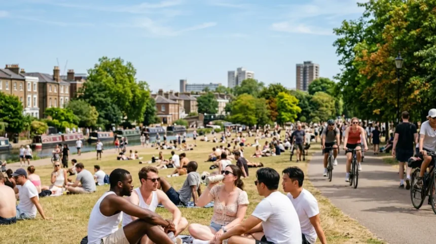
Urban heat islands amplify heatwave effects in London where concrete traps warmth, raising nighttime lows, with the southeast especially London topping 30°C and urban areas even warmer than surrounding regions. The southeast, particularly London, experiences enhanced temperatures due to urban infrastructure that absorbs and retains heat.
Research mapping London’s heat wave vulnerability index reveals significant spatial clustering of high heat vulnerability areas in central and east London, which co-occur with areas of potentially high heat exposure. East London specifically shows elevated vulnerability combining both exposure and social factors.
Based on vulnerability factors, the highest values appear in London Boroughs of Hackney, Islington, and Tower Hamlets—all located in East London. These boroughs face the most severe heat risk combining high exposure with vulnerable populations. Lowest vulnerability values appear in Bromley, Richmond upon Thames, and Sutton.
The urban heat island effect works through concrete and building materials absorbing solar radiation during the day and releasing it slowly at night. This process prevents nighttime cooling that rural areas experience, maintaining elevated temperatures continuously. East London’s dense urban fabric intensifies this effect compared to less developed areas.
East London’s vulnerability combines high heat exposure with demographic factors including older populations, people with long-term illnesses, and lower socioeconomic status. This combination creates compounded risk during heatwaves. The spatial clustering means certain East London neighborhoods face particularly severe impacts.
What historical temperature records demonstrate UK heatwave intensity?
The UK’s new record-high temperature of 40.3°C at Coningsby, Lincolnshire, was confirmed by the Met Office on 17 July 2022, beating the previous record of 38.7°C at Cambridge Botanic Garden in 2019 by 1.6°C. This represented the first time 40°C was provisionally exceeded in the UK, marking a historic climate milestone.
The 2022 heatwave produced the hottest day ever seen in the UK with 40.3°C provisionally recorded around 4pm on Tuesday 19 July. This exceeded the previous record by 1.6°C, demonstrating the intensifying nature of UK heat events. The temperature record tumble during this heatwave showed multiple records breaking simultaneously.
London experienced extreme temperatures during the 2022 heatwave, with conditions putting pressure on transport and health services. The Met Office warned of worse to come as temperatures soared over 39°C across the country. This event established the baseline for what constitutes extreme heat in the modern UK climate.
The 2019 record of 38.7°C at Cambridge Botanic Garden had stood for three years before the 2022 breakthrough. This relatively short record duration indicates accelerating temperature increases. The 1.6°C margin between records represents a significant jump in climate terms.
These historical records demonstrate the increasing frequency and intensity of UK heatwaves. The progression from 38.7°C to 40.3°C in just three years shows rapid climate change impacts. Current forecasts of 32-34°C, while below the absolute record, represent exceptional June temperatures that previously would have been unprecedented.
What infrastructure and environmental impacts occur during UK heatwaves?
Heatwaves create impacts on transport systems, health services, agriculture, and water resources, with the 2022 event putting pressure on transport and health services while temperatures soared. The sustained nature of heatwaves creates cumulative stress on infrastructure systems designed for typical UK temperatures.
Transport infrastructure faces significant challenges during extreme heat. Railway tracks can buckle under temperatures exceeding design specifications, causing service disruptions. Road surfaces may soften or crack, creating safety hazards. Airports experience delays as extreme heat affects aircraft performance and runway conditions.
Health services experience surges in demand during heatwaves. NHS England reported visits to the heat exhaustion advice page rose 552% during one heatwave warning period. Emergency calls increase for heat-related illnesses, particularly among vulnerable populations. Hospitals face capacity pressure as heat-related admissions surge.
Agriculture faces crop stress, livestock welfare issues, and water scarcity during prolonged heat. Crops experience reduced yields when temperatures exceed optimal ranges. Livestock require additional cooling and water resources. Water demand for irrigation increases dramatically, straining supply systems.
Water resources face depletion during sustained hot periods. River levels drop, reservoir capacity decreases, and groundwater recharge slows. This creates supply constraints for domestic, agricultural, and industrial use. Water companies may issue hosepipe bans to conserve resources during extended heatwaves.
Energy systems experience increased demand for cooling while facing reduced efficiency. Power generation plants operate less efficiently at high temperatures. Electricity demand surges for air conditioning and cooling systems. This creates grid stress during peak heat periods.
How should East London residents prepare for and respond to heatwave conditions?
Residents should drink plenty of cold drinks especially when exercising, take cool baths or showers, wear light-coloured loose clothing, sprinkle water over skin or clothes, avoid sun between 11am and 3pm, avoid excess alcohol, avoid extreme exercise, and seek medical advice if symptoms worsen or don’t go away. The NHS provides specific guidance for checking heat exhaustion signs and cooling procedures.
Keep homes cool by closing windows during the day and opening them at night once temperatures fall. Electric fans help if temperatures stay below 35°C. Wear sunscreen, hats, and light clothes while avoiding exercise, alcohol, caffeine, and hot drinks. Opt for cold food and drinks instead of hot meals.
Contact your doctor, pharmacist, or NHS Direct if worried about health during heatwave, especially if taking medication, feeling unwell, or experiencing unusual symptoms. Watch for cramp in arms, legs, or stomach, feelings of mild confusion, weakness, or problems sleeping. Rest for several hours, keep cool, and drink water or fruit juice if these symptoms appear.
Move heat exhaustion victims to cool places, remove unnecessary clothing, give cool water or sports drinks, and cool skin by spraying cool water or fanning. Stay out of sun where possible, especially between 11am and 3pm. These immediate actions prevent progression to heatstroke.
Vulnerable people should check on elderly neighbors, ensure children have adequate cooling, and monitor anyone with long-term conditions. Care homes and support services should implement heat protocols. Manual workers should request flexible scheduling to avoid peak heat hours. Sports participants should reduce intensity during extreme heat.

What does the current heatwave forecast indicate for future UK climate trends?
The shift in likelihood toward hot conditions is consistent with the long-term trend of rising UK temperatures linked to global climate change, meaning what we consider ‘average’ is gradually shifting over time. The Met Office’s 3-Month Outlook indicates hot summer conditions are 2.3 times more likely than normal, reflecting climate change impacts.
The current heatwave forecast of 32-34°C in June represents temperatures “pretty unusual even for the middle part of June,” according to Met Office meteorologist Alex Deakin. This exceptional nature aligns with climate change projections showing increasing frequency of extreme heat events.
Historical records demonstrate accelerating temperature increases. The progression from 38.7°C in 2019 to 40.3°C in 2022 shows rapid intensification. Current forecasts, while below absolute records, represent exceptional June temperatures previously unprecedented, indicating the baseline is shifting.
The Outlook reflects the balance of probabilities across different possible outcomes rather than predicting single fixed patterns. Even in seasons where hot conditions are more likely, the UK experiences mixed weather types. A generally hot season can still include cooler or unsettled spells, demonstrating continued variability within the shifting baseline.
Climate change drives the gradual shift in what constitutes average UK temperature. The elevated probability of hot conditions reflects this long-term trend. Future heatwaves will likely become more frequent, intense, and longer-lasting as the baseline continues shifting upward.
The Met Office emphasizes that shorter-range forecasts remain essential for planning despite seasonal outlooks providing useful context. The nearer we get to particular times, forecasts become more detailed and reliable. Residents should combine seasonal outlook understanding with current forecasts for optimal preparation.
What is a UK heatwave according to the Met Office?
A UK heatwave is defined by the Met Office as at least three consecutive days with maximum temperatures meeting or exceeding a location’s regional heatwave threshold, which ranges from 25°C to 28°C depending on the area.
