Shadwell is a historic riverside neighbourhood in the London Borough of Tower Hamlets, East London. Located between Wapping and Limehouse, it combines former dockland infrastructure, Thames-side walking routes, historic churches, landscaped public gardens and waterside recreation. Its identity reflects centuries of maritime trade, industrial development and urban regeneration. towerhamlets.gov.uk+1
- What makes Shadwell a distinctive place to explore in East London?
- How did Shadwell develop from a riverside settlement into a dockland neighbourhood?
- Where can visitors enjoy riverside walks around Shadwell?
- What can visitors see at Shadwell Basin?
- Which historic churches and architectural landmarks should visitors see in Shadwell?
- Where can visitors find gardens and green spaces near Shadwell’s waterfront?
- What outdoor activities are available at Shadwell Basin?
- How can visitors explore Shadwell’s wildlife and natural environment?
- What can visitors discover about Roman Shadwell?
- How can visitors plan a walking route around Shadwell’s historic places?
- How can visitors reach Shadwell and travel around the neighbourhood?
- When is the best time to visit Shadwell’s riverside attractions?
- Why is Shadwell important to East London’s heritage and future?
For visitors, Shadwell offers a way to explore East London beyond its major tourist attractions. Shadwell Basin provides a waterside setting, St George-in-the-East reveals the area’s architectural heritage, and nearby riverside paths connect visitors with historic docklands and local green spaces.
What makes Shadwell a distinctive place to explore in East London?
Shadwell is a historic East London neighbourhood where former docks, riverside paths, historic churches and public gardens reveal the area’s maritime past. Its location between Wapping and Limehouse makes it a useful starting point for exploring London’s changing waterfront.
Shadwell sits on the northern bank of the River Thames, east of the City of London. Its landscape developed around shipping, river transport, dock labour and residential communities that served the capital’s commercial economy. Today, residential streets and modern developments occupy much of the ground once associated with working docks.
The neighbourhood belongs to the London Borough of Tower Hamlets, a borough containing several historically important East End districts. Shadwell’s local character comes from the relationship between its older streets, surviving religious buildings, former dock basins and newer housing.
The waterfront is particularly significant. Shadwell Basin preserves a visible connection with the London Docks, while nearby open spaces provide opportunities for walking, birdwatching and outdoor recreation. Visitors can explore these features without planning a full-day excursion.
Shadwell also offers a practical introduction to the wider history of East London. Its buildings and public spaces demonstrate how a working maritime district became part of a densely populated urban area while retaining elements of its historic layout.
How did Shadwell develop from a riverside settlement into a dockland neighbourhood?
Shadwell developed from a riverside settlement into a maritime community as London’s shipping trade expanded. Its growth accelerated during the seventeenth century, followed by dock construction in the nineteenth century and residential redevelopment after the London Docks closed.
Shadwell’s recorded history extends back to the medieval period. Historical accounts refer to the settlement in 1325, although its development into a substantial urban community occurred later. Its name is associated with an ancient well, often connected with St Chad, although the precise etymology remains uncertain.
During the seventeenth century, expanding maritime commerce encouraged settlement along this section of the Thames. Shipbuilding, shipping services and related industries supported workers, merchants and local businesses. Shadwell became a separate parish in 1669, reflecting its growing population and established community.
The nineteenth century brought major physical changes. Shadwell Basin opened in 1832 as part of the expanding London Docks system. The docks supported the movement and storage of goods entering and leaving London, while nearby streets housed people working in maritime industries.
The decline of traditional commercial docks transformed the area again. The London Docks system closed in 1969, leaving large areas of former industrial land available for redevelopment. Subsequent regeneration introduced housing, landscaped spaces and recreational facilities.
The modern neighbourhood therefore contains several layers of history: medieval settlement, seventeenth-century urban growth, nineteenth-century dock infrastructure and late twentieth-century regeneration. Walking between its churches, streets and waterfront reveals these changes in the physical environment.
For a fuller historical overview, explore the [insert anchor text for Shadwell’s historical background article here] to understand how maritime commerce, parish development and dockland redevelopment shaped the neighbourhood.
Where can visitors enjoy riverside walks around Shadwell?
Shadwell’s waterfront offers walks around former dock basins, landscaped quays and connections towards the River Thames. Visitors can combine the Shadwell Basin perimeter with nearby Wapping paths, riverside viewpoints and routes towards Limehouse for a varied East London walk.
The best starting point for a waterfront excursion is Shadwell Basin. Its open water, dock walls and surrounding buildings create a distinctive environment for a relaxed walk. The area is especially useful for visitors interested in the relationship between historic industrial infrastructure and modern residential development.
Walking beside the basin reveals the scale of the former dock system. The waterway once served commercial shipping, whereas its present setting supports leisure activities and public access. The contrast illustrates the wider transformation of London’s historic waterfront.
Visitors can extend their walk towards Wapping, where riverside streets and former dockland areas offer additional opportunities to explore London’s maritime landscape. Routes towards Limehouse provide further connections with the Thames and the wider Docklands area.
The exact distance depends on the chosen route and any diversions around buildings or access points. Visitors should follow public paths and local signs rather than assume that every section of the waterfront forms a continuous riverside promenade.
Walking conditions also change with the weather. Wet surfaces, narrow paths and waterside edges require care, particularly for families with children. Visitors planning longer walks should check route access before setting out.
For a shorter outing, concentrate on the basin and nearby streets. For a longer excursion, continue towards Wapping or Limehouse and use public transport to return to the starting point.
What can visitors see at Shadwell Basin?
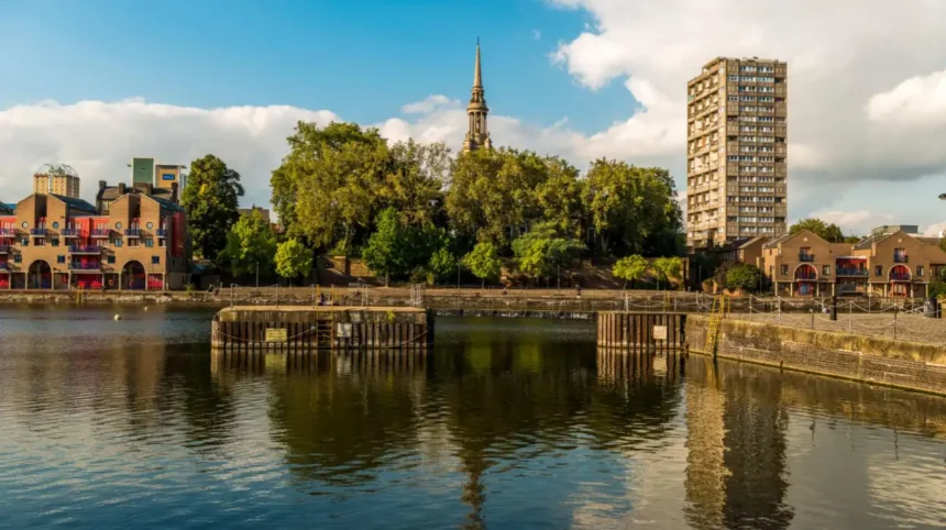
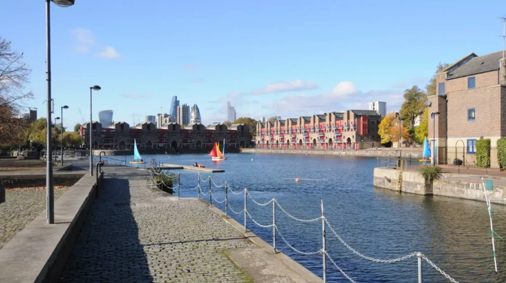
Shadwell Basin is a former dock basin that now combines waterside public space, residential development and organised outdoor activities. Its open water, surviving dock walls and surrounding quays provide a clear view of how London’s industrial waterfront has been adapted.
Shadwell Basin is one of the neighbourhood’s defining landmarks. Its significance comes from both its industrial history and its present recreational use. The basin retains a direct physical connection with the dock network that once supported London’s overseas trade.
The surrounding environment includes waterside paths, residential buildings and sections of historic dock infrastructure. These features make the area relevant to visitors interested in industrial heritage, architecture and the regeneration of East London.
The basin is also a useful location for observing how public space functions within a residential neighbourhood. People use the surrounding area for walking, meeting and accessing outdoor activities, while the water remains central to its identity.
Visitors should distinguish between the public waterside environment and facilities operated by activity providers. Access to organised water sports, changing rooms and specialist equipment depends on the relevant centre’s arrangements.
The basin is best explored at walking pace. Pausing along the water’s edge allows visitors to examine the dock walls, surrounding buildings and changing relationship between the former industrial site and the modern neighbourhood.
Which historic churches and architectural landmarks should visitors see in Shadwell?
Shadwell’s architectural heritage includes St George-in-the-East, St Paul’s Shadwell and surviving features associated with the former dockland landscape. These buildings and their surrounding spaces reveal the neighbourhood’s religious history, changing population and redevelopment over several centuries.
St George-in-the-East
St George-in-the-East is one of Shadwell’s most significant architectural landmarks. Designed by Nicholas Hawksmoor, an English architect associated with major eighteenth-century churches in London, it was constructed between 1714 and 1729. Its substantial form and distinctive tower make it an important example of London’s early eighteenth-century ecclesiastical architecture.
The church suffered severe damage during the Second World War. An incendiary bomb struck it in May 1941, leaving the outer walls and several important architectural elements standing. Its surviving structure records both the original design and the destruction that affected East London during the Blitz. National Churches Trust
Visitors can examine the building’s exterior and distinctive roofline. Access to the interior depends on church arrangements and services, so visitors should check before planning a visit.
St Paul’s Shadwell
St Paul’s Shadwell is another important landmark associated with the neighbourhood’s parish history. An earlier chapel was established in the seventeenth century, and the parish church was subsequently rebuilt in 1820. Its setting near the former dockland area connects religious history with the growth of the surrounding maritime community.
The church’s prominent spire forms part of the local skyline. Its relationship with nearby housing, former dock infrastructure and public space demonstrates how religious buildings remained important reference points as Shadwell changed.
Historic dock walls and the waterside landscape
Shadwell’s heritage is not limited to buildings designed for religious purposes. Former dock walls and surviving water channels also preserve evidence of industrial activity.
The dock walls around Shadwell Basin provide a tangible connection with the nineteenth-century port. Their scale and construction help visitors understand the engineering required to create enclosed dock water and manage the movement of vessels.
Together, the churches and dock infrastructure provide complementary views of Shadwell’s development. One reflects religious and community life; the other records the commercial activity that shaped the riverside economy.
Where can visitors find gardens and green spaces near Shadwell’s waterfront?
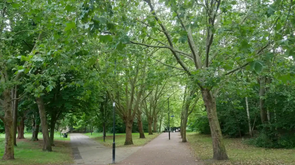
Visitors can explore St George’s Gardens, Wapping Wood and nearby King Edward Memorial Park for green space close to Shadwell’s historic waterfront. These locations offer landscaped paths, trees, open areas and opportunities to pause between architectural and riverside attractions.
St George’s Gardens
St George’s Gardens occupies the former churchyard of St George-in-the-East. The gardens opened to the public in 1875 and now provide a green space surrounded by the area’s urban streets.
Tower Hamlets Council identifies the gardens as a historic public garden covering approximately 1.19 hectares. Conservation work has preserved important monuments and walls while improving paths, planting and grassed areas. Heritage interpretation panels provide further information about the site. towerhamlets.
The gardens are particularly useful for visitors who want to combine architectural exploration with a quiet outdoor stop. Their historic connection with the church makes them more than an ordinary green space.
Wapping Wood
Wapping Wood lies near Shadwell Basin and forms part of the wider network of former dockland spaces. Its woodland and meadow-style landscaping introduce a natural element into an area shaped by industrial development.
The site is associated with the Shadwell and Hermitage Basins, Wapping Wood and Wapping Canal local wildlife area. The wider designated area covers approximately 6.66 hectares and contains open water, grassland, aquatic plants and habitats used by birds.
Visitors interested in urban nature can look for common birds and observe how trees and vegetation occupy spaces between residential development and former waterways. Wildlife sightings vary according to season, weather and disturbance.
King Edward Memorial Park
King Edward Memorial Park provides another option for visitors exploring the Thames-side area. The park occupies land associated with the former Shadwell Fish Market estate and extends the relationship between the local neighbourhood and the river.
It is a practical addition to a longer walk, particularly for visitors who want open space alongside historic waterfront scenery. Its position also helps connect Shadwell’s dockland heritage with the broader public spaces along the Thames.
Visitors should check local access information before travelling, particularly if a route includes construction areas or temporary closures.
What outdoor activities are available at Shadwell Basin?
Shadwell Basin supports organised outdoor activities through a specialist activity centre offering water sports and adventure sessions. Activities include kayaking, canoeing, sailing, paddleboarding and climbing, with availability depending on age, course schedules and booking arrangements.
The Shadwell Basin Outdoor Activity Centre operates at 3–4 Shadwell Pierhead, Glamis Road, London E1W 3TD. It is a registered charity that provides opportunities for children, young people and adults to participate in outdoor activities.
Visitors can investigate several types of activity:
- Paddlesports: Kayaking, open canoeing and stand-up paddleboarding provide ways to experience the basin from the water.
- Sailing: Introductory sessions and structured courses provide opportunities to develop sailing skills.
- Climbing: Organised climbing and high-ropes sessions offer land-based activities alongside the watersports programme.
These activities are organised experiences rather than unrestricted use of the basin. Participants should check current timetables, minimum ages, prices, equipment requirements and booking conditions directly with the centre.
The Health and Safety Executive’s Adventure Activities Licensing Authority lists the provider under licence reference R0539, with an expiry date of 20 July 2028. Its listed activity categories include watersports, climbing, caving and trekking. Visitors should still confirm the arrangements for their chosen session.
The centre also accommodates organised groups and corporate events. This makes Shadwell a practical option for visitors combining leisure with a group activity, although advance arrangements are necessary.
For travellers who prefer a quieter visit, simply walking around the basin provides a way to appreciate the waterside environment without joining an organised session.
How can visitors explore Shadwell’s wildlife and natural environment?
Shadwell’s former dock basins, nearby woodland and landscaped waterfront support urban wildlife within a densely developed part of East London. Visitors can observe waterbirds, garden birds and vegetation while walking, provided they respect wildlife habitats and keep to accessible paths.
The relationship between nature and former industrial infrastructure is a defining feature of Shadwell’s waterfront. Dock basins were built for commercial use, but their water, edges and surrounding vegetation now support ecological activity.
The Shadwell and Hermitage Basins, Wapping Wood and Wapping Canal area is recognised as a Site of Importance for Nature Conservation. The designated area includes open water, aquatic plants, grassland and habitats for breeding and wintering birds.
Wildlife recorded in the area includes mute swans, Egyptian geese, common terns, sand martins and other bird species. The precise species seen during a visit depends on the season and local conditions.
Visitors can make wildlife observation part of an ordinary walk. Looking across the water, checking tree canopies and observing vegetation around quieter sections of the route provide opportunities to notice the local environment without specialist equipment.
Binoculars can help with distant birds, while a camera with a zoom lens supports photography without approaching wildlife. Visitors should avoid feeding birds, disturbing nesting sites or entering restricted areas.
The area’s ecological value also illustrates a broader feature of urban regeneration: former industrial spaces can retain environmental importance when water, vegetation and wildlife habitats remain part of the landscape.
What can visitors discover about Roman Shadwell?
Shadwell has archaeological evidence of Roman settlement dating from the second and third centuries AD. The remains include a Roman bath house near The Highway, demonstrating that this section of the Thames supported activity long before the area’s later maritime and dockland expansion.
The Roman settlement provides an important historical dimension to Shadwell. Historic England identifies a settlement associated with the eastern approach to Londinium, the Roman city that occupied the area of present-day central London.
The settlement developed near a former Thames channel and a stream flowing from the north. Archaeological evidence indicates activity from the second century AD, with more substantial development during the third century. The settlement was abandoned in the early fifth century. Historic England+1
The Roman bath house, dated to approximately the mid-second to mid-third century AD, is particularly significant. Roman bath houses contained facilities for bathing at different temperatures, supported by heating systems and engineered water supplies.
At Shadwell, the remains are preserved in situ beneath modern development. This means the archaeological structure remains in its original location rather than being displayed as a freestanding monument in a conventional museum. Consequently, visitors should not expect an open excavation site.
Historic England’s designation of the site highlights its archaeological importance. The remains provide evidence of settlement and commercial activity close to the Thames, linking Shadwell’s early history with the development of Roman London.
Although the Roman bath house is not a typical walk-in attraction, it adds depth to an exploration of the neighbourhood. Shadwell’s history extends far beyond the nineteenth-century docks that dominate its modern waterfront identity.
How can visitors plan a walking route around Shadwell’s historic places?
A practical Shadwell walking route combines the former dock basin, historic churches, public gardens and nearby riverside spaces. Visitors can explore these attractions on foot, adjust the distance to their available time and use local transport for onward journeys.
A self-guided walk works well because Shadwell’s principal attractions are connected through the surrounding urban street network. The route should account for road crossings, access points and the fact that not every waterside section forms an uninterrupted public path.
A suggested sequence is:
- Begin at Shadwell Basin. Explore the dock walls, surrounding quays and waterside environment.
- Continue to St Paul’s Shadwell. Examine the church’s exterior and its relationship with the former maritime neighbourhood.
- Visit St George-in-the-East. Observe the architecture and learn about the church’s eighteenth-century origins and wartime damage.
- Walk through St George’s Gardens. Take time to explore the historic churchyard and its preserved monuments.
- Extend the walk towards Wapping Wood or King Edward Memorial Park. Choose the option that best suits your interest in woodland, open space or riverside scenery.
The sequence is a suggested itinerary, not a guarantee of uninterrupted access between every attraction. Check current pedestrian routes and opening arrangements before setting out.
Visitors with limited time can concentrate on Shadwell Basin and St George-in-the-East. Those with a longer break can add the gardens and nearby green spaces. Allow additional time for photography, rest stops and any booked activities.
Comfortable walking shoes are useful because the route includes ordinary pavements and potentially uneven or wet waterside surfaces. Carry water and check the forecast, particularly when planning an extended outdoor visit.
How can visitors reach Shadwell and travel around the neighbourhood?
Shadwell is served by London Overground and Docklands Light Railway services at Shadwell station. Visitors can use these connections to reach the neighbourhood and continue exploring East London, checking live service information before travelling.
Shadwell station is a convenient starting point for exploring the area’s streets and waterfront. The station serves both London Overground and Docklands Light Railway (DLR) services, providing connections with other parts of the capital.
Walking is generally the most practical way to explore the local attractions once in the neighbourhood. However, visitors should check the distance between individual sites and choose an accessible route that suits their mobility needs.
For a wider East London itinerary, Shadwell can be combined with Wapping and Limehouse. These neighbouring areas have their own historic streets, former dockland landscapes and connections to the River Thames.
Travellers should check Transport for London’s journey planner for current departures, service disruptions and step-free access information. They should also verify walking directions before departure rather than relying on an assumed route between waterfront locations.
Explore More Area Guide
Discover Whitechapel: Museums, Heritage and Cultural Attractions
Bow East London: Heritage, Historic Landmarks and Attractions
When is the best time to visit Shadwell’s riverside attractions?
Shadwell’s riverside attractions can be explored throughout the year, with the best timing depending on daylight, weather and planned activities. Longer daylight hours suit extended walks and photography, while organised watersports require advance checks with the activity centre.
Spring and summer provide longer daylight periods for walking between Shadwell Basin, historic churches and public gardens. These seasons also provide opportunities to observe birds and vegetation around the local waterways.
Autumn brings changing foliage to green spaces such as Wapping Wood. Shorter days make it important to plan routes before dusk, particularly when visiting less familiar streets or sections of the waterfront.
Winter visits remain possible, but wet weather and reduced daylight require additional care. Visitors should wear suitable footwear and avoid approaching unprotected dock edges.
There is no single time that suits every visitor. Architecture enthusiasts can focus on daylight hours when building details are easy to see. Wildlife observers can allow extra time to watch the water and surrounding vegetation. Visitors booking sailing or paddlesports should follow the centre’s published schedule and weather-related instructions.
Before travelling, check the opening arrangements for churches and gardens, the availability of booked activities and any temporary restrictions affecting public paths.
Why is Shadwell important to East London’s heritage and future?
Shadwell demonstrates how East London’s historic waterfront has evolved from a centre of maritime trade into a mixed residential, recreational and heritage landscape. Its surviving dock infrastructure, historic churches and public green spaces continue to connect the neighbourhood’s past with contemporary urban life.
The area’s future relevance lies in the continued use of its historic environment. Shadwell Basin supports organised outdoor activities, while its surrounding paths provide access to waterside public space. Historic churches and gardens preserve architectural and community heritage within a changing urban neighbourhood.
The area’s ecological features also contribute to its significance. Open water, trees and grassland provide habitats within the wider built environment. Maintaining these spaces supports wildlife and gives residents and visitors opportunities to experience nature without leaving East London.
Shadwell’s heritage is therefore not confined to individual landmarks. It exists in the relationship between the river, former docks, religious buildings, residential streets and public spaces. Understanding these connections gives visitors a more complete view of the neighbourhood’s development.
For tourists, Shadwell offers a compact introduction to East London’s maritime history and changing waterfront. For residents, it provides access to historic places, outdoor recreation and neighbourhood green spaces. For business travellers and digital nomads, the location offers opportunities to use spare time for walking and local exploration.
A visit to Shadwell ultimately reveals several stages of London’s history in one neighbourhood, from Roman settlement and early parish development to nineteenth-century dock expansion and modern regeneration.
What is Shadwell famous for?
Shadwell is known for its maritime history, Shadwell Basin, historic churches, former docklands and riverside walking routes. It offers visitors a glimpse into East London’s industrial past and modern waterfront regeneration.