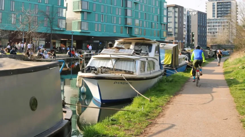
The Regent’s Canal around Mile End and Tower Hamlets offers one of East London’s most distinctive waterside walking experiences. This historic waterway connects green spaces, industrial heritage, residential neighbourhoods and regenerated docklands. Its towpaths provide opportunities for walking, cycling, photography, wildlife observation and peaceful outdoor recreation away from busy main roads.
- What Is the Regent’s Canal and Where Does It Run Through Mile End?
- Why Is the Regent’s Canal Historically Important to Tower Hamlets?
- How Did the Canal Support East London’s Industries?
- How Did the Canal Change After Commercial Transport Declined?
- Which Parts of the Regent’s Canal Are Best for Walking Around Mile End?
- What Historic Bridges Can Visitors See Along the Mile End Canal?
- What Makes Mile End Park an Important Canal-Side Green Space?
- What Can Visitors Explore Inside Mile End Park?
- Why Is the Green Bridge Significant?
- Can Visitors Observe Wildlife in Mile End Park?
- How Does the Regent’s Canal Connect with Victoria Park and Hertford Union Canal?
- What Can Visitors Discover Around Limehouse Basin?
- What Wildlife and Natural Scenery Can Visitors Find Along the Canal?
- Which Birds Can Visitors Observe?
- What Insects and Aquatic Habitats Are Present?
- How Can Visitors Enjoy Wildlife Responsibly?
- Which Outdoor Activities Are Available Along the Regent’s Canal?
- Walking and Leisure Strolls
- Cycling Along the Canal
- Photography and Urban Landscapes
- Running and Outdoor Exercise
- Picnics and Family Activities
- How Can Visitors Plan a Walking Route Around Mile End and Tower Hamlets?
- What Is a Suitable Short Walking Route?
- What Is a Suitable Longer Walking Route?
- Can Visitors Combine the Canal with Nearby Attractions?
- How Accessible Is the Regent’s Canal Around Mile End?
- Which Transport Options Serve the Area?
- Are the Canal Paths Suitable for Wheelchair Users?
- What Facilities Are Available Nearby?
- What Is the Best Time to Explore Regent’s Canal in Mile End?
- What Are the Conservation and Environmental Challenges Facing Regent’s Canal?
- How Is the Canal’s Historic Character Protected?
- Why Is Wildlife Protection Important?
- How Does Urban Development Affect the Canal?
- Why Should the Regent’s Canal Be Included in an East London Travel Itinerary?
The Mile End section is particularly attractive because the canal runs alongside Mile End Park, passes historic bridges and locks, and connects with other waterways leading towards Victoria Park and Limehouse Basin. Visitors experience a combination of traditional canal architecture, narrowboats, landscaped green spaces and surviving industrial structures.
For tourists, the area provides an accessible way to explore East London’s history and outdoor environment. Local residents use the towpath for everyday exercise, while visitors with limited time can combine a short canal walk with nearby parks, cultural attractions and historic landmarks.
What Is the Regent’s Canal and Where Does It Run Through Mile End?
The Regent’s Canal is a historic 13.8-kilometre London waterway connecting the Grand Union Canal at Paddington with Limehouse Basin and the River Thames. Around Mile End, it passes through Tower Hamlets, linking residential neighbourhoods, historic bridges, public parks and waterways.
The Regent’s Canal forms part of London’s wider inland waterway network. It was constructed to transport commercial goods between the River Thames, western London and industrial destinations further inland.
The canal passes through several well-known London neighbourhoods, including Little Venice, Regent’s Park, Camden, King’s Cross, Islington, Hackney and Mile End. Its eastern section reaches Limehouse Basin, where boats connect with the River Thames.
The Mile End stretch occupies an important position within this network. It provides a waterside connection between the Victoria Park and Old Ford areas to the north and Limehouse towards the south.
Unlike busy roads, the canal follows a relatively continuous waterside corridor. The towpath allows pedestrians to experience different parts of East London without constantly crossing major traffic routes.
The surrounding environment changes along the route. Visitors encounter:
- Historic brick bridges, including Globe Bridge and Gunmakers Arms Bridge.
- Canal locks, including Mile End Lock.
- Green spaces, including Mile End Park.
- Residential and university buildings around Mile End Road.
- Moorings and narrowboats along the waterway.
- Connections towards Limehouse Basin and the River Thames.
The canal therefore functions as both a historic transport route and a modern recreational corridor.
Why Is the Regent’s Canal Historically Important to Tower Hamlets?
The Regent’s Canal transformed East London’s transport network by connecting the Thames with inland waterways. Completed in 1820, it supported the movement of coal, timber, construction materials and food before railways and road transport reduced commercial canal traffic.
The canal’s development began with proposals made in the early nineteenth century. Thomas Homer promoted the idea of connecting the Grand Junction Canal at Paddington with Limehouse, where commercial vessels could access the Thames.
The Regent’s Canal Company was established in 1812. Architect John Nash helped secure support for the project, while engineer James Morgan oversaw important construction work.
The canal opened in two main stages. The Paddington-to-Camden section opened in 1816, followed by the Camden-to-Limehouse section in 1820.
Its construction cost approximately £772,000, substantially exceeding the original estimates. Despite the expense, the completed waterway provided an important commercial connection between London’s docks and inland trading routes.
How Did the Canal Support East London’s Industries?
During the nineteenth and early twentieth centuries, the canal transported goods required by London’s growing population and industrial economy.
Coal supplied domestic heating and industrial energy. Timber supported construction and manufacturing. Food deliveries helped supply London’s markets, while building materials supported expanding residential and commercial districts.
The waterway also connected industries around East London with larger distribution networks.
Mile End’s position along the canal made it part of this wider transport system. Warehouses, industrial buildings, bridges and wharves developed around the waterway to support commercial activity.
How Did the Canal Change After Commercial Transport Declined?
Railways and motor vehicles gradually replaced canal boats as the principal method of transporting commercial goods. Commercial traffic declined considerably during the twentieth century.
The Regent’s Canal Dock at Limehouse closed to shipping in 1969. The decline of traditional freight activity changed the character of the surrounding waterfront.
Canal restoration, residential development and improvements to public access subsequently created new recreational uses.
Today, walking, cycling, boating and waterside tourism form important parts of the canal’s identity. The historic infrastructure remains visible throughout the Mile End section.
As you explore the modern canal, you are crossing land shaped by centuries of transport and industrial development. Read about the full [Historical Development of Regent’s Canal and Its Industrial Heritage in East London] to understand how the waterway transformed the surrounding neighbourhoods.
Which Parts of the Regent’s Canal Are Best for Walking Around Mile End?
The best walking sections around Mile End include the towpath beside Mile End Park, the route towards Mile End Lock, and the northern stretch towards Old Ford Lock. These sections combine historic canal infrastructure, greenery, narrowboats and connections to surrounding neighbourhoods.
The Mile End towpath offers a practical starting point for visitors interested in exploring the canal without undertaking a long-distance London walk.
The route provides access to several local landmarks and green spaces. Its relatively flat character makes it suitable for ordinary recreational walking, although towpath surfaces and available access points vary.
Mile End Park to Mile End Lock
This section combines canal scenery with the landscaped environment of Mile End Park.
Visitors can follow the towpath beside the park, observe moored boats and look towards the historic canal structures. Mile End Lock provides an important point of interest because it demonstrates how canal infrastructure manages changes in water level.
The lock also retains physical evidence of historical transport activity. Grooves worn into the stone by ropes used to tow working boats remain visible around the structure.
The nearby Queen Mary University of London campus adds another dimension to the route. Its buildings and historic surroundings demonstrate how educational institutions and public spaces occupy land previously associated with industrial transport.
Mile End Towards Old Ford Lock
The northern section connects the Mile End area with Old Ford and the Hertford Union Canal junction.
Old Ford Lock provides an opportunity to observe canal navigation infrastructure and boat movements. The surrounding area contains historic industrial sites alongside regenerated residential and recreational developments.
This stretch is particularly useful for visitors planning a longer waterside walk or connecting their canal visit with Victoria Park.
Mile End Towards Limehouse Basin
The southern direction leads towards Limehouse Basin.
This route passes under historic bridges and follows the canal through changing residential and urban landscapes. The approach to Limehouse introduces visitors to a wider basin containing moored boats and modern waterfront buildings.
The Canal & River Trust also identifies a walking route from Limehouse Basin towards Mile End, highlighting the towpath, bridges and historic features along the way.
What Historic Bridges Can Visitors See Along the Mile End Canal?
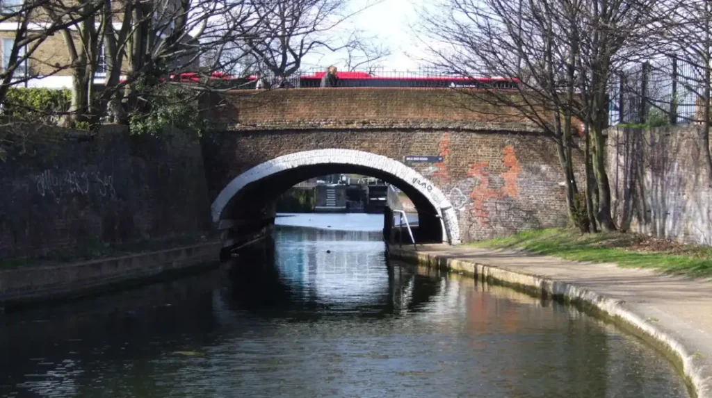
The Mile End stretch contains historic bridges that demonstrate the engineering and industrial development of Regent’s Canal. Globe Bridge, Gunmakers Arms Bridge and Mile End Road Bridge provide distinctive architectural features and useful reference points for exploring the surrounding towpath.
Bridges form an essential part of the canal’s structure. They allow roads, pedestrians and local transport routes to cross the waterway while maintaining navigation beneath them.
The bridges around Mile End also reflect different periods of London’s development.
Globe Bridge
Globe Bridge is an important historic structure near Mile End Road and Queen Mary University of London.
The bridge dates from 1820 and forms part of the surviving canal heritage around the university campus.
Its location makes it a useful landmark for visitors approaching the canal from Mile End Underground station or Mile End Road.
The surrounding conservation area recognises the importance of historic bridges, towpaths, locks and associated industrial buildings.
Gunmakers Arms Bridge
Gunmakers Arms Bridge is another notable feature along the canal.
Its brick construction reflects the industrial character of nineteenth-century East London. The bridge is associated with the area’s manufacturing history, including the former London Small Arms Factory.
During the First World War, the canal supported the movement of components between the factory’s industrial operations.
Visitors walking beneath the bridge encounter a physical connection between the canal’s transport function and East London’s manufacturing economy.
Mile End Road Bridge
Mile End Road Bridge connects two important parts of the local transport network.
It provides a crossing between the areas surrounding Mile End Road and the canal-side environment. The bridge also serves as a useful access point for visitors approaching from the Underground station.
Its position makes it convenient for shorter walking routes that combine the canal with nearby university buildings and Mile End Park.
What Makes Mile End Park an Important Canal-Side Green Space?
Mile End Park is a 32-hectare linear public park running alongside Regent’s Canal in Tower Hamlets. It combines landscaped gardens, lakes, woodland, sports facilities, children’s play areas and walking routes, creating an extensive green corridor through East London.
Mile End Park is one of the most important outdoor destinations connected to the canal.
Unlike traditional parks arranged around a central lawn, it follows a long, narrow layout. This design creates a continuous recreational environment between different parts of the borough.
The park was planned during the twentieth century. Its development included the reuse of land affected by Second World War bombing.
Tower Hamlets Council records that the park was first planned in 1943 and included in the 1944 Abercrombie Plan for Greater London. Some areas were developed as King George’s Fields in 1952, with further landscape improvements continuing over subsequent decades.
What Can Visitors Explore Inside Mile End Park?
The park contains several distinct recreational environments.
The Ecology Park includes lakes, reed beds and wildlife habitats. These areas provide opportunities to observe water birds, insects and other urban wildlife.
The Arts Park provides cultural facilities, including the Art Pavilion, which hosts exhibitions and events.
The Sports Park contains facilities for active recreation. Visitors also find playgrounds, open lawns, landscaped paths and areas suitable for informal relaxation.
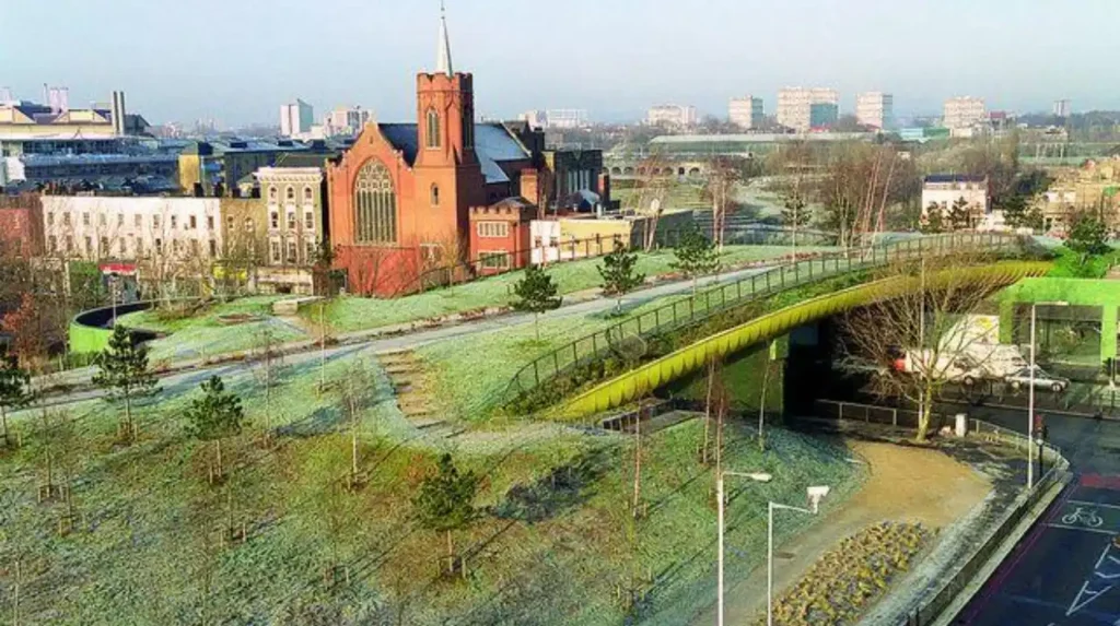
The Green Bridge is another recognisable feature. It carries the park across Mile End Road and creates a landscaped pedestrian connection between sections of the park.
Why Is the Green Bridge Significant?
The Green Bridge opened in July 1999 and was designed by architect Piers Gough.
It provides a pedestrian crossing over a busy road while maintaining the continuity of the park.
For canal visitors, it offers an alternative way to move between different green spaces without following the main road network.
The structure also demonstrates how urban landscape design connects recreational facilities with transport infrastructure.
Can Visitors Observe Wildlife in Mile End Park?
Mile End Park supports wildlife through its lakes, grasslands, woodland and planted areas.
Water birds use the wetland habitats, while insects benefit from flowering vegetation and meadow environments.
Tower Hamlets highlights the park’s biodiversity, including records of more than 400 beetle species and approximately 170 spider species.
The Ecology Park is particularly relevant for visitors interested in urban ecology and wildlife photography.
How Does the Regent’s Canal Connect with Victoria Park and Hertford Union Canal?
The Regent’s Canal connects with other East London waterways near Victoria Park and Old Ford. Hertford Union Canal provides a roughly two-kilometre connection towards the River Lee, creating additional opportunities for walking, cycling and exploring waterside landscapes.
The canal network around Mile End offers more than one walking direction. Visitors can extend their journey by following connecting waterways and exploring nearby public parks.
Victoria Park
Victoria Park is one of East London’s best-known public parks.
The park opened in 1845 and covers approximately 86 hectares. It contains lakes, ornamental gardens, historic monuments, playgrounds and extensive walking paths.
Visitors can combine a canal walk with a visit to the park’s landscaped grounds.
Important features include the Chinese Pagoda, the Victoria Fountain and the Dogs of Alcibiades sculptures. The park also provides opportunities for birdwatching and photography around its lakes.
Its location makes it a useful addition to a walking itinerary through Mile End and Old Ford.
Hertford Union Canal
Hertford Union Canal is a short waterway connecting Regent’s Canal with the River Lee.
It extends for approximately two kilometres and runs beside Victoria Park.
The canal provides a quieter walking and cycling connection towards Queen Elizabeth Olympic Park. Visitors can observe narrowboats, waterside vegetation and urban architecture along the route.
The waterway also has a practical navigation function. Boats use it as a shorter connection between Regent’s Canal and the River Lee without travelling around the Isle of Dogs and through the Thames.
Old Ford Lock
Old Ford Lock is an important navigation feature near the Hertford Union Canal junction.
Locks regulate water levels and allow boats to travel between canal sections at different elevations.
Visitors can observe boats entering and leaving the lock chambers. The surrounding environment combines traditional canal infrastructure with newer developments and landscaped public spaces.
This location is particularly useful for people extending a Mile End walk towards the Olympic Park.
What Can Visitors Discover Around Limehouse Basin?
Limehouse Basin marks the eastern connection between Regent’s Canal and the River Thames. Its marina, historic industrial structures, canal bridges and waterside paths provide a distinctive destination for visitors exploring the southern section of the Mile End canal route.
Limehouse Basin represents an important part of London’s maritime and industrial history.
It originally served as a transfer point between inland canal boats and vessels using the River Thames. Commercial cargo moved through the basin before continuing towards London’s docks and other destinations.
Today, the area has a different character. Residential developments, moorings, pedestrian routes and marina facilities have transformed the former industrial waterfront.
What Is Worth Seeing at Limehouse Basin?
The basin contains several historic and architectural features.
The Grade II-listed Accumulator Tower is particularly distinctive. Built in 1869, it formed part of the hydraulic power system used to operate equipment around the basin.
The tower regulated hydraulic pressure for machinery such as cranes, locks, capstans and swing bridges.
The nearby railway viaduct provides another example of the industrial infrastructure that developed around London’s transport network.
The basin’s modern marina also offers views of narrowboats and residential waterfront buildings.
The Canal & River Trust identifies Limehouse Basin as the final eastern destination of Regent’s Canal before its connection with the Thames.
Can Visitors Walk Around Limehouse Basin?
The basin provides a suitable setting for a shorter waterside walk.
The Canal & River Trust describes a circular walking route of approximately one mile around Limehouse Basin.
This route provides opportunities to observe historic infrastructure, boats and the surrounding waterfront.
Visitors can also continue towards Mile End by following the Regent’s Canal towpath. Canal & River Trust+1
What Wildlife and Natural Scenery Can Visitors Find Along the Canal?
The Regent’s Canal supports urban wildlife through its water, towpath vegetation, planted banks and nearby green spaces. Visitors around Mile End can observe water birds, insects and aquatic habitats while exploring the canal and adjoining parkland.
Although the canal passes through a densely developed part of London, its waterside environment provides important ecological features.
Water creates habitat for aquatic organisms, while vegetation along the banks provides shelter and feeding opportunities for birds and insects.
Which Birds Can Visitors Observe?
Canal visitors regularly encounter familiar urban water birds.
These include:
- Mallards, which are commonly found on urban waterways.
- Moorhens, which feed around aquatic vegetation.
- Coots, recognisable by their dark bodies and white frontal shields.
- Canada geese, which use canals and nearby park lakes.
- Mute swans, which are frequently associated with larger urban water spaces.
Bird activity changes according to season, weather and habitat conditions.
Mile End Park’s Ecology Park provides additional opportunities for observing water birds in a more natural setting.
What Insects and Aquatic Habitats Are Present?
Dragonflies and damselflies use wetland habitats during different stages of their life cycles.
Their larvae develop in water before emerging as flying adults. Reed beds and aquatic vegetation provide useful habitat around ponds and lakes.
Bees and butterflies also benefit from flowering plants and grassland areas within Mile End Park.
These habitats contribute to biodiversity within a heavily urbanised borough.
How Can Visitors Enjoy Wildlife Responsibly?
Responsible wildlife observation protects both animals and their habitats.
Visitors should avoid feeding birds with bread, disturbing nesting areas or throwing litter into the water.
Dogs should remain under control, and pedestrians should avoid damaging vegetation along narrow towpaths.
Photography is best undertaken from suitable standing areas without blocking other path users.
These practices help maintain the canal as a shared recreational and ecological environment.
Which Outdoor Activities Are Available Along the Regent’s Canal?
The Regent’s Canal around Mile End supports walking, cycling, running, photography, wildlife observation and narrowboat watching. Nearby parks also provide opportunities for picnics, playground visits and outdoor exercise, making the area suitable for different visitor interests.
The canal’s recreational value comes from its combination of accessible paths, waterside scenery and nearby public facilities.
Visitors can choose a short walk or incorporate the canal into a longer East London exploration.
Walking and Leisure Strolls
Walking is one of the simplest ways to explore the canal.
The Mile End section provides a relatively flat route with frequent opportunities to stop beside the water.
Visitors can observe bridges, narrowboats, locks and surrounding buildings without needing specialist equipment.
Comfortable footwear is recommended because towpath surfaces vary between paved, compacted and uneven sections.
Cycling Along the Canal
Cyclists use sections of the towpath as part of local journeys and recreational rides.
The canal provides a largely traffic-free alternative to nearby roads. However, pedestrians and cyclists share sections of the route.
Cyclists should slow down near pedestrians, bridges, blind corners and moored boats. They should give sufficient warning before passing and follow the Canal & River Trust’s towpath guidance.
Some sections are narrow, making considerate cycling particularly important.
Photography and Urban Landscapes
The canal offers several photographic subjects.
Historic brick bridges provide architectural details, while narrowboats create colourful foregrounds against the water.
Mile End Park adds natural scenery through its trees, lakes and landscaped banks.
The most useful photography opportunities include:
- Reflections of narrowboats in calm water.
- Brickwork and architectural details beneath bridges.
- Wildlife around the Ecology Park.
- Landscaped views from the canal-side paths.
- Industrial structures around Limehouse Basin.
Early morning and late afternoon provide changing natural light, although conditions depend on the season.
Running and Outdoor Exercise
The towpath and Mile End Park offer routes for everyday exercise.
Runners can use the canal as part of longer journeys between Mile End, Old Ford and Limehouse.
The park provides additional paths and open spaces for people who prefer running away from shared canal traffic.
Mile End Park Leisure Centre and Stadium also provide indoor and organised sports facilities nearby.
Picnics and Family Activities
The landscaped areas beside the canal provide opportunities for short breaks.
Mile End Park offers open grass areas, children’s play facilities and picnic spaces.
Families can combine a waterside walk with a visit to the playground or Ecology Park.
Visitors should check local notices for facility availability and park restrictions before travelling.
How Can Visitors Plan a Walking Route Around Mile End and Tower Hamlets?
Visitors can plan a canal walk by choosing a starting point around Mile End Road, Old Ford or Limehouse Basin. A shorter walk focuses on Mile End Park and Mile End Lock, while a longer journey connects historic waterways and nearby public parks.
The best route depends on available time, walking preferences and transport arrangements.
What Is a Suitable Short Walking Route?
A short route can focus on the central Mile End section.
Start near Mile End Underground station and walk towards Mile End Park. Follow the park paths to the canal and explore the towpath near Mile End Lock.
This route allows visitors to experience canal scenery, parkland and historic infrastructure without travelling a long distance.
Allow approximately 45–60 minutes for a relaxed visit, depending on stops and access arrangements.
What Is a Suitable Longer Walking Route?
A longer route connects Mile End with Old Ford and Limehouse.
Visitors can begin around Mile End Road, explore Mile End Lock and continue towards the northern canal sections.
Alternatively, walking south leads towards Limehouse Basin, where the canal meets the River Thames.
Allow approximately two to three hours for a leisurely one-way exploration from Mile End towards Limehouse, depending on the precise starting point and walking pace.
The Canal & River Trust’s published route provides useful guidance for exploring the southern section from Limehouse towards Mile End.
Can Visitors Combine the Canal with Nearby Attractions?
Yes. The canal provides convenient connections to several East London destinations.
Useful combinations include:
- Regent’s Canal and Mile End Park for greenery and waterside walking.
- Regent’s Canal and Victoria Park for lakes, gardens and historic monuments.
- Regent’s Canal and Hertford Union Canal for a longer waterside route.
- Regent’s Canal and Limehouse Basin for industrial heritage and marina scenery.
- Regent’s Canal and Queen Mary University of London for local architecture and campus surroundings.
These combinations allow visitors to build an itinerary around their interests rather than following one fixed walking route.
How Accessible Is the Regent’s Canal Around Mile End?
The Mile End canal area is accessible by public transport and connects with established walking routes through Mile End Park. However, towpath widths, surfaces, bridge approaches and access points vary, so visitors requiring step-free access should check individual sections before travelling.
Mile End is one of the more convenient starting points for exploring the canal.
Mile End Underground Station serves the Central, District and Hammersmith & City lines.
The surrounding area also has bus connections serving Mile End Road and nearby neighbourhoods.
Which Transport Options Serve the Area?
The Underground provides the most direct public transport connection for many visitors.
Mile End station offers access to the canal and surrounding parkland. Several bus services also operate around the area, including routes serving Mile End Road.
Visitors travelling from central London can use the Underground before walking towards the canal.
For Limehouse Basin, Limehouse station provides access through the DLR and National Rail services.
Are the Canal Paths Suitable for Wheelchair Users?
Accessibility varies across the canal route.
Mile End Park includes well-graded pedestrian paths and accessible routes. The council also provides accessibility information and visual route guidance for parts of the park.
However, canal towpaths contain narrow sections, bridges and uneven surfaces.
Visitors using wheelchairs or mobility aids should check the specific route and access points rather than assume that the entire canal is step-free.
The Canal & River Trust provides guidance on towpath access and responsible use. towerhamlets.gov.uk+1
What Facilities Are Available Nearby?
Facilities are concentrated around Mile End Park and nearby residential and commercial areas.
Visitors can find:
- Public transport connections around Mile End station.
- Leisure facilities at Mile End Park.
- Cafés and food outlets around the surrounding neighbourhood.
- Public open spaces and seating in the park.
- Cultural facilities at the Art Pavilion.
- Additional waterfront facilities around Limehouse Basin.
Not every facility is directly beside the towpath, so visitors should plan refreshments and toilet stops around nearby public destinations.
What Is the Best Time to Explore Regent’s Canal in Mile End?
Spring and summer provide longer daylight hours and opportunities to enjoy the canal’s vegetation, wildlife and nearby parks. Autumn offers changing foliage, while winter provides quieter walking conditions and clearer views of historic bridges and canal architecture.
The canal remains an outdoor destination throughout the year. Each season changes the surrounding landscape and the type of recreational experience available.
Spring
Spring brings new vegetation along the canal banks and surrounding green spaces.
Visitors can observe flowering plants, emerging leaves and increased insect activity. The Ecology Park provides opportunities to observe seasonal wildlife.
Mild temperatures also make spring suitable for longer walks.
Summer
Summer offers longer daylight hours and more opportunities for outdoor activities.
Visitors can combine canal walks with picnics in Mile End Park or explore the lakes and gardens in Victoria Park.
Weekends can become busy, particularly during warm weather and local events.
Autumn
Autumn brings changing leaf colours to the trees around the canal and nearby parks.
The combination of historic brickwork, reflective water and seasonal vegetation creates opportunities for landscape photography.
Cooler temperatures also make longer walking routes more comfortable for many visitors.
Winter
Winter offers a quieter experience along parts of the towpath.
Visitors can focus on canal architecture, narrowboats and industrial heritage without the seasonal crowds associated with warmer months.
Daylight is shorter, so visitors should plan longer walks earlier in the day.
Explore More Area Guide
Discover Roman Road Market and East London’s Historic Streets
A Visitor’s Guide to Victoria Park’s Tower Hamlets Entrance
What Are the Conservation and Environmental Challenges Facing Regent’s Canal?
The Regent’s Canal requires ongoing maintenance to protect its historic structures, water quality, wildlife habitats and public access. Conservation depends on responsible visitor behaviour, infrastructure management and protection of the surrounding green spaces.
The canal is both a working waterway and a public recreational environment.
Its long-term condition depends on balancing navigation, residential development, biodiversity and leisure activities.
How Is the Canal’s Historic Character Protected?
Tower Hamlets designated the Regent’s Canal Conservation Area in October 2008.
The designation recognises the special architectural and historic character of the canal and associated townscape.
Protected features include bridges, locks, wharves, moorings, towpaths and buildings connected with the waterway’s industrial development.
The conservation area also includes associated historic locations around Vyner Street and the Oval.
This approach recognises that the canal’s heritage comes from the relationship between the waterway and its surrounding built environment.
Why Is Wildlife Protection Important?
Canal-side vegetation and nearby parks support urban biodiversity.
Water birds, aquatic organisms, insects and plants depend on suitable habitats and reasonably maintained environmental conditions.
Litter, inappropriate feeding, disturbance and damage to vegetation reduce the quality of these habitats.
Visitors contribute to conservation by using waste bins, respecting wildlife and following towpath guidance.
How Does Urban Development Affect the Canal?
Mile End and surrounding Tower Hamlets neighbourhoods continue to experience residential, educational and commercial development.
New buildings increase demand for accessible outdoor spaces.
The canal provides a valuable connection between these developments and existing green infrastructure.
Future improvements to the surrounding environment require careful attention to historic structures, pedestrian access, ecological habitats and public spaces.
The conservation area designation provides an important framework for recognising the canal’s historic character during planning decisions.
Why Should the Regent’s Canal Be Included in an East London Travel Itinerary?
The Regent’s Canal around Mile End provides a combination of historic architecture, outdoor recreation, wildlife habitats and connections to major East London parks. Its accessible location makes it a practical destination for tourists, local residents and travellers exploring Tower Hamlets.
The canal offers a different way to experience East London beyond its principal shopping streets and major attractions.
Its history explains the development of London’s industrial transport network, while its present-day environment demonstrates how former commercial infrastructure supports public recreation.
For tourists, the canal provides an opportunity to discover historic bridges, working locks and traditional narrowboats.
For residents, Mile End Park and the surrounding towpaths offer everyday opportunities for walking, running and cycling.
Digital nomads and domestic business travellers can also use the surrounding cafés, university district and public green spaces as places to spend time between commitments. However, canal towpaths are recreational routes rather than designated workspaces.
The wider waterway network creates additional opportunities to explore Victoria Park, Hertford Union Canal and Limehouse Basin.
These connections make the Regent’s Canal more than a short local attraction. It forms part of a wider East London landscape where industrial heritage, urban development and green infrastructure remain closely connected.
For visitors seeking peaceful outdoor experiences, the Mile End stretch provides a practical starting point for discovering the waterways and historic character of Tower Hamlets.
Where is Regent’s Canal located in Mile End?
Regent’s Canal runs through Tower Hamlets in East London, passing Mile End Park and connecting towards Old Ford and Limehouse Basin.