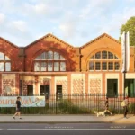
Poplar is a historic neighbourhood in the East End of London, situated within the London Borough of Tower Hamlets. Its identity reflects centuries of riverside trade, dock employment, working-class communities, migration, political change and urban regeneration. Visitors exploring Poplar encounter historic churches, former industrial areas, public housing landmarks, green spaces and the waterways that helped shape London’s maritime economy.
- What Is Poplar in East London Known For?
- How Did Poplar Develop Through London’s History?
- Which Historic Landmarks Should Visitors See in Poplar?
- Where Can Visitors Discover Poplar’s Docklands Heritage?
- What Can Visitors Learn About Poplar’s Working-Class History?
- Which Parks and Green Spaces Are Worth Visiting in Poplar?
- What Is Special About Chrisp Street Market and the Lansbury Estate?
- How Can Visitors Explore Poplar on Foot?
- How Can Tourists Reach Poplar and Get Around?
- When Is the Best Time to Visit Poplar?
- What Should Visitors Know Before Exploring Poplar?
- Why Should Poplar Be Part of an East London Heritage Visit?
The neighbourhood lies close to Canary Wharf, Limehouse and the Isle of Dogs. This location makes Poplar a useful destination for visitors interested in East London’s history beyond the capital’s best-known tourist attractions. Its streets reveal the relationship between the River Thames, the former West India Docks, local industry and the development of modern London.
Poplar also provides access to wider East End destinations, including the Museum of London Docklands, historic Limehouse and the riverside walking routes around the Isle of Dogs. A visit combines local heritage with contemporary architecture, public transport connections and everyday neighbourhood life.
What Is Poplar in East London Known For?
Poplar is known for its maritime heritage, historic churches, working-class history, distinctive housing developments and proximity to the former West India Docks. Located in Tower Hamlets, it connects the history of London’s docklands with modern Canary Wharf and the wider East End.
Poplar developed as a settlement on the northern side of the Isle of Dogs and near the River Thames. For centuries, its location connected local residents with shipping, river transport, warehouses and industries serving London’s expanding commercial economy.
The neighbourhood became closely associated with the West India Docks, which opened in 1802. These enclosed docks handled goods arriving from overseas, including sugar, rum and other commodities associated with Britain’s imperial trading networks. Their operation created employment in cargo handling, warehousing, transport and related trades.
Poplar’s identity also reflects the lives of dockworkers and their families. Dense housing, local markets, religious institutions and community organisations developed around the needs of a growing industrial population. The neighbourhood experienced poverty, industrial disputes, wartime destruction and major changes in employment as London’s docks declined during the twentieth century.
Today, Poplar combines residential streets and historic landmarks with newer developments near Canary Wharf. Its heritage remains important for understanding how East London changed from a maritime industrial district into part of a modern financial and residential landscape.
How Did Poplar Develop Through London’s History?
Poplar developed from a historic East End settlement into a major community associated with London’s maritime economy. Its growth followed the expansion of river trade, the opening of the West India Docks in 1802, industrial employment and twentieth-century redevelopment.
The history of Poplar is closely linked to the growth of London as a trading city. Its position near the Thames provided access to shipping routes and the commercial activities concentrated along the river’s eastern reaches.
During the eighteenth and nineteenth centuries, London’s population and overseas trade expanded. The construction of enclosed docks increased the demand for labour and supporting services. Poplar grew alongside these developments, accommodating workers, merchants, tradespeople and their families.
The West India Docks transformed the surrounding area by creating a controlled environment for unloading and storing imported cargo. Warehouses, dock entrances, roads and workers’ housing formed part of a wider industrial landscape.
The neighbourhood also developed a strong political and civic identity. In 1921, the Poplar Rates Rebellion became a nationally significant episode in local government history. Led by Poplar’s Labour council, the protest challenged the financial burden placed on a poor borough by London’s rates system. Councillors were imprisoned after refusing to collect certain levies, and the dispute helped strengthen the case for changes to local government finance.
The Second World War brought bombing and damage to London’s docklands. Later, containerisation and changes in shipping reduced the importance of traditional inner-city docks. The closure of the West India Docks in 1980 marked a major turning point.
Redevelopment subsequently transformed nearby docklands, particularly through the growth of Canary Wharf as a financial district. Poplar retained its residential character while becoming increasingly connected to new commercial centres.
As you explore the modern neighbourhood, its buildings and streets reveal a much older landscape. Read the full [Insert Anchor Text for Poplar’s History Article Here] to understand the origins of its historic landmarks, dockside communities and changing urban identity.
Which Historic Landmarks Should Visitors See in Poplar?
Poplar’s most important heritage landmarks include All Saints Church, the former Poplar Baths, Chrisp Street Market and historic buildings associated with local government and dock employment. These places explain the neighbourhood’s religious, civic, commercial and social development across different periods.
All Saints Church, Poplar
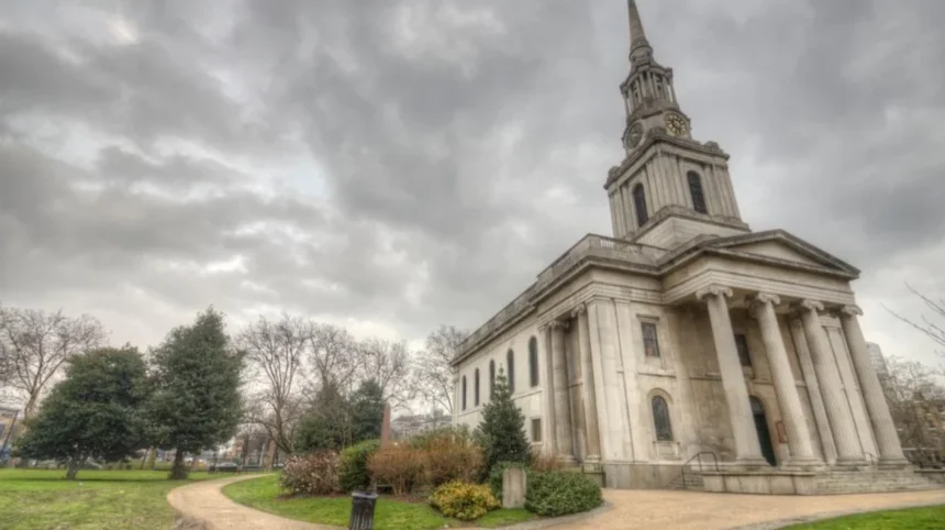
All Saints Church is one of Poplar’s defining historic buildings. The Church of England parish church dates from 1823 and stands near All Saints DLR station. Its prominent white spire provides a recognisable landmark along East India Dock Road.
The church was built during a period of rapid population growth. The expansion of the docks increased demand for housing, worship and community services. All Saints served the surrounding population and became an important feature of the developing neighbourhood.
The churchyard also has historical value. Tower Hamlets Council identifies the grounds as public open space and an area of importance for nature conservation. The former burial ground subsequently became a public garden, linking religious heritage with the development of urban recreation space.
Visitors should examine the exterior architecture and surrounding streetscape. Access to the church interior depends on its opening arrangements and scheduled activities, so check directly before planning a visit.
Former Poplar Baths
The former Poplar Baths is another significant local landmark. Its historic exterior reflects the development of public leisure facilities in East London and the importance of municipal services in densely populated industrial communities.
Public baths and swimming facilities played a practical role in urban life when many working-class households lacked modern bathroom facilities. Such buildings also provided opportunities for swimming, recreation and organised community activities.
The building forms part of the wider heritage landscape around All Saints and Chrisp Street. Its architectural character contrasts with the surrounding modern infrastructure, demonstrating how public buildings have adapted as the neighbourhood’s needs have changed.
Visitors should check the current use of the building before arranging an interior visit. Exterior viewing provides an opportunity to examine its architectural details and understand its place within the historic streetscape.
Former Poplar Town Hall
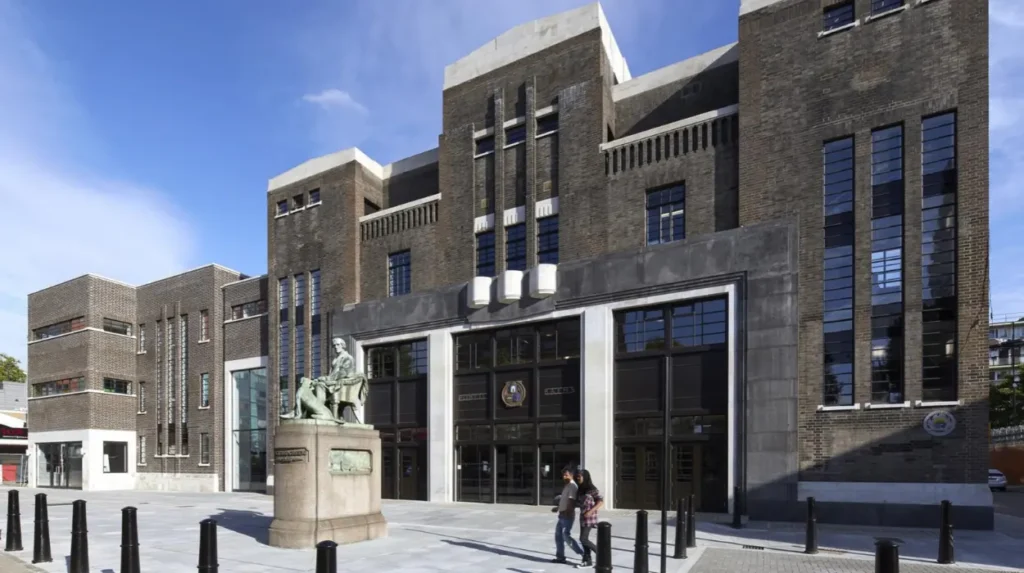
The former Poplar Town Hall represents the area’s civic history. Historic England records the building, now known as Bow House, as a former town hall designed by Culpin and Son in 1937–38, with later alterations.
The town hall recalls the period when Poplar operated as a metropolitan borough with its own local government institutions. Municipal authorities managed public services, housing, local infrastructure and community facilities. The borough’s political history is particularly important because of the 1921 Poplar Rates Rebellion.
The building’s history adds context to the neighbourhood’s wider story of local democracy and social reform. It is best appreciated as part of a broader heritage walk that includes All Saints Church and other civic landmarks.
Where Can Visitors Discover Poplar’s Docklands Heritage?
Visitors can explore Poplar’s maritime heritage through nearby dock basins, historic warehouse architecture, waterfront walking routes and London Museum Docklands. These destinations explain how overseas trade, dock labour, industrial technology and redevelopment transformed the surrounding East London landscape.
Poplar’s connection with the docks is essential to understanding its historical development. The nearby West India Docks opened in 1802 on the Isle of Dogs and became a major centre for the storage and movement of imported goods.
The docks were built to reduce congestion on the River Thames and provide secure facilities for cargo. Their warehouses stored commodities including sugar, rum, coffee and tea. These products connected London with international trading networks, including the Caribbean plantation economy and the exploitation of enslaved African people.
London Museum Docklands
London Museum Docklands is one of the most useful destinations for visitors researching Poplar’s surrounding history. The museum occupies No. 1 Warehouse at West India Quay, a surviving nineteenth-century warehouse associated with the West India Docks.
The museum’s exhibitions explore London’s port, river communities, migration, commercial expansion, wartime experiences and the legacy of slavery. Its galleries provide historical context that is difficult to understand from modern office towers and redeveloped waterfronts alone.
The original warehouse offers architectural evidence of the dock system. Its construction, cargo-handling features and relationship with the water illustrate how imported goods were stored and distributed. The museum also examines the wealth generated through imperial commerce and the human suffering associated with slavery.
The museum is near West India Quay DLR station and within reach of Canary Wharf. Check the official visitor information for current opening hours, exhibitions and access arrangements before travelling.
West India Quay and the Historic Warehouses
West India Quay preserves an important relationship between historic dock buildings and modern waterfront development. The surviving brick warehouses help visitors identify the industrial architecture that once dominated the area.
Warehouses were essential to dock operations. Workers unloaded cargo from ships, weighed goods, stored them securely and prepared them for distribution. The buildings required substantial floor space, durable construction and access to the water.
The area also reveals the consequences of deindustrialisation. West India Docks closed to general cargo operations in 1980 as containerisation and changes in shipping shifted commercial activity towards ports farther east. Redevelopment subsequently established Canary Wharf as a major financial district.
A walk around the accessible waterfront allows visitors to compare the older warehouses with contemporary office buildings. The route also offers opportunities for photography and a closer look at the relationship between conservation, commercial redevelopment and public space.
What Can Visitors Learn About Poplar’s Working-Class History?
Poplar’s working-class history reflects dock employment, crowded housing, public health challenges and campaigns for social justice. The 1921 Poplar Rates Rebellion is a defining example of local political activism, showing how borough leaders challenged financial arrangements that burdened poorer communities.
The growth of the docks created employment for porters, warehouse workers, lightermen, carters and other tradespeople. Their work supported London’s supply chains and connected local households with international commerce.
However, employment in the docklands also exposed residents to insecure wages, physically demanding labour and fluctuations in trade. Economic hardship affected housing conditions, health and access to essential services. Poplar’s civic institutions developed within this wider context of industrial inequality.
What Was the Poplar Rates Rebellion?
The Poplar Rates Rebellion took place in 1921, when Poplar Borough Council challenged the distribution of local taxation in London. Rates were local property-based taxes used to fund municipal and wider metropolitan services.
The council, led by Labour politicians including George Lansbury, argued that poorer boroughs carried an unfair burden under the existing system. Poplar had substantial social needs and a limited local tax base compared with wealthier areas.
Councillors refused to collect certain metropolitan rates and were imprisoned following legal proceedings. Their protest attracted national attention and contributed to pressure for reform of London’s local government finance arrangements.
The rebellion remains a significant example of local government challenging inequalities in public funding. Visitors interested in political history should consider it alongside the former Poplar Town Hall and the area’s history of housing provision and municipal services.
How Did Dock Work Shape Everyday Life?
Dock work influenced the daily routines, housing patterns and social institutions of Poplar. Employment often depended on the movement of ships and the availability of cargo, creating an economy closely linked to international trade.
Neighbourhood shops, pubs, places of worship and community organisations served residents working in the docks and related industries. The concentration of employment also helped establish strong local identities based on shared work and neighbourhood experience.
The decline of traditional dock operations during the late twentieth century changed this pattern. Container shipping required different facilities and methods, reducing the need for many jobs in London’s older enclosed docks. The transition brought unemployment and economic uncertainty to communities that had relied on maritime industries for generations.
Today, Poplar’s historic buildings and street layout provide a setting for understanding this industrial past. They also demonstrate why local heritage includes ordinary homes, public buildings and former commercial streets, not only grand monuments.
Which Parks and Green Spaces Are Worth Visiting in Poplar?
Poplar offers historic churchyards, neighbourhood gardens and nearby landscaped public spaces that provide breaks from busy roads and commercial districts. All Saints Churchyard is a particularly relevant stop because it combines historic architecture, local remembrance and green space.
Green spaces form an important part of Poplar’s heritage. Former churchyards and landscaped public areas show how urban communities adapted limited land for recreation, remembrance and environmental value.
All Saints Churchyard Gardens
All Saints Churchyard is a useful stop for visitors exploring Poplar on foot. The grounds connect the parish church with the surrounding residential neighbourhood and offer a quieter setting for observing the area’s historic character.
The churchyard was progressively converted into public recreation space after burials ended in 1862. The Metropolitan Public Gardens Association helped establish the public garden, with the work completed in 1905.
Visitors should look at the relationship between the church, the landscaped grounds and the surrounding buildings. This combination illustrates how nineteenth-century religious spaces became part of the public open-space network.
Bartlett Park and the Lansbury Estate
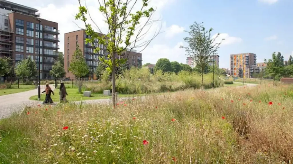
Bartlett Park provides another option for visitors interested in the relationship between public space and post-war housing. The park was laid out in the 1950s as part of the Lansbury Estate, a housing development associated with the Festival of Britain in 1951.
The Lansbury area demonstrates how planners sought to improve living conditions through housing, local shopping facilities and public amenities. The post-war development period changed the physical appearance of many East London neighbourhoods affected by wartime damage and housing shortages.
A visit to Bartlett Park works well alongside a walk around the Lansbury Estate and Chrisp Street. It provides a broader perspective on Poplar’s history, extending beyond maritime trade into social housing and urban planning.
Visitors should follow marked paths, respect residential areas and check local park information for facilities and accessibility.
What Is Special About Chrisp Street Market and the Lansbury Estate?
Chrisp Street Market is a longstanding East London shopping destination within the Lansbury Estate. Its covered shopping areas, everyday traders and nearby post-war architecture provide a practical introduction to local commercial life and the planning ideals that shaped Poplar after the Second World War.
Chrisp Street Market is an important place to experience Poplar beyond its historic buildings. The market serves local residents with everyday shopping, food and independent trading, while its pedestrian environment offers a view of the neighbourhood’s continuing community life.
The market is associated with the Lansbury Estate, which formed part of the Festival of Britain-era effort to demonstrate modern approaches to housing and urban design. The Festival of Britain took place in 1951 and showcased architecture, planning, science and design in post-war Britain.
The estate’s planning placed homes, shopping and public facilities within a connected neighbourhood. Chrisp Street became a central commercial space, reflecting the principle that residential communities require accessible everyday services rather than housing alone.
For tourists, the market provides opportunities to observe local food culture, purchase everyday goods and explore the streets on foot. Trading hours and stall availability vary, so visitors should check current information before travelling specifically to shop.
The market also offers a useful contrast with Canary Wharf. Both areas support commerce, but Chrisp Street’s community-oriented shopping environment differs from the offices, large retail spaces and corporate services associated with the financial district.
Visitors should treat the market as a working local destination. Ask permission before photographing traders or customers, keep pedestrian routes clear and check individual business hours when planning a meal or shopping stop.
How Can Visitors Explore Poplar on Foot?
A walking route through Poplar can connect All Saints Church, the former Poplar Baths, Chrisp Street Market and nearby docklands destinations. Starting near All Saints DLR station provides a practical way to explore local heritage while keeping the route flexible.
Walking is an effective way to understand Poplar’s changing urban landscape. The distances between landmarks, transport connections and residential streets make it possible to organise a visit around a few concentrated stops rather than a long cross-city journey.
A practical route begins at All Saints DLR station. Visit All Saints Church and its churchyard, then continue towards the former Poplar Baths and Chrisp Street Market. Allow time to examine the surrounding streets and the Lansbury Estate’s post-war architecture.
Visitors with additional time can continue towards West India Quay and London Museum Docklands. This extension connects local community history with the wider maritime economy and the transformation of the old docks into a modern commercial district.
Tower Hamlets Council publishes local walking routes, including In the Footsteps of the Dragon, which begins at All Saints DLR station and highlights churchyards, parks, public art and neighbourhood landmarks.
Before setting out, check the route on a current map. Construction, road crossings and access restrictions affect pedestrian journeys, particularly around major transport corridors and redevelopment sites. Wear comfortable footwear and allow extra time for museum visits.
For visitors with limited mobility, confirm step-free access at stations and check the accessibility of individual buildings and public spaces. Some historic sites have uneven surfaces, steps or restricted interior access.
How Can Tourists Reach Poplar and Get Around?
Poplar is served by the Docklands Light Railway, local buses and pedestrian routes connecting it with Canary Wharf, Limehouse and other East London destinations. Public transport provides convenient access from central London, while walking helps visitors explore the neighbourhood’s historic streets.
The Docklands Light Railway (DLR) is a driverless urban railway serving London’s Docklands and surrounding districts. All Saints is a useful station for visiting Poplar’s central historic landmarks, while nearby stations connect visitors with the waterfront and wider transport network.
The Jubilee line, Elizabeth line and other London Underground and rail services provide connections through nearby Canary Wharf and surrounding stations. Exact journey times depend on the starting point, service disruptions and interchange requirements.
Visitors should use Transport for London’s journey planner to check routes, fares, station accessibility and service updates. Contactless payment and Oyster cards are accepted on eligible London public transport services.
Local buses provide additional connections between Poplar and neighbouring districts. Walking is suitable for shorter journeys between the church, market and surrounding residential streets, although visitors should check crossings and construction diversions.
Cycling is another option for exploring East London’s connected streets and waterfront routes. Check current cycle infrastructure and parking facilities before travelling with a bicycle.
When Is the Best Time to Visit Poplar?
Poplar can be explored throughout the year, with daylight hours and dry weather generally making outdoor heritage walks easier. Weekdays provide a view of everyday local activity, while weekends suit visitors combining markets, parks and nearby cultural attractions.
Spring and summer provide longer daylight hours for examining architecture, walking between landmarks and visiting green spaces. Autumn offers opportunities to explore the neighbourhood’s historic streets in cooler conditions. Winter visits remain practical when visitors plan around shorter daylight hours and indoor attractions.
The best time also depends on the purpose of the visit. Visitors focusing on historic buildings should confirm access arrangements before travelling. Those interested in local shopping should check Chrisp Street Market’s current trading schedule. Museum visitors should verify opening hours and exhibition availability.
Poplar is a residential neighbourhood as well as a visitor destination. Respect private property, keep noise low around homes and places of worship, and follow photography restrictions at individual sites.
Explore More Area Guide
Exploring Limehouse: Historic Streets and Riverside Attractions in Tower Hamlets
Tower Hamlets Waterfront Guide: Historic London Riverside
What Should Visitors Know Before Exploring Poplar?
Visitors should plan their route, check opening arrangements and allow time for both historic landmarks and modern Docklands attractions. Poplar combines active residential streets with heritage sites, so practical preparation helps make a visit more informative and accessible.
A successful visit begins with selecting a manageable route. All Saints Church, Chrisp Street Market and the Lansbury Estate form a useful local itinerary. London Museum Docklands and West India Quay extend the experience towards the history of international trade and urban redevelopment.
Keep the following practical considerations in mind:
- Opening hours: Confirm access to church interiors, museums and individual attractions before travelling.
- Accessibility: Check step-free station access, pedestrian surfaces and building entrances.
- Transport: Use Transport for London’s journey planner for live service information.
- Food and shopping: Explore Chrisp Street Market and nearby businesses for everyday refreshments and local shopping.
- Photography: Respect residents’ privacy and any restrictions inside religious buildings or commercial premises.
- Historical context: Consider both the economic importance of maritime trade and its connections with slavery, imperial expansion and working-class hardship.
Poplar’s heritage is not limited to preserved buildings. Its identity also survives through public spaces, housing, local commerce and the street patterns shaped by centuries of urban development.
Why Should Poplar Be Part of an East London Heritage Visit?
Poplar offers a clear introduction to East London’s maritime history, working-class communities, civic activism and post-war planning. Its historic church, local market, public gardens and proximity to the former docks reveal how the neighbourhood evolved alongside London’s wider economic and social changes.
Poplar rewards visitors who look beyond major tourist landmarks. All Saints Church and its churchyard explain the development of a growing nineteenth-century community. The former Poplar Town Hall connects the area with local government, while the 1921 Rates Rebellion illustrates the political consequences of urban poverty.
Chrisp Street Market and the Lansbury Estate demonstrate the role of shopping, housing and public space in post-war neighbourhood planning. Nearby West India Quay and London Museum Docklands add an international dimension, connecting local life with global trade, the history of slavery and the transformation of London’s port.
The neighbourhood also offers practical opportunities for a flexible itinerary. Visitors can spend a short time exploring its central landmarks or combine Poplar with museum visits, waterfront walks and the contemporary architecture of Canary Wharf.
For anyone researching East London heritage, Poplar provides a useful way to understand the relationship between historic communities and a rapidly changing city. Its buildings, public spaces and surviving docklands connections preserve evidence of the forces that shaped modern London.
Where is Poplar in East London?
Poplar is a neighbourhood in the London Borough of Tower Hamlets, east of central London. It lies close to Canary Wharf, Limehouse and the Isle of Dogs, with convenient connections through the Docklands Light Railway (DLR).